Accommodation
Shelter (small),
'Walk-in' site,
Water Tank
'Walk-in' site,
Water Tank
Water Tank Level
View latest reported tank level.
Mapsheet
Mapsheet 7B, North of Mt Arden to Willochra Creek
Coordinates
Contact
https://www.heysentrail.asn.au (Friends of the Heysen Trail)
Bookings
No
Fees
None
Facilities
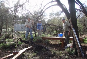
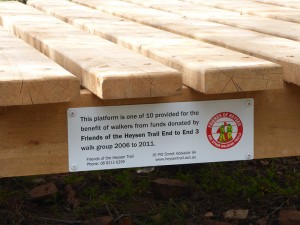
camp site, rainwater tank, shelter (very basic small shelter primarily to capture rainwater), multi-purpose camping platform
Notes
The site is not correctly located on the Heysen Trail mapsheet.


Spoke to staff from Buckaringa Sanctuary and animal culling began today and should finish 5/8/24. You will have to divert via Arden Vale Rd and Warren Gorge roads.
A more recent report was that the tank is now approx 3/4 full.
Tank less than 1/8th full on 12 August. Hopefully recent rain filled it. Nce site with a few good tent spots. Solar battery charger working well.
FoHT Trail Development team checked tank on 14/4/2022 – the tank was full.
N2S E2E 24.4.21
Tank seemed full with lovely water and great tap pressure. A camping platform makes a huge difference. We didn’t stay but went about 8km further on… got spectacular views… to make next day easier.
FoHT Maintenance team report the tank level on 29/7/20 was 50%.
Simon Cameron reported that the water tank was full on 7/9/19.
On July 7 E2E9 passed through and found the tank 2/3 full.
Tank seemed full or almost full. Only stopped for lunch the gecko in the log book box gave me a heart attack but seemed quite content ?
Stayed here on 1st July. Cleared site for tent lower from platform. No worries about pegs for ground soft enough. Tank had water. Firewood about but I got there too late to gather wood. Frost again next morning.
A nice campsite, tank seemed to be quite full ( 5/5/18). Walked from Mt Arden Sth. A challenging section along a creek bed with several “down hill” waterfalls. Only lasted an hour and a half or so.
Camped here overnight in October. Woke up sometime in the middle of the night with the sound of gunshots and ricochet off rocks with spotlights flashing around! Just lay as flat as I could until the commotion departed after a few minutes. The hariest part of the whole trail! Saw lots of goats before and after this camp site, so I’m assuming it was all legit. I did walk up to the lookout just west of the campsite to view the sunset on the wonderful surrounds.
Camped here overnight in October. Woke up sometime in the middle of the night with the sound of gunsots and ricochet off rocks with spotlights flashing around! Just lay as flat as I could until the commotion departed after a few minutes. The hariest part of the whole trail! Saw lots of goats before and after this camp site, so I’m assuming it was all legit. I did walk up to the lookout just west of the campsite to view the sunset on the wonderful surrounds.
I camped here the night of 5/9/15 tank almost full. Weather was perfect, I found it a lovely spot. Found a nice level tent site. Trees are bigger than in the picture.
Met a group from a Victorian bushwalking club here. Tank was 3/4 or so full. Platform is a handy spot for chatting and cooking off the ground. There are several small areas cleared of stones for tents. If it rained heavily I’d want to be very careful of tent position here, you may get flooded.
Got to be prepared to rock and roll
Looks a bit rocky from the pictures!