Accommodation
Self contained unit/house
Mapsheet
Mapsheet 1C, Victor Harbor to Mount Cone
Location
217 Nunn Rd, Myponga
6kms south west of Myponga.
6kms south west of Myponga.
Contact
holiday@fleurieuaccommodation.com.au
Ph (+61 8) 8558 3050
Ph (+61 8) 8558 3050
Bookings
Fees
Yes.
Facilities
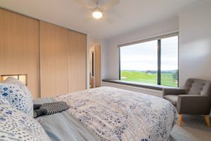
3 bedroom house. 1 sleepout with 2 loft beds, each with a double and a single.
2 bathrooms.
Full kitchen with outdoor entertainment area, incl BBQ.
Situated on a working family cattle farm.
2 bathrooms.
Full kitchen with outdoor entertainment area, incl BBQ.
Situated on a working family cattle farm.
