Inman Valley

Accommodation Option on the Heysen Trail

Inman Valley Hall, picnic area and toilets
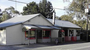
Inman Valley shop
Inman Valley shop
Accommodation
Town
Water Tank Level

View latest reported tank level.

Report the tank level.

Mapsheet
Mapsheet 1C, Victor Harbor to Mount Cone
Guidebook
Southern Guidebook, chapter 2, map 3
Coordinates
Longitude: 138.458313
Latitude: -35.493382
Download
Download GPX file for a GPS unit
Download KML file for Google Earth/Maps

Displaying 2 accommodation options in this town

Alma’s Hem Amphitheatre

Camp Kitchen
3 additional photos on
heysentrail.asn.au/?p=91531
Accommodation
Campsite
Guidebook note

Just off eastern boundary of map 2.3

Coordinates
Grid ref: 723 686
Longitude: 138.48910
Latitude: -35.50080
Download
Download GPX file for a GPS unit
Download KML file for Google Earth/Maps
Facilities

Toilets, RV, caravans, tents.
Firewood and pit in season
Gas BBQ and Pizza Oven
Rainwater on request.

Inman Valley town campsite

Accommodation
Campsite,
Water Tank
Location

1713 Inman Valley Rd, Inman Valley.
Adjacent to the Inman Valley Memorial Hall and across the road from the Inman Valley General Store.

Coordinates
Grid ref: 694 692
Longitude: 138.457744
Latitude: -35.493793
Download
Download GPX file for a GPS unit
Download KML file for Google Earth/Maps
Contact

Inman Valley Community and Memorial Hall Association:
ivmemorialhall@gmail.com

Facilities

Tent pad near toilet block, water tank.

View full featured Interative Map of the Heysen Trail - showing additional information layers such as Re-routes, Guidebook map outlines, photos and Fire Ban Districts.

One thought on “Inman Valley

Comments are closed.