Accommodation
'Walk-in' site,
Water Tank
Water Tank
Water Tank Level
View latest reported tank level.
Mapsheet
Mapsheet 3C, Marrabel Golf Club to Tothill Gap
Coordinates
Contact
Friends of the Heysen Trail
Bookings
No
Fees
None
Facilities
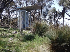
Shelter with water tank and bench, and square camping platform/bench.
Notes
Campsite completed September 2012.
The site is not correctly located on Heysen Trail Mapsheet 3C.
Follow these directions - if walking from the south, after turning off Kerchens Rd, continue east along the Webb Gap Rd for 1.4 kms to the high point at GR 116 384. At that point on the northern side of the road you will find a HT marker post with a tent symbol. This marks the stile that walkers use to access the site, about 100 metres north.
Distances:
Smith Hill Walk-in site to Webb Gap Walk-in site - 13.3km
Webb Gap Walk-in site to Huppatz Hut - 16.2km

FoHT Trail Development team visited the site 19/5/2022.
Tank was full and water clear.
Platform fixed. Water in tank. 25/8/21
E2E S2N there 21.5.21
Shelter and it’s bench seat in good nick. Water tank has plenty of good water. Unfortunately camping platform vandalised and unusable with all planks missing and nowhere to be found.
Stayed at Webb Gap 28/07/2020 – Steep climb to this bush campsite from either direction, it is situated close to the top, just off the trail. Keep your eyes open for the stile as the tank is not easy to spot from the road. This site has some challenges; the ground is sloping in most places, areas of ground are rocky and very hard, and the multi-purpose platform is in disrepair. But the water tank was full of good water, the camp is mostly in in the lee of the prevailing wind, and watching dawn from this site is a real treat. Note that prior recent users of Webb gap have not dug adequate cat holes, and much too close to the water tank. Take care when choosing where to pitch your tent, and remember to dig your cat holes well away from the camping area and waterways.
Campsite is miss located on the map (map sheet 3C). Actual location is at the highest point of road on the northern side. Basically right where Webb Gap is printed on map.
Nice spot that I stopped through on 5 June. Not too many level spots for tents. Looked to be a newish multi-use platform which is great. Water tank at least 30%.