


On Monday 13 August 1984 the members of the Jubilee 150 Heysen Trail Walking Project re-convened at Melrose to commence the fourth stage over the next ten days. Reaching the historic Kanyaka Ruins was our objective for the stage, a significant point also be because it was the half-way point of our walk from Cape Jervis on Fleurieu Peninsula and Mount Babbage at the northern tip of the Flinders Ranges.
It was impossible to avoid periods of inclement weather from time to time during the walk. The greatest frustration when inclement weather did occur was passing through an area of great beauty or interest and missing the experience. But then there is the experience and satisfaction of copping with the inclement weather.
After staying overnight in onsite vans at the picturesque Melrose Caravan Park, an almost full complement of walkers from the Burra to Melrose stage gathered on Tuesday 14 August in the cool early morning outside the Melrose Post Office. Unfortunately Lyn Steven had fallen victim to flu only days before the walk was to commence and had to withdraw.
Our initial course lay alongside the bitumen road leading north out of the town towards Wilmington. After two kilometres we entered the red gum studded Melrose Showgrounds and then walked along a narrow bush track to the base of Mount Remarkable. We had now entered the eastern section of the Mount Remarkable National Park.
Setting out to climb Mount Remarkable just an hour after starting the stage, with fully laden packs, had caused a great deal of discussion as we had driven to Melrose the previous day. Slow and steady was the approach as we commenced the 600 metre ascent. The thick vegetation blocked some of the views to the east over the southern Willochra Plains, with only occasional openings providing the inspirational views which are so helpful when experiencing the considerable effort of steep ascents.
Well before lunch, with relief, we reached the summit (960 metres) and although vegetation continued to restrict the view we were well satisfied with our morning’s effort under heavy packs.
A rough track along the slowly descending top of the Mount Remarkable Range lead us north. Two kilometres on we diverted west towards the steep drop from the ridge into Spring Creek. Lunch was taken on broad saddle overlooking the deep chasm which led down to the creek. We successfully negotiated the steep and rocky scree slopes down to Spring Creek, detouring around a snake found sunning itself amongst the rocks.
Following the creek downstream to the north we stopped to admire the strongly flowing Goat Rock waterfall. We continued to follow Spring Creek downstream, passing Cannon Swamp, and in the mid-afternoon we selected our campsite a short distance from an unfenced road reserve we would use the next morning to pass from the eastern section of Mount Remarkable National Park to the much larger western section.
Leaving our packs we walked a further two kilometres downstream along Spring Creek to the site of the historic Spring Creek Mine. This copper mine was one of the earliest in the area. As a result of flooding of the shafts as they were driven deeper, which caused the mine to be abandoned not that long after it was established, the mine is utilised as the source of nearby Wilmington’s water supply. We returned to our campsite in the late afternoon.
Following an extremely cold night, evidenced by the frosty white blanket adorning the scene the next morning and the solid blocks of ice in our various water containers, we soon warmed up as we slowly climbed out of the Spring Creek valley, walking west along a rough bush track.
The eastern and western sections of Mount Remarkable National Park are separated by a two kilometre wide section of private grazing land. The only means for walkers to cross directly between the two sections is by way of this one chain (22 yard) wide road reserve. I had heard of attempts to bluff walkers from using this corridor and so to ensure we stayed on the road reserve I took particular care to follow our progress on the topographical-cadastral map I was carrying. I wanted to be certain of being able to justify our position on the road reserve if challenged during the forty minutes or so it took to walk from the eastern section to the western section.
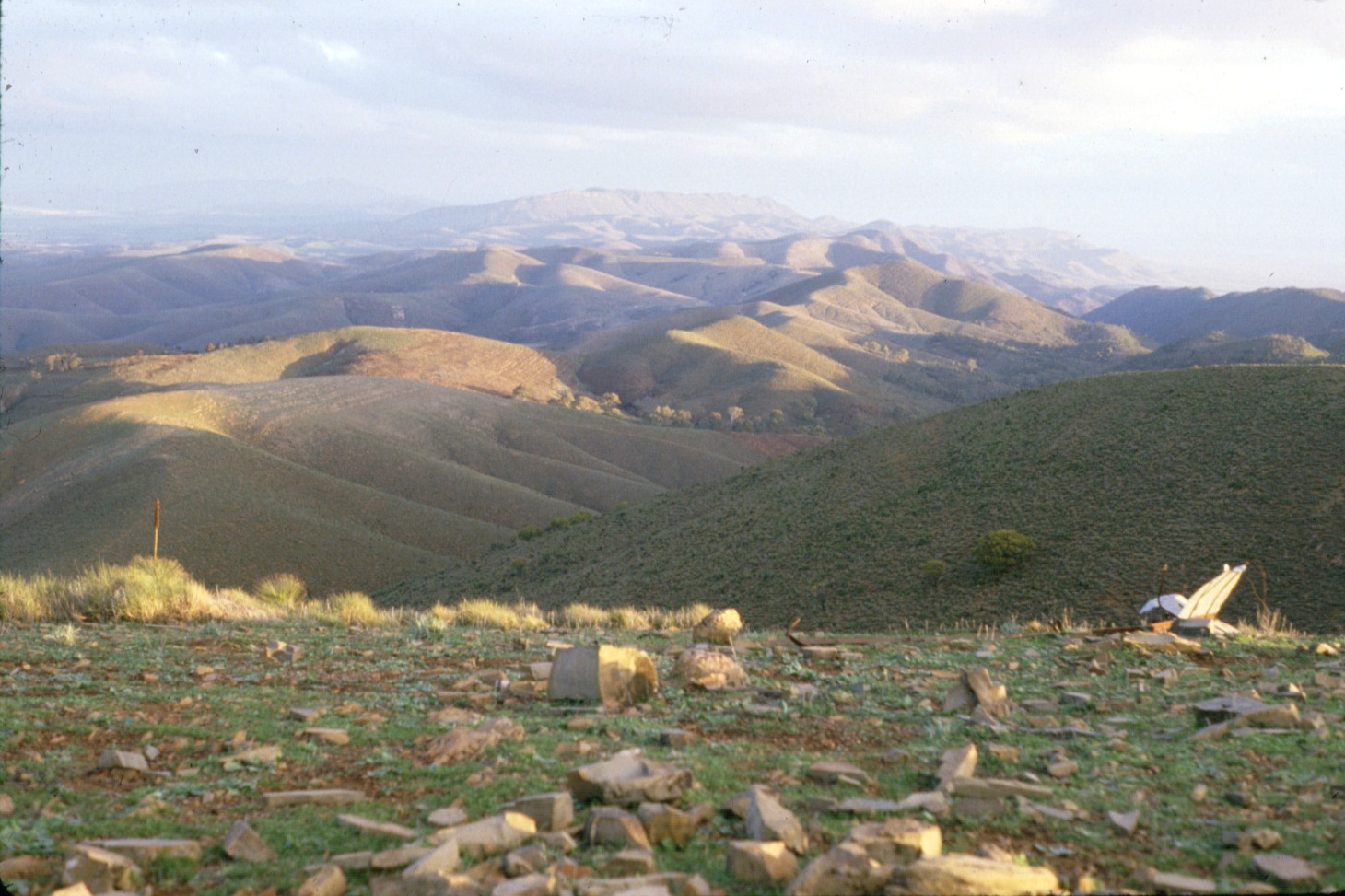
The western section was reached without incident. We followed various fire trails south and then west before diverting south again to follow a narrow ridge – the watershed between the Willochra drainage system to the east, eventually flowing into Lake Torrens, and the Alligator and Mambray Creek systems to the west that flowed into Spencer Gulf. Excellent views of the vast Alligator Creek pound-like basin were a constant feature for much of the remainder to the day as we walked south to Black Range. From several points the summit of Mount Brown could be seen well off to the north. Progress was slow due to the combined effects of the warm weather, the thick vegetation and the rugged ridge top.
In the late afternoon we reached Mount Cavern (770 metres), on the Black Range. When I was first introduced to the area by the Duke of Edinburgh Award Scheme in the late 1960s, Mount Cavern was known as Black Hill. We still needed to descent 570 metres to our planned campsite on the banks of Mambray Creek. Several of the group, including myself, were quite exhausted by the day’s effort and suffered from ‘rubbery legs’ as we descended the established walking track in a race to reach the bottom before dark. At one stage I needed to sit by the side of the trail for many minutes before my legs regained the strength to continue.
An attractive campsite in an idyllic grassy native pine and red gum studded setting was established within metres of the base of the descent from Mount Cavern. Given the exhausted condition of my companions I didn’t have the heart to mention the effort of the previous two days had advanced our northwards progress from the latitude of Melrose by just 500 metres.
The extent of the recovery of even the most exhausted of our group from their condition the previous evening was miraculous when we set out the next morning. Only a short walk brought us to the junction of Mambray and Alligator Creeks. After a delightful walk upstream along Alligator Creek past Pine Flat we reached the entrance to Hidden Gorge. Despite walking in the Mambray and Alligator Creek on a number of occasions this was the first time I was to visit Hidden Gorge. I had been particularly looking forward to this section of the walk.
We all enjoyed one of the best sections of walking trail in the Flinders Ranges and were well satisfied with the morning as we emerged from the gorge at the top of The Battery range. We turned north following the fire trail along the ridge top, pausing for lunch near The Battery (~ 610 metres) at noon. As we ate we became aware of a strong weather front approaching steadily from the west, reminiscence of our experience near Pewsey Vale Peak on the second stage of our walk. It was inevitable that we were going to get quite wet before long.
It was impossible to avoid periods of inclement weather from time to time during the walk. The greatest frustration when inclement weather did occur was passing through an area of great beauty or interest and missing the experience. But then there is the experience and satisfaction of copping with the inclement weather. In several days we would be ascending Mount Brown. The two previous times I had been to the top of Mount Brown low clouds and rain had completely blocked out the view. Surely that couldn’t happen again.
Within an hour of finishing our lunch break the storm front arrived. All of a sudden, high up on The Battery range, we were enveloped in cloud and being drenched by steady rain. Navigation was to be critical as we reached the northern end of The Battery range. Originally it was intended to leave our packs on top of the range and walk down The Terraces to Alligator Gorge. The continuing steady rain and poor visibility coupled with the navigational challenges we faced combined to convince us to press on to get to our planned campsite and to shelter in our tents as quickly as possible.
By noting the few distinctive various reference points at the northern end of The Battery range, estimating our walking speed and the time we had been walking we successfully selected the correct point to divert north-west through a narrow gorge to Hancocks Lookout Road. We emerged from the clouds at the base of the gorge and the rain was just beginning to ease as a campsite was selected in a grove of mallee trees adjacent to the road, one and a half kilometres south of the intersection of Hancocks Lookout Road and the Horrocks Pass Road.
Our camp fire that night served many purposes as in turn it was used for warmth, drying clothes and cooking tea. A minor crisis occurred when a drying pair of socks suspended above the fire fell into a simmering billy of soup.
The weather had almost cleared as we set out the next morning, soon reaching the bitumen Horrocks Pass Road. This was followed to the top of the Pass. After pausing briefly to inspect the Horrock Memorial in cool blustery conditions we walked north up a steep rough track. A wide road reserve, following the top of the ridge north for fifteen kilometres, would now lead us to the base of Mount Brown. This was our route for the remainder of the day. As we followed the ridge higher the cool south-westerly wind became progressively stronger.
The hills were quite bare, offering little protection and lunch was taken in a barely sheltered area on the eastern side of the ridge. A minor problem occurred when I was the last to pack up and leave the lunch spot and my companions took a wrong turn and started to follow a ridge heading in the direction of Port Augusta.
We continued to follow the ridge north throughout the afternoon, passing the headwaters of Yapoona Creek and then Minbadoggie Creek to the east and Deep Creek and then Spear Creek to the west, only dropping down off of the ridge to the west into the headwaters of Mount Brown Creek in the late afternoon to find a suitable campsite. As we established our campsite the clouds descended and light rain began to fall. Fortunately it soon stopped. At 600 metres above sea level this was our highest campsite since reaching the Flinders Ranges. At this altitude and time of the year the likelihood of being clouded in was relatively high. In the morning we would climb Mount Brown, the highest point of the walk so far. As we prepared tea discussion centred on the conditions likely to be encountered the next day.
Showers fell during the night and a thick mist shrouded the area as we prepared to set out. Mount Brown Creek was followed upstream for a kilometre before we commenced contouring around the hills in a steady climb to the north. The wind grew stronger as we got higher and by the time we reached the saddle east of the summit of Mount Brown the wind was blowing a gale and mist was swirling around. Carlien volunteered to stay with our packs at the saddle and we quickly ascended the further 180 metres of height to the summit (~ 970 metres) – in thick cloud. Third time to the top and Mount Brown without the opportunity to enjoy the view. I was tempted to wait for some time in the hope that the weather would clear but the very cold windy conditions and knowledge of our demanding schedule later in the day and in the days ahead convinced me to press on. Perhaps I will be luckier the fourth time I reach the top of Mount Brown. (I was, but that wasn’t until 2004.)
Returning to Carlien we retrieved our packs and walked east contouring around the northern side of Mount Brown East before following a long descending ridge that would take us to Waukarie Creek. As we commenced our descent the weather began to clear and before long the summit of Mount Brown temporarily emerged from the clouds. We reached the base of the ridge near Waukarie Waterfall at noon.
Our lunch site was in an attractive setting on a grassy slope only a few metres from the waterfall, with a small stream of water cascading over the ten metre drop.
A delightful walk down Waukarie Creek compensated for some of the disappointment of the morning. As we emerged from the steep sided valley in the mid-afternoon the spectacular Devils Peak dominated the view to the north. Continuing to walk along Waukarie Creek we reached Woolshed Flat, a former siding fettlers camp in Pichi Richi Pass. As we approached Woolshed Flat the summit of Mount Brown was again shrouded in clouds. In addition to camping at Woolshed Flat this was our half-way supply point for the stage. Woody’s sons had kindly offered to bring up our supplies from Adelaide and they arrived in the late afternoon. It had been suggested to Lyn that she should join us for the second half of the stage if her flu had abated but this had not occurred.
We left at 7.30 am the following morning, without packs, to climb Devils Peak. After walking across the historic railway bridge over Waukarie Creek we walked along the narrow gauge Pichi Richi railway line north, reaching the site of the old Pichi Richi township after an hour and a half. Now just north of Devils Peak we crossed over the Port Augusta to Quorn road, and commenced a steep climb to the summit. In an hour we reached the northern and highest point of the summit (~ 700 metres). We stayed on the summit for some time, admiring the magnificent view over to, now cloud-free, Mount Brown.
It took some effort to work our way along the top of the ridge to its southern end before following a suitable spur down to the railway line. Retracing our steps we reached Woolshed Flat in time for a late lunch. By the time we had finished lunch and loaded up our food for the remainder of the stage it was mid-afternoon when we commenced following the railway line south, a kilometre on crossing another impressive railway bridge, similar to the well-known bridge over Waukarie Creek, but relatively unknown because it is not easily seen from the Port Augusta to Quorn road.
Continuing to follow the railway line as it swung to the west and soon reached the former settlement of Saltia near the entrance to Pichi Richi Pass. Nothing of Saltia remains. At Saltia we recommenced our northerly progress, ascending the end of a high ridge we were to follow for nineteen kilometres to the Dutchmans Stern. Soon after crossing over Saltia Hill (~ 470 metres) the unmistakable sign of feral goats was a disturbing feature. It was soon clear our progress along the top of the ridge was not going to be as rapid as I had anticipated. The ridge was reasonably flat but thick vegetation slowed progress. Late in the afternoon a campsite was established in a small valley just off to the eastern side of the ridge and only a small distance north of the latitude of Woolshed Flat.
Next morning we returned to the ridge top and continued north. Progress slowed further as the vegetation became progressively thicker. Late in the morning we reached the point where the Albury Vale track crossed the ridge. I was concerned we were now several hours behind schedule and I decided to vary from the planned route. The planned route was to follow the ridge north all the way to the Dutchmans Stern, still ten kilometres away. I decided to skirt around to the western side of the ridge and utilise a series of station tracks indicated on the map in an effort to get back on schedule.
Lunch time was approaching when we reached the starting point of our western traverse, above the headwaters of (another) Deep Creek. A cold wind was blowing strongly from the south-west as we lunched, huddled for protection in low bushes, with magnificent views to the west to the plain 500 metres below. The area between the Dutchmans Stern Range and the western plain is some of the most rugged in the Southern Flinders Ranges and we were treated to great views down steep valleys and gorges as we proceeded north after lunch. To add to the spectacle the top of the Dutchmans Stern Range to the east towered a further 200 metres above us.
Soon after lunch, above the headwaters of South Creek, we reached a rough station track leading north, enabling us to make up the time lost the previous afternoon and during the morning. About two kilometres from ‘The Dutchman’ homestead we left the track and continued north along the watershed between the Willochra Creek drainage system on the east and the west flowing streams. Late in the afternoon we were approaching ‘Depot Flat’ station and with rain threatening we decided to camp near a windmill and tank on Nathaltee Creek. A brief shower fell as we erected our tents adding a sense of urgency to our efforts. The weather cleared soon after but remained cool and blustery. The persistent cool windy conditions of the previous four and five days had become tiresome. We had made excellent northwards progress during the day but I was disappointed the original plan of walking along the top of the Dutchmans Stern Range from Saltia to the Dutchmans Stern had not been achieved. This disappointment was balanced however by the anticipation of visiting Eyre’s Depot Creek in the foothills to the north-west the following day.
We found ourselves enveloped in thick clouds when we woke the following morning. This was going to provide a further challenging navigational exercise. Our route was to continue to follow a watershed for several kilometres to the west and then north, and then follow a specific ridge to the north-west to the base of the range at Eyre’s Depot Creek. But with visibility less than 50 metres would my map reading and ground interpretation skills enable us to continue along the watershed and then pick the right ridge?
Carefully we walked over Depot Creek Hill (~ 570 metres) and along the bare featureless ridge before selecting the ridge that was to take up down to Depot Creek. Fortunately the navigation was successful, but only confirmed as we emerged from the clouds at about 450 metres above sea level. By mid-morning we neared the base of the range at the point Depot Creek flows out of the range and out onto the western plain. At less than 200 metres above sea level we were at the lowest altitude since walking up Sugarloaf Hill overlooking Inman Valley nearly thirty walking days earlier.
Bob had visited Depot Creek several months prior to our arrival. We left our packs at a spot to which we would return for lunch and he led our exploration of the area. Of interest was a substantial historic concrete weir, now completely choked with silt and rocks brought down from upstream during floods, and an abandoned mine just upstream from the weir. Apparently the weir was constructed to collect water for the Port Augusta’s early, steam-age, railway activities.
We returned to our packs and after lunch followed a substantial tributary of Depot Creek upstream to the north. The afternoon provided one of the most enjoyable walks of the stage, rivalling Hidden Gorge. This beautiful meandering creek, bounded by steep rugged cliffs, led us eight kilometres as the crow flies, but nearly double that distance with the constant meandering of the creek east and west, as we journey to the north, almost to the summit of Mount Arden. I had planned to camp in the upper reaches of the creek depending on the availability of water. Whilst water had been plentiful for the first several kilometres after leaving Depot Creek I misjudged when to secure water for our campsite that night and before I realised the creek had become waterless. Earlier in the day I had indicated to my companions that we would be camping on water so all of our supplies were low. When it became clear there was little likelihood of water in the remainder of the creek I had to decide whether to turn back to where water could be obtained or press ahead to the next expected water source at Hannimans Gorge, still more than six kilometres ahead. We decided to push on. Late in the afternoon we emerged from the headwaters of the creek, 740 metres above sea level, and only 100 metres less than the height of Mount Arden, the summit of which stood out plainly just a half a kilometre away to the north-west.
In circumstances similar to those at Mount Cavern a week earlier it would be a race against the approaching darkness to reach our campsite and water. Did we have time to reach the summit of Mount Arden and then dash to Hannimans Gorge in time to secure a water supply and a suitable campsite before dark? Woody and I decided to strike for Mount Arden whilst the others headed directly to Hannimans Gorge to secure the water supply and a suitable campsite whilst it was still light.
Woody and I virtually jogged to the summit of Mount Arden (844 metres). In one respect we were fortunate events had transpired the way they had that day – in the evening light the various shadows and shades contributed to stunning views all around but particularly of the Dutchmans Stern Range, eighteen kilometres to the south. Now, without a minute to spare, we sped east as quickly as we could with safety, given the failing light. In the half-light we could just see our companions 500 metres in front.
We were fortunate to pass through the steeper rocky areas whilst there was sufficient light. As we got to the softer and flatter country to the east we paused briefly to take our torches out of our packs and hurried on. It was dark when Woody and I caught up with our companions just as they selected a campsite. The sound of water trickling in the adjacent creek at the head of Hannimans Gorge was a welcome sound. We had made it – but only just!
Compared with the drama of the previous day the route and events of the following day were very much an anti-climax. Leaving our campsite at the customary 8.00 am we walked north along the western flank of the distinctive narrow range which is dissected by the well-known Warren and Buckaringa Gorges, as well as Hannimans Gorge. After three kilometres we reached Buckaringa Gorge which we walked through along a well-known gravel road. Passing the ‘Willow Glen’ property and crossing the broad Mount Arden Creek we followed a substantial gravel road north-east. Shortly before lunch we paused at the historic grave of Hugh Proby. Lunch was taken under shady trees on the southern bank of Mount Arden Creek. Soon after lunch we crossed the very saline Willochra Creek and then after passing through the phantom township of Simmonston, Kanyaka Creek was also crossed as we passed through to the eastern side of the curious Dyke ridge.
Simmonston is at the northern end of the Willochra Plain. The topographical-cadastral map we were using clearly indicated the many small sections into which the Plain had been surveyed during the foolishly optimistic wheat growing expansion of the 1880s and 1890s. The map indicated that there were ruins on many of these allotments, testimony to the folly of those times. Our goal for the day was one of the ruins at the base of Hut Hill. As if to compensate for the previous day we reached our campsite by mid-afternoon.
We debated whether to climb Hut Hill, 280 metres above our campsite and just a kilometre away to the north, but I indicated the plan was to climb it from the north on the first day of the next stage and enthusiasm, given the exertion of the previous day, quickly waned. As this was the final night of the current stage of the walk our evening meals tended to be mixtures of leftovers and the extra supplies we all carried in the event of unforseen delays, that is, a feast of sorts.
Our destination the next morning was the ruins of the former Kanyaka head station. We walked east along an unfenced road reserve before commencing a steady 200 metre climb to the rocky top of a small range of hills. We reached the top about 500 metres south of Kanyaka Hill. Woody, Bob and I left our packs and walked to the summit (~ 580 metres) whilst the others continued south-east to the Kanyaka ruins, now visible on the east bank of Kanyaka Creek.
The diversion was well worthwhile, particularly to experience the magnificent views to the south and west. The distinctive Wyacca Bluff and recently visited Mount Arden caught our eye to the west and south-west whilst in the south the Dutchmans Stern, Devils Peak, Mount Brown, and Mount Remarkable, our starting point for the stage, were prominent. The vast flat bare Willochra Plain in the foreground added to the spectacle.
Returning to our packs the summit group hurried east, although a little more to the south than our companions in order to inspect the shallow Kanyaka mine diggings. By 10.45 am we had all reached the ruins. We were surprised and pleased to find several workmen at work at the site stabilising the walls of the ruins for the State Heritage Branch.
Congratulations were extended all-round. In terms of physical effort this stage had been the most difficult we had experienced thus far. We had ascended and then descended from major peaks and ridges on six occasions over ten days, each time with laden packs. The number of late finishes during the stage was an indication that I need to be more conservative in planning our route for the four remaining stages to Mount Babbage.
We had reached the halfway point. Whilst the number of walkers had dropped to nearly half of the number that started at Cape Jervis, a strong group remained. I hoped we would all share the satisfaction of reaching Mount Babbage two years hence.
Jump to content:
- Introduction – The First End-to-End walk of the Heysen Trail
- Stage One – Cape Jervis to Cudlee Creek
- Stage Two – Cudlee Creek to Burra
- Stage Three – Burra to Melrose
- Stage Four – Melrose to Kanyaka Ruins
- Stage Five – Kanyaka Ruins to Aroona Hut
- Stage Six – Aroona Hut to Sliding Rock Mine
- Stage Seven – Sliding Rock Mine to Arkaroola
- Stage Eight – Arkaroola to Mount Babbage