Accommodation
Water Tank
Water Tank Level
View latest reported tank level.
Report the tank level.
Mapsheet
Mapsheet 6C, Wilmington to Woolshed Flat
Guidebook
Northern Guidebook, chapter 3, map 5
Coordinates
Facilities
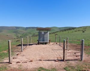
Water tank, bench
Hikers may camp here but it is windy and exposed.
Fire Danger Season - this walk in-site is closed during CFS Fire Danger Season
(Check dates that vary annually between October & May at https://cfs.sa.gov.au/warnings-restrictions/restrictions/fire-danger-season-dates-permits/#dates )
Hikers may camp here but it is windy and exposed.
Fire Danger Season - this walk in-site is closed during CFS Fire Danger Season
(Check dates that vary annually between October & May at https://cfs.sa.gov.au/warnings-restrictions/restrictions/fire-danger-season-dates-permits/#dates )
History
In August 2024, volunteers installed fencing around tank to restrict access from cattle - please keep gate closed.
Notes
New tank installed in April 2022.
Closest water sources are Stony Creek, 14 km south and Catninga 13 km north.

Wondering what the site would be like for camping? Otherwise it’s a very long walk between Stony Creek and Catninga Shed. Any advice would be appreciated, thanks!
Michelle,
It’s a very exposed site. Could be very windy, though I believe great views east and west. Need to be sure your tent is well tied down.
Cheersssss
Julian
More recent report suggests water just above tap level. In other words not that much!
Tank estimated to hold less then 10% on 24/4/2022, however rained that weekend.
Tank installed by FoHT Trail Development team on 10/4/2022. Do not rely on this tank until good rains fall in the area. Through walkers are asked to observe tank level and submit reports to the Friends Office for posting here.