Section 22: Peters Hill to Gerkie Gap

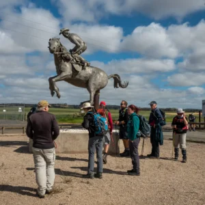
A pleasant walk along back roads through undulating farmland to the southern end of Tothill Range, taking in the town of Marrabel and its memorial to the famous buckjumper 'Curio'.

Quick stats
18km

Warning to walkers:

1. Avoid livestock on the trail immediately north of Peters Hill Rd.

Immediately after crossing Peters Hill Rd, the trail follows a road reserve that has been leased to a farmer. Walkers are asked to take care and avoid sheep that graze on the property. Please approach them carefully to ensure they are not stressed and that lambs and ewes are not seperated.

2. Ford crossing the Light River at Marrabel.

There is a ford across the Light River on Tarnma Road, Marrabel that may be impassible when the river is flowing strongly.
The ford is located 200 metres east of Marrabel Road, Marrabel and the Marrabel Rodeo ground ‘walk in’ site.

Hikers walking west on Tarnma Rd (towards Marrabel) during wet weather are advised to consider taking an alternative route. The suggested wet weather route is to turn left onto Links Road and right onto Golf Course Road, continuing for 2 kms to Marrabel Road. Walkers should then turn right until they return to the marked trail at Tarnma Road.

If this route is not followed during wet weather, walkers continuing along Tarnma Rd to the river crossing may need to turn around and walk 2.3 kms back to the turn off to Links Road.

Map & GPS Files

View map in full screen format.
View full featured Interative Map of the Heysen Trail.

Download GPX file for a GPS unit.
Download KML file for Google Earth/Maps.
Download full-featured GPX and/or KML files of the Heysen Trail.

Mapsheet 3B, Kapunda to Marrabel Golf Club;
Mapsheet 3C, Marrabel Golf Club to Tothill Gap

Southern Guidebook, chapter 5 map 3.
chapter 5 map 4.
chapter 5 map 5.

Location of Peters Hill
026 167
(302600 6216700 zone 54)
Latitude: -34.1719991111 (34° 10' 19.1968")
Longitude: 138.8582884333 (138° 51' 29.8384")
View in Google Maps
Location of Gerkie Gap
112 250
(311200 6225000 zone 54)
Latitude: -34.0987843306 (34° 5' 55.6236")
Longitude: 138.9533463111 (138° 57' 12.0467")
View in Google Maps