Heysen Trail closure through the Buckaringa Sanctuary, Friday 1st July to Wednesday 6th July 2022.


The Buckaringa Sanctuary will be temporarily closed for 5 days in early July 2022. As the Heysen Trail passes through the sanctuary, we advise walkers to consider the closure if planning to walk in the area.

The closure was originally planned for early June. Due to a number of factors the new dates for the closure are :

  • Commencing at 5pm on the evening of  Friday 1st July through to 8am on Wednesday 6th July 2022.


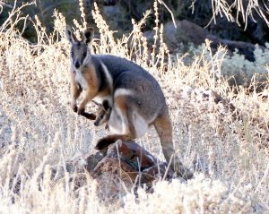
The sanctuary is home to many Yellow-footed Rock-wallabies and is located between Quorn and Hawker. You can find it on map 6, chapter 4, of the Heysen Trail Northern Guidebook and on Sheet Map 7b – Dutchmans Stern Conservation Park to Mernmerna Creek.

The closure affects the trail in the following walk sections:

51 Warren Gorge to Buckaringa Gorge

52 Buckaringa Gorge to Callabrinda Creek


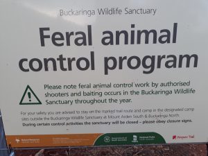
The closure is because the Australian Wildlife Conservancy (AWC) will be undertaking feral animal control in the sanctuary.

AWC will place closure signs at all entry points to the sanctuary to warn walkers of the danger.
Heysen Trail GPX files update for GPS: 13 re-routes and corrections

A collection of re-routes and corrections of the trail path in the downloadable GPX file and Interactive Map.

These re-routes have also had a minor +3km impact on the Heysen Trail Distances.

The following re-routes, updates and corrections have been added::

  1. Mapsheet 2B – minor correction of display of trail route around Morialta Barns
  2. Mapsheet 2D – reroute of trail along Tower Rd/Ross Fire Track to take the trail off Wirra Wirra Rd
  3. Mapsheet 3A – minor correction of display of trail route to show it following Roennfeldt Rd near Sturt Highway
  4. Mapsheet 3B – minor, display Marrabel ‘Walk-in’ site on download files
  5. Mapsheet 4A – show reroute of trail through the southern part of Caroona Creek Conservation Park, and more accurate alignment in the northern part of the Conservation Park
  6. Mapsheet 5A – minor, display Bundaleer Sports ground campsite on download files
  7. Mapsheet 5B – show reroute of trail through main street of Crystal Brook
  8. Mapsheet 5B – show reroute of trail north of Bowman Park
  9. Mapsheet 6A – show reroute of trail in Wirrabara forest approaching Block 9 Road
  10. Mapsheet 6A – minor, display White Park Tank on download files. This tank will be installed in June 2022.
  11. Mapsheet 6B – minor realignment of route along the Pine Track
  12. Mapsheet 6C – minor correction of display of trail route approaching Horrocks Pass, and more accurate alignment along the pass.
  13. Mapsheet 6D – include alternate Heysen Trail route of the The Dutchmans Stern Hike.