Accommodation along the Heysen Trail

Spread along the Heysen Trail are numerous campsites, huts and shelters. The trail passes through and near towns where there are caravan parks, hotels, motels, bed & breakfasts and self-contained holiday houses.

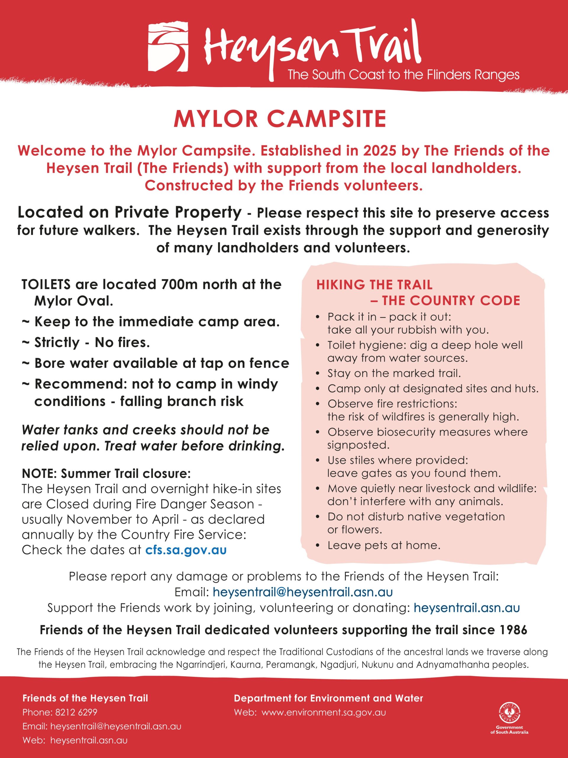
Camping on the Heysen Trail

camping-on-the-heysen-trail-IMG_5370
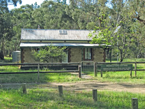
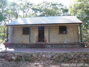
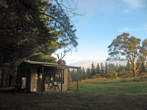
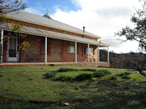
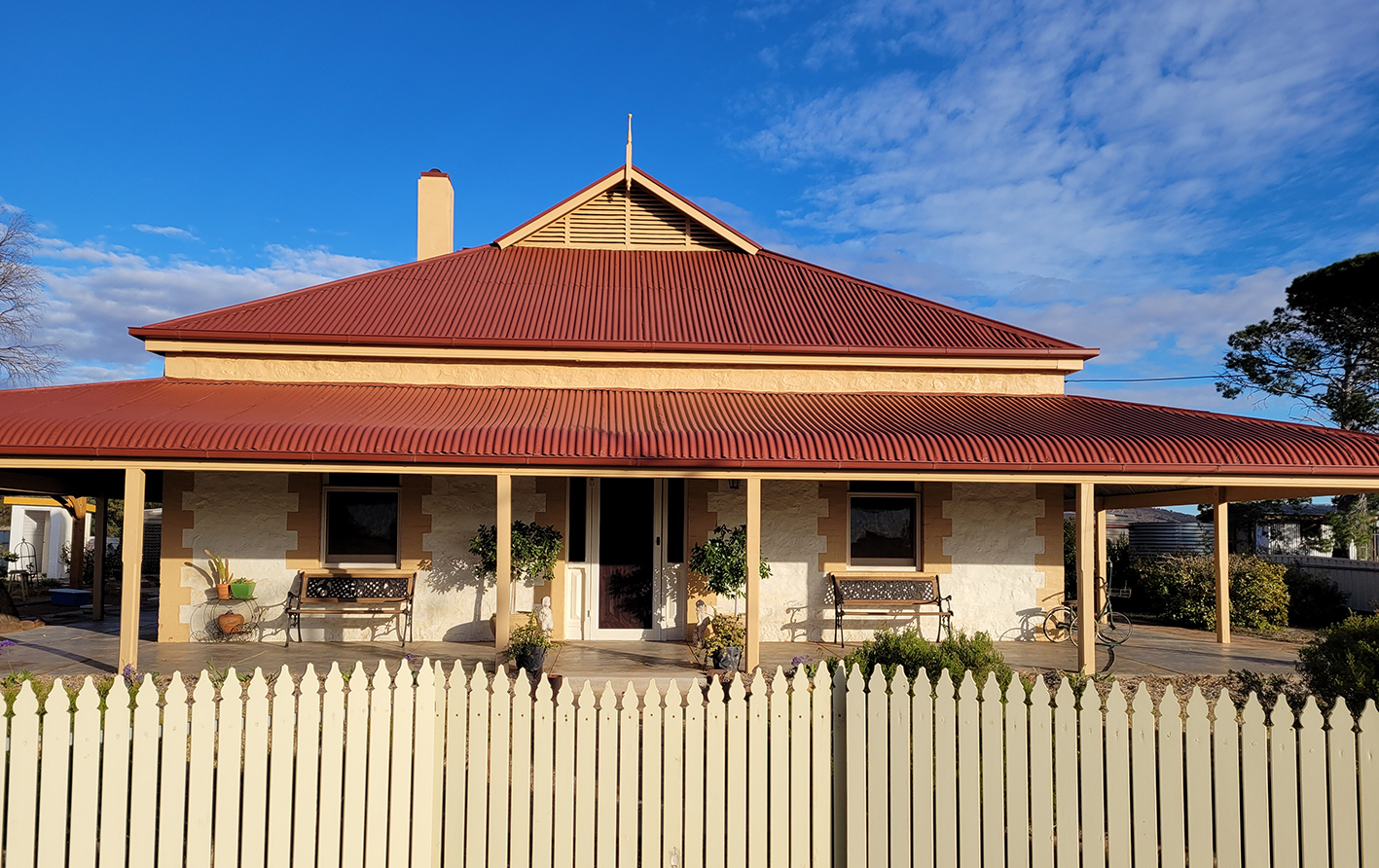
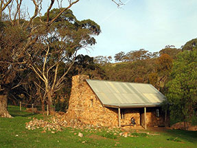
Huts vary from either stone or timber settler’s cottages and old public buildings. Water is available at most, but not all, campsites and huts. Specific detailed information about each campsite, shelter and hut is available below. Most of the huts are basic, offering only a small sleeping shelter with a rainwater tank. Walkers should aim to be self-reliant. The huts incorporate facilities such as a rainwater tank, simple bunks, toilet, fireplace, tables and seats.

Generally there are no fees for using the huts and shelters. Most huts cannot be pre-booked or reserved, so you are advised to carry a tent in case they are fully occupied upon your arrival.

Huts and campsites in national parks and forests incur a fee and need to be booked on-line in advance. Most huts and campsites in forests need to be booked in advance.
Refer to the booking instructions for these sites in the Accommodation listing below.

Private campsites such as caravan parks require payment.
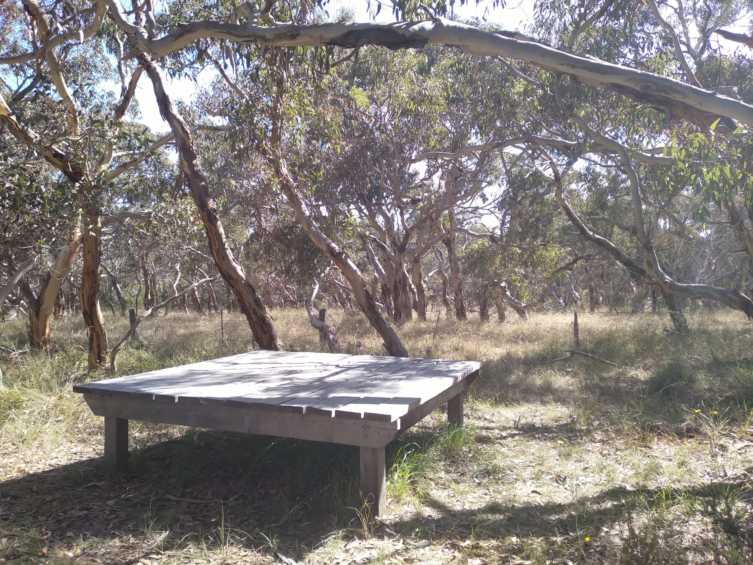
‘Walk-in’ sites

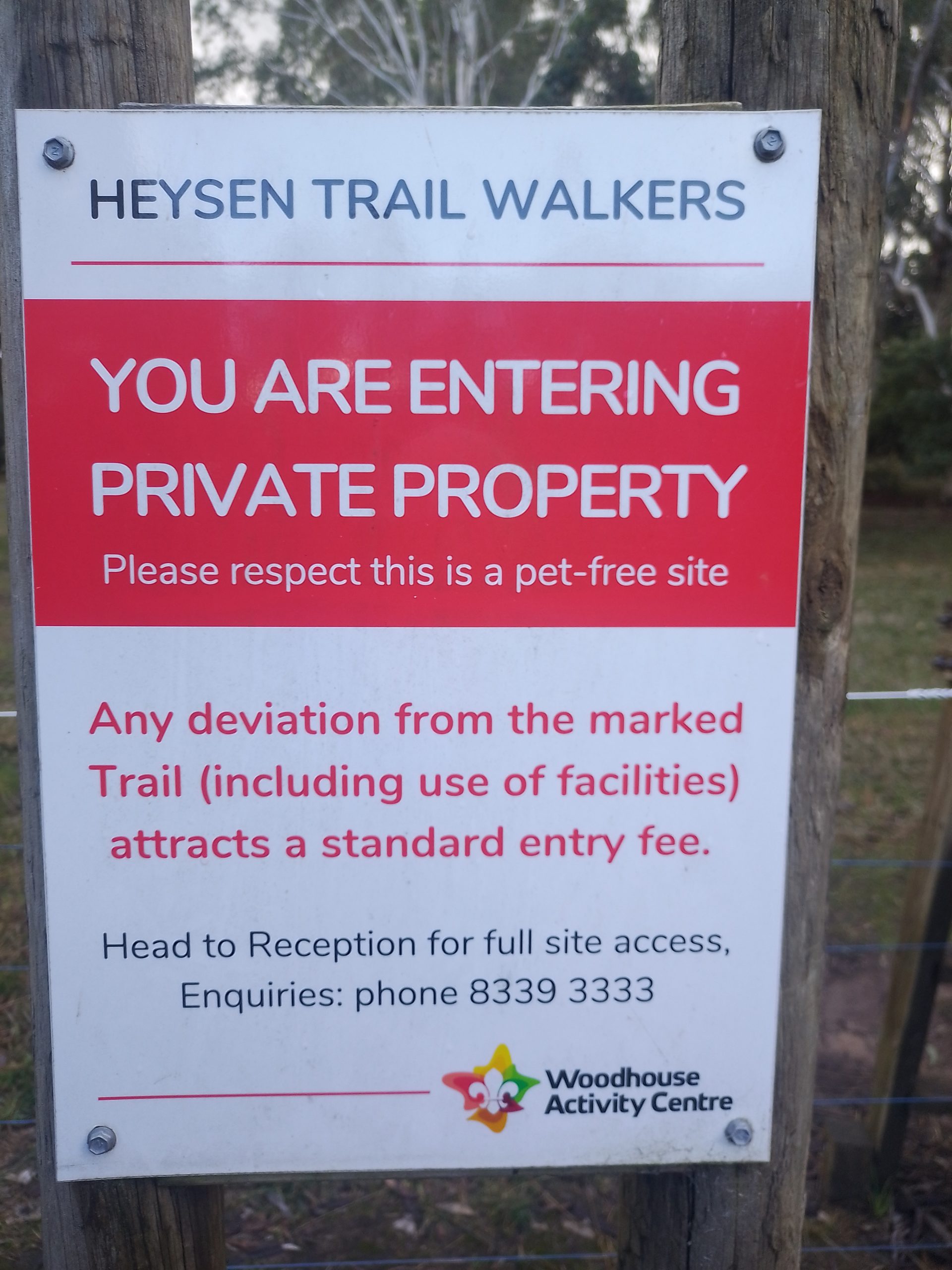
The Accommodation list includes over 40 locations classified as ‘Walk-in’ sites. These locations are generally on private property or Crown land (including some in national or conservation parks). The sites are on the trail and not accessible by motor vehicle.  As such require walkers need to carry in a tent and other camping equipment.

Shelters

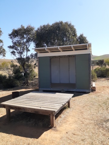
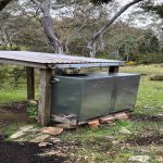
Many of the shelters are primarily constructed to capture rainwater rather than provide sufficient space to sleep – these are noted as small shelters.

Medium and large shelters usually have three walls with one open side, suitable for sleeping during inclement weather.

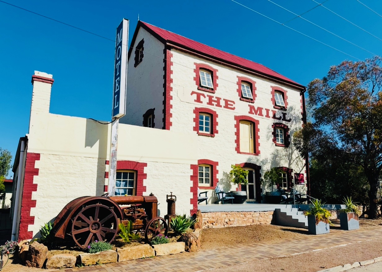
Caravan Parks, Hotels, Motels, B&Bs and Self-Contained Cottages

There are many commercial accommodation options available near the trail, or in towns the trail passes through or near to. Information about many of these is provided below.
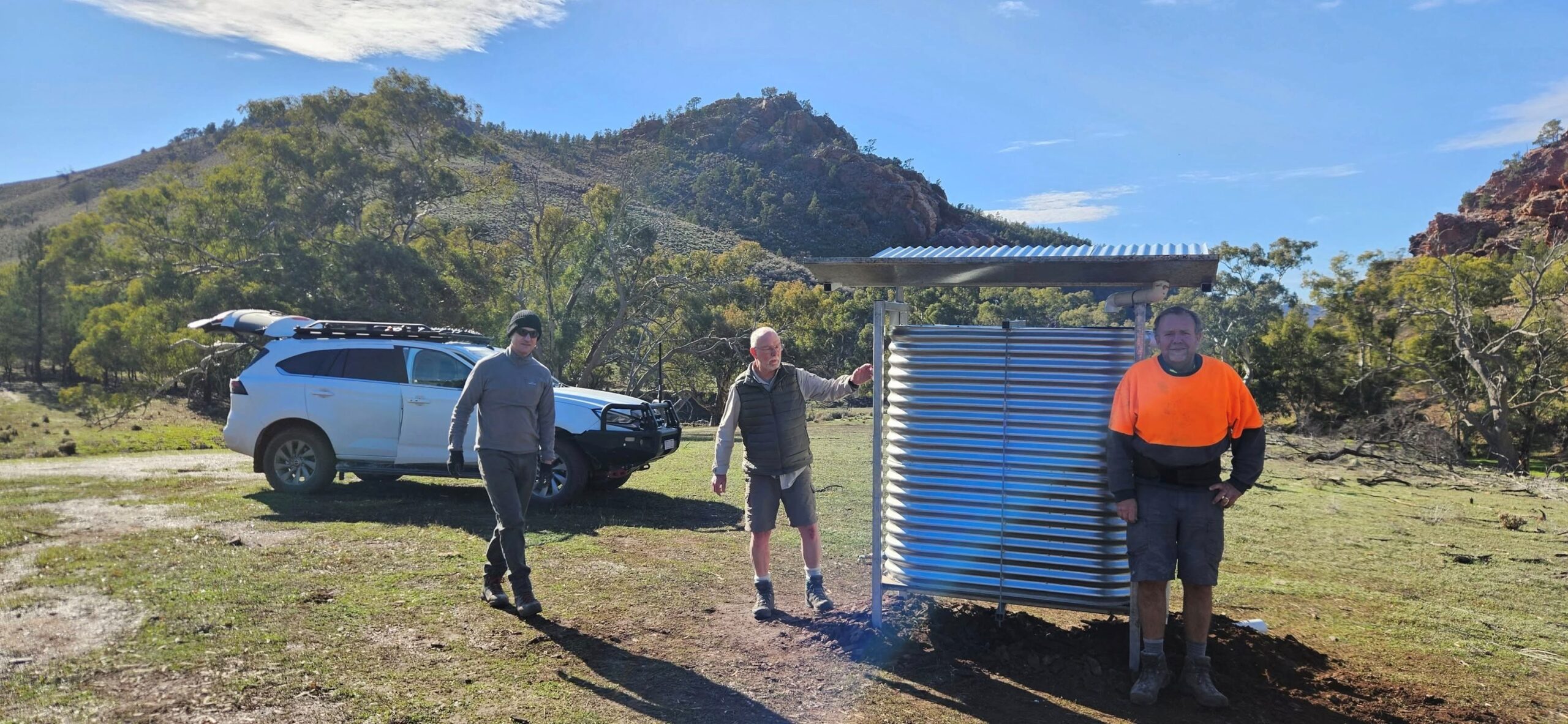
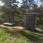
Rain water tanks

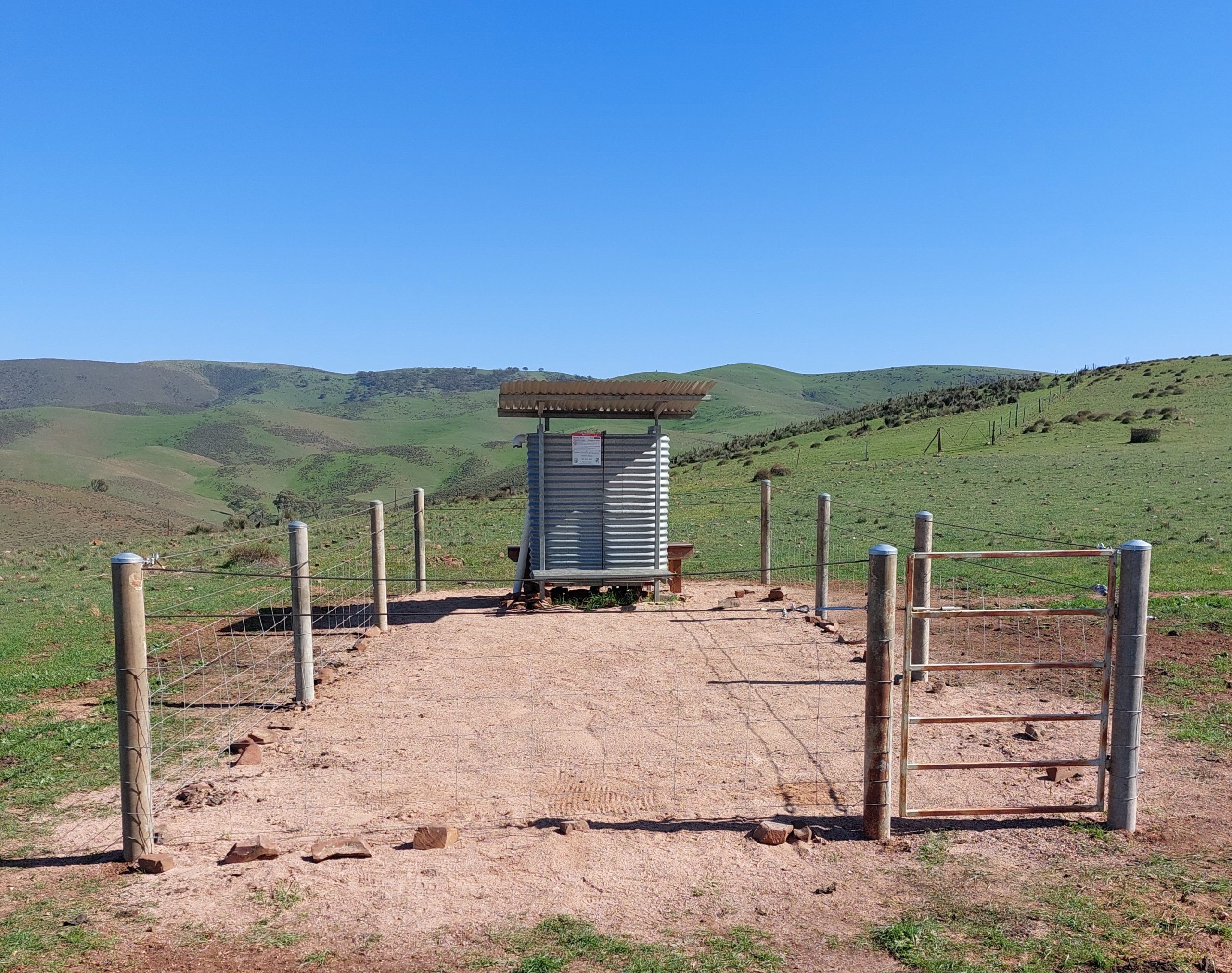
There are over 80 ‘Water tanks’ (at campsites and ‘walk-in’ sites) and ‘Water only locations’ along the trail. Due to remote location of some of the tanks and the dry summers, particularly in the northern regions, water supplies can be unreliable.

Walkers, especially through walkers, need to be aware that water and its quality cannot be guaranteed along the Trail. You can check the latest reports of water levels by checking Water Tank Levels page.

Walkers are encouraged to report the level of water held in tanks. You can help other walkers and our Office Volunteers keep a track of water supplies. Tell us about tank water levels and quality using this link to our Report a Tank Level page. You can select the tank site using a ‘drop down’ list of tanks.

Whilst we endeavour to have up to date information on water levels on all our tanks, due to the remote location of some, this is not always possible.

We also recommend that you treat the water before drinking.

In addition to these resources, water can also be obtained in towns.

Search Accommodation Options

Accommodation options along the Heysen Trail include campsites, huts, shelters, caravan parks, hotels and bed & breakfasts.

Listed Huts, Campsites and Towns

This comprehensive list of huts, campsites and town accommodation options provides up-to-date information. The official Mapsheets mark each hut and campsite on the maps, but information about each can be limited, and sometimes campsites are closed, altered or upgraded, and that information is reflected below.

The below information can also be viewed via the Interactive Map of the Heysen Trail by selecting the Accommodation checkbox.

Displaying 143 results

Cape Jervis

Accommodation
Town
Mapsheet
1A
Coordinates
Grid ref: 375 559
Longitude: 138.106873
Latitude: -35.603771
Download
Download GPX file for a GPS unit
Download KML file for Google Earth/Maps

Displaying 2 accommodation options in this town

Cape Jervis Accommodation & Caravan Park

Accommodation
B&B,
Campsite,
Caravan Park,
Self contained unit/house
Location

9351 Main S Rd, Cape Jervis SA 5204

Coordinates
Grid ref: 397 560
Longitude: 138.129264
Latitude: -35.605685
Download
Download GPX file for a GPS unit
Download KML file for Google Earth/Maps
Facilities

Self contained cottage, bed & breakfast, budget accommodation, caravan & camping

Cobbler Hill Camp Site

2 additional photos and 2 comments on
heysentrail.asn.au/?p=1660
Accommodation
Campsite,
Water Tank
Water Tank Level

View latest reported tank level.

Report the tank level.

Mapsheet
1A
Location
Deep Creek National Park
Coordinates
Grid ref: 441 515
Longitude: 138.173508
Latitude: -35.647533
Download
Download GPX file for a GPS unit
Download KML file for Google Earth/Maps
Bookings

Self registrations stations no longer available for this park.
Book on line at : https://www.parks.sa.gov.au/booking/details#/accom/73176

Cash payments can be made at:

Yankalilla
Fleurieu Coast Information Centre
Address: 163 Main South Road Yankalilla SA 5203
Phone: 1300 965 842

Fees

Fees apply

Facilities

shelter, water, fireplaces, toilet

Notes

Occasionally access to the Park may be restricted. Refer to the National Park SA Park Alerts webpage to check whether there are any current restrictions for Deep Creek National Park. https://www.parks.sa.gov.au/know-before-you-go/closures-and-alerts

Wuldi Krikin Ngawanthi / Eagle Waterhole ‘walk-in’ site

The shelter exterior view
4 additional photos and 1 comment on
heysentrail.asn.au/?p=1659
Accommodation
Shelter (medium),
'Walk-in' site,
Water Tank
Water Tank Level

View latest reported tank level.

Report the tank level.

Mapsheet
1A
Location
Deep Creek National Park
Coordinates
Grid ref: 458 516
Longitude: 138.1924167
Latitude: -35.64685
Download
Download GPX file for a GPS unit
Download KML file for Google Earth/Maps
Bookings

Self registrations stations no longer available for this park.
Book on line at :
https://www.parks.sa.gov.au/experiences/wscw/book-now

All camping booking enquiries
Victor Harbor National Parks and Wildlife Service Office
Phone: (+61 8) 8552 0300
Email: DEW.FleurieuOnlineBookings@sa.gov.au

Fees

This camp-site is part of the Wild South Coast Way.
Fees apply and you must book in advance. Book before you go.
If you are leaving a vehicle in Deep Creek National Park overnight you must pay a vehicle day entry fee for each day you are in the park.

Facilities

10 x timber or compacted earth tent pads;
shelter with seating, bench and sink with untreated rainwater;
waterless toilets;
rainwater tanks (non-potable).
(NB the supply is monitored and topped up as necessary by the park rangers)

Notes

The updated Wuldi Krikin Ngawanthi / Eagle Waterhole Campground was opened in April 2022.

Occasionally access to the Park may be restricted. Refer to the National Park SA Park Alerts webpage to check whether there are any current restrictions for Deep Creek National Park.
https://www.parks.sa.gov.au/know-before-you-go/closures-and-alerts

Goondooloo Cottage

Goondooloo Cottage
Accommodation
Self contained unit/house
Mapsheet
1A
Location
Located 2km off the trail, at trailhead of the Aaron Creek Trail, on Blowhole Beach Road, Deep Creek National Park
Coordinates
Grid ref: 460534
Longitude: 138.1961
Latitude: -35.6303
Download
Download GPX file for a GPS unit
Download KML file for Google Earth/Maps
Contact

Southern Ocean Retreats
https://southernoceanretreats.com.au/goondooloo-cottage/
Jane Formato & Barry Duykers (+61 8) 8598 4169

Bookings

Yes

Fees

Yes

Facilities

Self contained cottage

Trig Campground

A campsite
1 additional photo and 1 comment on
heysentrail.asn.au/?p=1658
Accommodation
Campsite,
Shelter (medium),
Water Tank
Water Tank Level

View latest reported tank level.

Report the tank level.

Mapsheet
1A
Location
Deep Creek National Park
Coordinates
Grid ref: 477 511
Longitude: 138.216919
Latitude: -35.652607
Download
Download GPX file for a GPS unit
Download KML file for Google Earth/Maps
Bookings

Self registrations stations no longer available for this park. Book on line at : https://www.parks.sa.gov.au/booking/details#/accom/73170

Cash payments can be made at:

Yankalilla
Fleurieu Coast Information Centre
Address: 163 Main South Road Yankalilla SA 5203
Phone: 1300 965 842
"

Fees

Fees apply for this location.

Facilities

camp site, shelter at picnic area, water, fireplaces, toilet

Notes

Occasionally access to the Park may be restricted. Refer to the National Park SA Park Alerts webpage to check whether there are any current restrictions for Deep Creek National Park. https://www.parks.sa.gov.au/know-before-you-go/closures-and-alerts

Yapari Ngawanthi / Cliffs ‘walk-in’ site

The shelter
4 additional photos and 1 comment on
heysentrail.asn.au/?p=131822
Accommodation
Shelter (medium),
'Walk-in' site,
Water Tank
Water Tank Level

View latest reported tank level.

Report the tank level.

Mapsheet
1A
Location
Deep Creek National Park
Coordinates
Grid ref: 516 535
Longitude: 138.257613592
Latitude: -35.630357936
Download
Download GPX file for a GPS unit
Download KML file for Google Earth/Maps
Contact
Bookings

Book on line at :
https://www.parks.sa.gov.au/experiences/wscw/book-now

All camping booking enquiries
Victor Harbor National Parks and Wildlife Service Office
Phone: (+61 8) 8552 0300
Email: DEW.FleurieuOnlineBookings@sa.gov.au

Fees

This camp-site is part of the Wild South Coast Way.
Fees apply and you must book in advance. Book before you go.
If you are leaving a vehicle in Deep Creek National Park overnight you must pay a vehicle day entry fee for each day you are in the park.

Facilities

10 x timber or compacted earth tent pads;
shelter with seating, bench and sink with untreated rainwater;
waterless toilets;
rainwater tanks (non-potable).
(NB the supply is monitored and topped up as necessary by the park rangers)

History

The new Yapari Ngawanthi / Cliffs Campground was opened in April 2022.

Notes

The new Yapari Krikin Ngawanthi / Cliffs Campground was opened in April 2022.

Tapanappa Camp Site

A campsite
1 additional photo on
heysentrail.asn.au/?p=1657
Accommodation
Campsite,
Water Tank
Water Tank Level

View latest reported tank level.

Report the tank level.

Mapsheet
1A
Location
Deep Creek National Park
Coordinates
Grid ref: 518 532
Longitude: 138.259857
Latitude: -35.633266
Download
Download GPX file for a GPS unit
Download KML file for Google Earth/Maps
Bookings

Self registrations stations no longer available for this park. Book on line at : https://www.parks.sa.gov.au/booking/details#/accom/73174

Cash payments can be made at:

Yankalilla
Fleurieu Coast Information Centre
Address: 163 Main South Road Yankalilla SA 5203
Phone: 1300 965 842

Fees

Fees apply to this location.

Facilities

camp site, water, fireplaces, toilet

Notes

Occasionally access to the Park may be restricted. Refer to the National Park SA Park Alerts webpage to check whether there are any current restrictions for Deep Creek National Park. https://www.parks.sa.gov.au/know-before-you-go/closures-and-alerts

Kurri Ngawanthi / Creek ‘walk in’ site

The updated Kurri Ngawanthi / Creek 'walk-in' site in April 2022.
5 additional photos and 12 comments on
heysentrail.asn.au/?p=1697
Accommodation
Shelter (medium),
'Walk-in' site,
Water Tank
Water Tank Level

View latest reported tank level.

Report the tank level.

Mapsheet
1B
Location
Ballaparudda Creek Recreation Park
Coordinates
Grid ref: 641 554
Longitude: 138.3955304769
Latitude: -35.6165758726
Download
Download GPX file for a GPS unit
Download KML file for Google Earth/Maps
Bookings

Book on line at :
https://www.parks.sa.gov.au/experiences/wscw/book-now

All camping booking enquiries
Victor Harbor National Parks and Wildlife Service Office
Phone: (+61 8) 8552 0300
Email: DEW.FleurieuOnlineBookings@sa.gov.au

Fees

This camp-site is part of the Wild South Coast Way.
Fees apply and you must book in advance. Book before you go.
If you are leaving a vehicle in Deep Creek National Park overnight you must pay a vehicle day entry fee for each day you are in the park.

Facilities

10 x timber or compacted earth tent pads;
shelter with seating, bench and sink with untreated rainwater;
waterless toilets;
rainwater tanks (non-potable).
(NB the supply is monitored and topped up as necessary by the park rangers)

History

The updated Kurri Ngawanthi / Creek 'walk-in' site was opened in April 2022.
Located in the newly proclaimed park, Ballaparudda Recreation Park, this is a significant upgrade to the former Balquhidder camp site which did not previously attract a camping fee.

Waitpinga camp site

Campsite
4 additional photos and 7 comments on
heysentrail.asn.au/?p=1651
Accommodation
Campsite,
Hut,
Shelter (large),
Water Tank
Water Tank Level

View latest reported tank level.

Report the tank level.

Mapsheet
1B
Location
Newland Head Conservation Park
Coordinates
Grid ref: 736 542
Longitude: 138.499863
Latitude: -35.627735
Download
Download GPX file for a GPS unit
Download KML file for Google Earth/Maps
Bookings

Self registrations stations no longer available for this park. Book on line at :
https://www.parks.sa.gov.au/booking/details#/accom/73191

Fees

Yes

Facilities

Camp site, hut and shelter at picnic area, water, toilet.
Note - wood & solid fuel fires are prohibited in Newland Head Conservation Park (including Waitpinga campground).

Notes

Occasionally access to the Park may be restricted. Refer to the National Park SA Park Alerts webpage to check whether there are any current restrictions for Newland Head Conservation Park. https://www.parks.sa.gov.au/know-before-you-go/closures-and-alerts

Natunyuru Ngawanthi / Sand Dunes ‘walk-in’ camp site

Shelter exterior view
2 additional photos and 4 comments on
heysentrail.asn.au/?p=131830
Accommodation
Shelter (medium),
'Walk-in' site,
Water Tank
Water Tank Level

View latest reported tank level.

Report the tank level.

Mapsheet
1B
Location
Newland Head Conservation Park
Coordinates
Grid ref: 745 546
Longitude: 138.509961
Latitude: -35.626415
Download
Download GPX file for a GPS unit
Download KML file for Google Earth/Maps
Contact

Deep Creek National Park headquarters, phone (+61 8) 8598 0263

Bookings

Book on line at :
https://www.parks.sa.gov.au/experiences/wscw/book-now

All camping booking enquiries
Victor Harbor National Parks and Wildlife Service Office
Phone: (+61 8) 8552 0300
Email: DEW.FleurieuOnlineBookings@sa.gov.au

Fees

This camp-site is part of the Wild South Coast Way.
Fees apply and you must book in advance. Book before you go.
If you are leaving a vehicle in Deep Creek National Park overnight you must pay a vehicle day entry fee for each day you are in the park.

Facilities

10 x timber or compacted earth tent pads;
shelter with seating, bench and sink with untreated rainwater;
waterless toilets;
rainwater tanks (non-potable).
(NB the supply is monitored and topped up as necessary by the park rangers)

History

The Natunyuru Ngawanthi / Sand Dunes Campground was first opened in April 2022

Kings Beach Road trailhead (Victor Harbor 5 km east)

Accommodation
Other
Mapsheet
1B
Coordinates
Grid ref: 812578
Longitude: 138.584310
Latitude: -35.598755
Download
Download GPX file for a GPS unit
Download KML file for Google Earth/Maps
Notes

Walking from the direction of Cape Jervis:
1. Wild South Coast Way continues east from this junction towards Victor Harbor. Victor Harbor is 5km east of the junction.
2. The Heysen Trail proper continues northwards along Kings Beach Road.

Robinson Hill ‘walk-in’ site

Camping platform.
3 additional photos and 11 comments on
heysentrail.asn.au/?p=1706
Accommodation
Shelter (small),
'Walk-in' site,
Water Tank
Water Tank Level

View latest reported tank level.

Report the tank level.

Mapsheet
1C
Location
300m west of the junction of Keens, Handcock and Prouse Roads.
Coordinates
Grid ref: 720 666
Longitude: 138.4857402522
Latitude: -35.5173318913
Download
Download GPX file for a GPS unit
Download KML file for Google Earth/Maps
Contact

https://www.heysentrail.asn.au (Friends of the Heysen Trail)

Bookings

No

Fees

None

Facilities

Campsite, shelter (seating only) with water tank, toilet, small platform.
NOTE : No fires are permitted at this site - Only fuel stoves are permitted.
Fire Danger Season - this walk in-site is closed during CFS Fire Danger Season
(Check dates that vary annually between October & May at https://cfs.sa.gov.au/warnings-restrictions/restrictions/fire-danger-season-dates-permits/#dates )

History

Walk-in site established in December 2011.
Shelter and water tank completed in early 2012.
Toilet constructed 2014.

Photos of the construction of the shelter & water tank from December 2011: https://picasaweb.google.com/115827045141699129695/RobinsonHill?authuser=0&feat=directlink#

Notes

A new campsite established in December 2011. Shelter and water tank completed in early 2012. Toilet constructed 2014.

Inman Valley

2 additional photos and 1 comment on
heysentrail.asn.au/?p=1648
Accommodation
Town
Mapsheet
1C
Coordinates
Longitude: 138.458313
Latitude: -35.493382
Download
Download GPX file for a GPS unit
Download KML file for Google Earth/Maps

Displaying 1 accommodation option in this town

Inman Valley town campsite

Accommodation
Campsite,
Water Tank
Location

1713 Inman Valley Rd, Inman Valley.
Adjacent to the Inman Valley Memorial Hall and across the road from the Inman Valley General Store.

Coordinates
Grid ref: 694 692
Longitude: 138.457744
Latitude: -35.493793
Download
Download GPX file for a GPS unit
Download KML file for Google Earth/Maps
Contact

Inman Valley Community and Memorial Hall Association:
ivmemorialhall@gmail.com

Facilities

Tent pad near toilet block, water tank.

Heysen’s Rest Bed & Breakfast

Accommodation
Self contained unit/house
Mapsheet
1C
Location
45 Nunn Rd, Myponga, on the Heysen Trail
4.5 km south west of Myponga.
Coordinates
Grid ref: 677 776
Longitude: 138.4382
Latitude: -35.4189
Download
Download GPX file for a GPS unit
Download KML file for Google Earth/Maps
Contact

http://www.heysensrest.com.au
Mobile (+61) 0499 629 252
info@heysensrest.com.au

Bookings

Yes

Fees

Yes.

Facilities

There are 2 self-contained cabins equipped with a basic kitchen, fridge, TV, air-conditioning and en-suite bathroom.
Current rates to be confirmed.

A recent development has added four single lodgings which are perfect for walkers.
Include air-conditioning, TV, ensuite & fridge. ,

Mt Cone Tank (Water Location Only)

Accommodation
Water only location
Water Tank Level

View latest reported tank level.

Report the tank level.

Mapsheet
1C
Location
Located in a small reserve above a Y road junction.
Coordinates
Grid ref: 784 803
Longitude: 138.5605230305
Latitude: -35.3951773502
Download
Download GPX file for a GPS unit
Download KML file for Google Earth/Maps
Contact

Friends of the Heysen Trail

Bookings

No

Fees

None

Facilities

Shelter (seating only) with water tank.

Camping is not permitted here.

History

Photos of the construction of the shelter & water tank from December 2011: https://picasaweb.google.com/115827045141699129695/MountCone?authuser=0&feat=directlink#

Notes

A new facility established in December 2011. Shelter and water tank completed in early 2012.

Mt Compass

Accommodation
Town
Mapsheet
1D
Coordinates
Grid ref: 837 856
Longitude: 138.621155
Latitude: -35.348831
Download
Download GPX file for a GPS unit
Download KML file for Google Earth/Maps

Displaying 1 accommodation option in this town

Woodcutters Cottage (formerly Old Kuitpo Youth Hostel)

Accommodation
Hut,
Self contained unit/house,
Water Tank
Water Tank Level

View latest reported tank level.

Report the tank level.

Mapsheet
1D
Location
Kuitpo Forest
Coordinates
Grid ref: 984 992
Longitude: 138.685147
Latitude: -35.229886
Download
Download GPX file for a GPS unit
Download KML file for Google Earth/Maps
Contact

Kuitpo Forest Information Centre
Open 10am-12pm on Fri, Sat, Sun (subject to ranger availability)
Phone: (+61 8) 8391 8800 between 9am – 4pm, Monday to Friday
Email: recreation@forestrysa.com.au
Website: https://www.forestrysa.com.au/contact/

Bookings

Minimum 2 night stay
Overnight bookings are available between 1 April and 30 November.
Day bookings are available between 1 December and 31 March

https://bookings2.rms.com.au/obookings3/Search/Index/13419/1/1

Fees

From July 1, 2024 the applicable fees are...
$145.00 per day / night (all inclusive)
(The fees are reviewed at the end of each financial year)

Facilities

2 km from the information centre on Brookman Road (Meadows to Willunga Road). Formerly the Youth Hostel this four room stone cottage, with solar- powered lighting; Two bedrooms, sleeping up to 11 people on five bunk beds (linen not supplied) ; Kitchen with gas cooking, sink, table and chairs (cutlery, crockery and cooking equipment not supplied) ; Lounge Room with slow combustion wood heater and chairs ; Verandah ; Picnic table ; Fire pit ; Rainwater (not suitable for drinking) ; Toilet ; Four horse yards
Maximum occupancy in the exclusive-use area is 20. Booking relates to facility and immediate vicinity of the venue & around designated fire pit only.

Notes

Please note that in addition to fire bans applicable to the Mount Lofty Ranges Region, special fire restrictions apply to ForestrySA accommodation and campsites.
Provided that a Total Fire Ban has not been imposed by the Country Fire Service (CFS):
Wood fires are permitted within the forest from 1 May to 31 October each year.
Gas fires are permitted from 1 April to 30 November.
Fireplaces should be cleared of all flammable material for a distance of 4 metres. Someone must be always present and ensure that the fire is fully extinguished before leaving.
Forests are very sensitive to fire, so please ensure all restrictions are followed.
Occasionally access to Forest Reserves may be restricted. Refer to https://www.forestrysa.com.au/before-you-visit/forest-closures-and-alerts/ for forest closure information.

Chookarloo Campground

Accommodation
Campsite,
Water Tank
Water Tank Level

View latest reported tank level.

Report the tank level.

Mapsheet
2A
Location
Kuitpo Forest
Coordinates
Grid ref: 918 016
Longitude: 138.714981
Latitude: -35.203808
Download
Download GPX file for a GPS unit
Download KML file for Google Earth/Maps
Contact

Kuitpo Forest Information Centre
Open 10am-12pm on Fri, Sat, Sun (subject to ranger availability)
Phone: (+61 8) 8391 8800 between 9am – 4pm, Monday to Friday
Email: recreation@forestrysa.com.au
Website: https://www.forestrysa.com.au/contact/

Bookings

Camping is permitted from 1 April to 30 November annually, outside of the fire danger season.
Fees apply for camping at Chookarloo.
Two campsites are reserved for hikers ... to book these contact Forestry SA on (+61 8) 8391 8800 during normal office hours.
To book any of the other sites use this link: https://www.forestrysa.com.au/camping/chookarloo-campground/

Fees

Refer to the on-line booking system for information about camping fees. Payment is required at the time of booking.

From July 1, 2024 the applicable fees are...
Camping...
$20.30 per vehicle, per campsite
Adult $7.90, Child $4.55 (walk-in / ride-in only)
(The fees are reviewed at the end of each financial year)

Facilities

shelter, water, fireplaces, tables, seating, toilet

Notes

Please note that in addition to fire bans applicable to the Mount Lofty Ranges Region, special fire restrictions apply to ForestrySA accommodation and campsites.
Provided that a Total Fire Ban has not been imposed by the Country Fire Service (CFS):
Wood fires are permitted within the forest from 1 May to 31 October each year.
Gas fires are permitted from 1 April to 30 November.
Fireplaces should be cleared of all flammable material for a distance of 4 metres. Someone must be always present and ensure that the fire is fully extinguished before leaving.
Forests are very sensitive to fire, so please ensure all restrictions are followed.
Occasionally access to Forest Reserves may be restricted. Refer to https://www.forestrysa.com.au/before-you-visit/forest-closures-and-alerts/ for forest closure information.

Rocky Creek Hut & ‘Walk in’ site

1 additional photo and 7 comments on
heysentrail.asn.au/?p=1642
Accommodation
Hut,
'Walk-in' site,
Water Tank
Water Tank Level

View latest reported tank level.

Report the tank level.

Mapsheet
2A
Location
Kuitpo Forest
Coordinates
Grid ref: 938 083
Longitude: 138.738724
Latitude: -35.146038
Download
Download GPX file for a GPS unit
Download KML file for Google Earth/Maps
Contact

Kuitpo Forest Information Centre
Open 10am-12pm on Fri, Sat, Sun (subject to ranger availability)
Phone: (+61 8) 8391 8800 between 9am – 4pm, Monday to Friday
Email: recreation@forestrysa.com.au
Website: https://www.forestrysa.com.au/contact/

Bookings

Camping...
Camping is permitted from 1 April to 30 November annually, outside of the fire danger season.
Book on line - https://www.forestrysa.com.au/camping/rocky-creek-campground/

Hut...
Minimum 2 night stay
Hut booking is for the hut and the immediate vicinity in front of the hut, around the designated fire pit only
Overnight bookings are available between 1 April and 30 November.
Day bookings are available between 1 December and 31 March
On line bookings: https://www.forestrysa.com.au/Recreation/Accommodation/Rocky-Creek-Hut.

Fees

Refer to the on-line booking system for information about camping fees. Payment is required at the time of booking.

From July 1, 2024 the applicable fees are...
Campground...
Adult $7.90, Child $4.55 (walk-in / ride-in only - no vehicle access)

Hut...
from $102.00 per day / night
(The fees are reviewed at the end of each financial year)

Facilities

Camping...
Unpowered site
Maximum of 2 guests per booking
Rocky Creek Campground accommodates up to 16 hikers in total.
Distance from amenities: 200m from toilet facilities shared with Rocky Creek Hut
No vehicle access
Wood fires permitted in designated communal fire pit only

Hut...
Rocky Creek Hut sleeps 5 people. Maximum occupancy in this exclusive-use area is 10 people
One room cottage, accommodating up to five people on two wooden platforms (linen not supplied)
Small food preparation area with sink (crockery, cutlery and cooking equipment not supplied)
Internal slow combustion wood heater
Solar lighting inside and outside.
Rainwater (not suitable for drinking)
Toilet
Fire pit
Solar lighting inside and out
Veranda
Two picnic tables

Detailed info from Forestry SA: https://www.forestrysa.com.au/accommodation/rocky-creek-hut/

Notes

Please note that in addition to fire bans applicable to the Mount Lofty Ranges Region, special fire restrictions apply to ForestrySA accommodation and campsites.
Provided that a Total Fire Ban has not been imposed by the Country Fire Service (CFS):
Wood fires are permitted within the forest from 1 May to 31 October each year.
Gas fires are permitted from 1 April to 30 November.
Fireplaces should be cleared of all flammable material for a distance of 4 metres. Someone must be always present and ensure that the fire is fully extinguished before leaving.
Forests are very sensitive to fire, so please ensure all restrictions are followed.
Occasionally access to Forest Reserves may be restricted. Refer to https://www.forestrysa.com.au/before-you-visit/forest-closures-and-alerts/ for forest closure information.

Mylor

Accommodation
Town
Mapsheet
2A
Coordinates
Longitude: 138.760079
Latitude: -35.0422
Download
Download GPX file for a GPS unit
Download KML file for Google Earth/Maps

Displaying 1 accommodation option in this town

Woodhouse Activity Centre

Accommodation
Campsite,
Other,
Water Tank
Mapsheet
2B
Location
Woodhouse Scout Campsite
37 Spring Gully Road, Piccadilly
Coordinates
Grid ref: 935 260
Longitude: 138.737366
Latitude: -34.986656
Download
Download GPX file for a GPS unit
Download KML file for Google Earth/Maps
Fees

Yes.

Facilities

toilets & showers, water. bunk house and chalet also available

Mt Lofty Summit cafe

Mt Lofty Summit
Accommodation
Other,
Water Tank
Mapsheet
2B
Location
Cleland National Park
Coordinates
Grid ref: 908 274
Longitude: 138.708992
Latitude: -34.974113
Download
Download GPX file for a GPS unit
Download KML file for Google Earth/Maps
Facilities

Cafe, Toilets, Town Water, Visitor Information Centre.
View facilities at https://www.heysentrail.asn.au/heysen_trail/service_directory.php#mount_lofty

Cleland Cottage (formerly Mt Lofty Cottage YHA)

Accommodation
Self contained unit/house
Mapsheet
2B
Location
Gate 25, Summit Road, Crafers, in the Cleland National Park
Located within walking distance to Mount Lofty Summit and Cleland Wildlife Park.
Coordinates
Grid ref: 905 273
Longitude: 138.706223
Latitude: -34.974304
Download
Download GPX file for a GPS unit
Download KML file for Google Earth/Maps
Fees

$185/night (as at 21/7/2025)

Facilities

Cottage sleeps up to ten people in three bedrooms (two queens and three sets of bunks). The cottage is self-contained with crockery, cutlery, cooking utensils, pots & pans supplied. Bring your own sheets, pillows, blankets and towels.
There are 2 water tanks but they behind a padlocked gate and are not accessible to the public.

History

Originally built as a two-roomed hut, probably to accommodation shepherds working for Arthur Hardy or Sir Samuel Davenport. Hardy and Davenport were two of the first large estate landowners on this side of Mount Lofty Summit. They used the land chiefly for pastoralism and logging but also some agriculture, including the growing of vines and olives. Hardy was the first 'colonial gentleman' to build a summer house on Mount Lofty - nearby Mount Lofty House in the 1850s.

Notes

Update July 2025 - Parks SA has advised the property is secured with a combination padlock. The combination is sent by email through the Parks on-line booking system.
The previous arrangement of collecting a key from Belair is no longer applicable.

Cudlee Creek North ‘walk-in’ site (Grandpa’s)

1 additional photo and 11 comments on
heysentrail.asn.au/?p=1633
Accommodation
Shelter (small),
'Walk-in' site,
Water Tank
Water Tank Level

View latest reported tank level.

Report the tank level.

Mapsheet
2C
Location
Mount Crawford Forest
Coordinates
Grid ref: 009 395
Longitude: 138.822601
Latitude: -34.866856
Download
Download GPX file for a GPS unit
Download KML file for Google Earth/Maps
Bookings

Yes. Commencing with 2023 Walk Season Heysen Hikers need to book this site for an overnight stop. Please call ForestrySA on (+61 8) 8391 8800 between 9-4pm Monday to Friday. As this is a new process FSA understands that some hikers may not be aware but Rangers will monitor sites to assist in educating hikers. For urgent afterhours issues requiring a ranger, please call (+61 8) 8391 8800 and press # 2.

Notes: Bookings are required to gain a camping permit to stay in the forest overnight. These sites are not suitable for large groups but bookings may be made by more than 1 hiker per night recognising that tents may be used as well as bunks in huts.

Fees

No

Facilities

Bush campsite, fire pit, stone table, walker's platform, small shelter (complete with logbook), rainwater tank, large flat camping area up from the fire pit.

History

Area surrounding Grandpas was badly damaged during the December 2019 Cudlee Creek bushfire.
Forestry SA reopened the area in May 2021.

Notes

Cudlee Creek

1 additional photo on
heysentrail.asn.au/?p=1632
Accommodation
Town
Mapsheet
2C
Location
Gorge Road, Cudlee Creek
Coordinates
Grid ref: 003 424
Longitude: 138.81665
Latitude: -34.839745
Download
Download GPX file for a GPS unit
Download KML file for Google Earth/Maps

Displaying 1 accommodation option in this town

Scotts Shelter

2 additional photos and 15 comments on
heysentrail.asn.au/?p=1630
Accommodation
Shelter (medium),
'Walk-in' site,
Water Tank
Water Tank Level

View latest reported tank level.

Report the tank level.

Mapsheet
2C
Location
Mt Crawford Forest
Coordinates
Grid ref: 084 516
Longitude: 138.906659
Latitude: -34.759902
Download
Download GPX file for a GPS unit
Download KML file for Google Earth/Maps
Bookings

Yes. Commencing with 2023 Walk Season Heysen Hikers need to book this site for an overnight stop. Please call ForestrySA on (+61 8) 8391 8800 between 9-4pm Monday to Friday. As this is a new process FSA understands that some hikers may not be aware but Rangers will monitor sites to assist in educating hikers. For urgent afterhours issues requiring a ranger, please call (+61 8) 8391 8800 and press # 2.

Notes: Bookings are required to gain a camping permit to stay in the forest overnight. These sites are not suitable for large groups but bookings may be made by more than 1 hiker per night recognising that tents may be used as well as bunks in huts.

Fees

No

Facilities

Shelter, tank.

Scotts is a ‘walk in’ campsite reserved for hikers, including those walking the Heysen Trail.

Notes

Please note that in addition to fire bans applicable to the Mount Lofty Ranges Region, special fire restrictions apply to ForestrySA accommodation and campsites.
Provided that a Total Fire Ban has not been imposed by the Country Fire Service (CFS):
Wood fires are permitted within the forest from 1 May to 31 October each year.
Gas fires are permitted from 1 April to 30 November.
Fireplaces should be cleared of all flammable material for a distance of 4 metres. Someone must be always present and ensure that the fire is fully extinguished before leaving.
Forests are very sensitive to fire, so please ensure all restrictions are followed.
Occasionally access to Forest Reserves may be restricted. Refer to https://www.forestrysa.com.au/before-you-visit/forest-closures-and-alerts/ for forest closure information.

Rocky Paddock Campground

1 additional photo and 2 comments on
heysentrail.asn.au/?p=1628
Accommodation
Campsite,
Shelter (small),
Water Tank
Water Tank Level

View latest reported tank level.

Report the tank level.

Mapsheet
2D
Location
Mt Crawford Forest
Coordinates
Grid ref: 114 564
Longitude: 138.940881
Latitude: -34.717419
Download
Download GPX file for a GPS unit
Download KML file for Google Earth/Maps
Contact

Mount Crawford Forest Information Centre
Open 10am-12pm on Fri, Sat, Sun (subject to ranger availability)
Phone: (+61 8) 8391 8800 between 9am – 4pm, Monday to Friday
Email: recreation@forestrysa.com.au
Website: https://www.forestrysa.com.au/contact/

Bookings

Camping is permitted from 1 April to 30 November annually, outside of the fire danger season.
Fees apply for camping at Rocky Paddock.
On line booking link: https://www.forestrysa.com.au/camping/rocky-paddock-campground/

Fees

Refer to the on-line booking system for information about camping fees. Payment is required at the time of booking.

From July 1, 2024 the applicable fees are...
Camping...
$20.30 per vehicle, per campsite
Adult $7.90, Child $4.55 (walk-in / ride-in only)
(The fees are reviewed at the end of each financial year)

Facilities

camp site, shelter, water, fireplaces, picnic tables, toilet

Notes

Please note that in addition to fire bans applicable to the Mount Lofty Ranges Region, special fire restrictions apply to ForestrySA accommodation and campsites.
Provided that a Total Fire Ban has not been imposed by the Country Fire Service (CFS):
Wood fires are permitted within the forest from 1 May to 31 October each year.
Gas fires are permitted from 1 April to 30 November.
Fireplaces should be cleared of all flammable material for a distance of 4 metres. Someone must be always present and ensure that the fire is fully extinguished before leaving.
Forests are very sensitive to fire, so please ensure all restrictions are followed.
Occasionally access to Forest Reserves may be restricted. Refer to https://www.forestrysa.com.au/before-you-visit/forest-closures-and-alerts/ for forest closure information.

Chalks Campground

Accommodation
Campsite,
Shelter (medium),
Water Tank
Water Tank Level

View latest reported tank level.

Report the tank level.

Mapsheet
2D
Location
Mt Crawford Forest
Coordinates
Grid ref: 127 536
Longitude: 138.959698
Latitude: -34.738027
Download
Download GPX file for a GPS unit
Download KML file for Google Earth/Maps
Contact

Mount Crawford Forest Information Centre
Open 10am-12pm on Fri, Sat, Sun (subject to ranger availability)
Phone: (+61 8) 8391 8800 between 9am – 4pm, Monday to Friday
Email: recreation@forestrysa.com.au
Website: https://www.forestrysa.com.au/contact/

Bookings

Fees apply for camping at Chalks.
Please make your booking online using this link: https://www.forestrysa.com.au/camping/chalks-campground/

Fees

Refer to the on-line booking system for information about camping fees. Payment is required at the time of booking.

From July 1, 2024 the applicable fees are...
Camping...
$20.30 per vehicle, per campsite
Adult $7.90, Child $4.55 (walk-in / ride-in only)
(The fees are reviewed at the end of each financial year)

Facilities

camp site, shelter, town water, fireplaces, picnic tables, toilet

Notes

Please note that in addition to fire bans applicable to the Mount Lofty Ranges Region, special fire restrictions apply to ForestrySA accommodation and campsites.
Provided that a Total Fire Ban has not been imposed by the Country Fire Service (CFS):
Wood fires are permitted within the forest from 1 May to 31 October each year.
Gas fires are permitted from 1 April to 30 November.
Fireplaces should be cleared of all flammable material for a distance of 4 metres. Someone must be always present and ensure that the fire is fully extinguished before leaving.
Forests are very sensitive to fire, so please ensure all restrictions are followed.
Occasionally access to Forest Reserves may be restricted. Refer to https://www.forestrysa.com.au/before-you-visit/forest-closures-and-alerts/ for forest closure information.

Centennial Drive

Shelter
1 additional photo and 5 comments on
heysentrail.asn.au/?p=1627
Accommodation
Shelter (medium),
'Walk-in' site,
Water Tank
Water Tank Level

View latest reported tank level.

Report the tank level.

Mapsheet
2D
Location
Mt Crawford Forest
Coordinates
Grid ref: 133 581
Longitude: 138.960785
Latitude: -34.69939
Download
Download GPX file for a GPS unit
Download KML file for Google Earth/Maps
Contact

Mount Crawford Forest Information Centre
Open 10am-12pm on Fri, Sat, Sun (subject to ranger availability)
Phone: (+61 8) 8391 8800 between 9am – 4pm, Monday to Friday
Email: recreation@forestrysa.com.au
Website: https://www.forestrysa.com.au/contact/

Bookings

Camping is permitted from 1 April to 30 November annually, outside of the fire danger season.

https://www.forestrysa.com.au/camping/centennial-drive/

Fees

Refer to the on-line booking system for information about camping fees. Payment is required at the time of booking.

From July 1, 2024 the applicable fees are...
Camping...
Adult $7.90, Child $4.55 (walk-in / ride-in only - no vehicle access)
(The fees are reviewed at the end of each financial year)

Facilities

Picnic tables, pit toilet, untreated rainwater and a three-sided shelter with a fireplace.

Centennial Drive is a ‘walk in’ campsite reserved for hikers, including those walking the Heysen Trail. There is no vehicle access.

History

After being closed for several years due to logging operations, this campsite is now reopened.

Notes

Please note that in addition to fire bans applicable to the Mount Lofty Ranges Region, special fire restrictions apply to ForestrySA accommodation and campsites.
Provided that a Total Fire Ban has not been imposed by the Country Fire Service (CFS):
Wood fires are permitted within the forest from 1 May to 31 October each year.
Gas fires are permitted from 1 April to 30 November.
Fireplaces should be cleared of all flammable material for a distance of 4 metres. Someone must be always present and ensure that the fire is fully extinguished before leaving.
Forests are very sensitive to fire, so please ensure all restrictions are followed.
Occasionally access to Forest Reserves may be restricted. Refer to https://www.forestrysa.com.au/before-you-visit/forest-closures-and-alerts/ for forest closure information.

Old School House

1 additional photo and 3 comments on
heysentrail.asn.au/?p=1626
Accommodation
Hut,
Water Tank
Water Tank Level

View latest reported tank level.

Report the tank level.

Mapsheet
2D
Location
Mt Crawford Forest
Coordinates
Grid ref: 138 602
Longitude: 138.966873
Latitude: -34.683683
Download
Download GPX file for a GPS unit
Download KML file for Google Earth/Maps
Contact

Mount Crawford Forest Information Centre
Open 10am-12pm on Fri, Sat, Sun (subject to ranger availability)
Phone: (+61 8) 8391 8800 between 9am – 4pm, Monday to Friday
Email: recreation@forestrysa.com.au
Website: https://www.forestrysa.com.au/contact/

Bookings

Camping in the vicinity for individual walkers is not permitted - refer to Centennial Drive campsite.

The Old School House is reserved for group bookings with a minimum of 2 nights stay.
On line bookings at https://www.forestrysa.com.au/accommodation/the-old-school-house/

Fees

Refer to the on-line booking system for information about hire fees. Payment is required at the time of booking.

From July 1, 2024 the applicable fees are...
$145.00 per day / night (exclusive use - sleeps 10)
(The fees are reviewed at the end of each financial year)

Facilities

hut, bunks, fireplace, water, seating, lighting, toilet. The building is particularly intended for small groups such as school or community groups.

History

The Old Mount Crawford School operated between 1909 and 1936. During the war years the building was used for Presbyterian services.

Notes

Please note that in addition to fire bans applicable to the Mount Lofty Ranges Region, special fire restrictions apply to ForestrySA accommodation and campsites.
Provided that a Total Fire Ban has not been imposed by the Country Fire Service (CFS):
Wood fires are permitted within the forest from 1 May to 31 October each year.
Gas fires are permitted from 1 April to 30 November.
Fireplaces should be cleared of all flammable material for a distance of 4 metres. Someone must be always present and ensure that the fire is fully extinguished before leaving.
Forests are very sensitive to fire, so please ensure all restrictions are followed.
Occasionally access to Forest Reserves may be restricted. Refer to https://www.forestrysa.com.au/before-you-visit/forest-closures-and-alerts/ for forest closure information.

Rossiters Hut

4 additional photos and 12 comments on
heysentrail.asn.au/?p=1624
Accommodation
Hut,
'Walk-in' site,
Water Tank
Water Tank Level

View latest reported tank level.

Report the tank level.

Mapsheet
2D
Location
Mount Crawford Forest.
Coordinates
Grid ref: 162 703
Longitude: 138.995892
Latitude: -34.59117
Download
Download GPX file for a GPS unit
Download KML file for Google Earth/Maps
Contact

Forestry SA.
Mt Crawford Forest Information Centre.
A ranger is in attendance at the Mount Crawford Forest Office Warren Road between 10am - 12pm, Friday, Saturday and Sunday.
For enquiries outside these hours, please phone or email. Telephone: (+61 8) 8521 1700. Email: forestrysa@forestrysa.com.au

Bookings

Yes. Commencing with 2023 Walk Season Heysen Hikers need to book this site for an overnight stop. Please call ForestrySA on (+61 8) 8391 8800 between 9-4pm Monday to Friday. As this is a new process FSA understands that some hikers may not be aware but Rangers will monitor sites to assist in educating hikers. For urgent after hours issues requiring a ranger, please call (+61 8) 8391 8800 and press # 2.

Notes: Bookings are required to gain a camping permit to stay in the forest overnight. These sites are not suitable for large groups but bookings may be made by more than 1 hiker per night recognising that tents may be used as well as bunks in huts.

Fees

No

Facilities

hut, bunks, water, heating/fireplace, table, seating, toilet.

Rossiters is a ‘walk in’ campsite reserved for hikers, including those walking the Heysen Trail.

History

Built as a shepherd's hut in the late 19th century. Rebuilt in 1998.

The forest around the hut was clear felled in 2014.

Renovations completed May 2022.

Notes

Please note that in addition to fire bans applicable to the Mount Lofty Ranges Region, special fire restrictions apply to ForestrySA accommodation and campsites.
Provided that a Total Fire Ban has not been imposed by the Country Fire Service (CFS):
Wood fires are permitted within the forest from 1 May to 31 October each year.
Gas fires are permitted from 1 April to 30 November.
Fireplaces should be cleared of all flammable material for a distance of 4 metres. Someone must be always present and ensure that the fire is fully extinguished before leaving.
Forests are very sensitive to fire, so please ensure all restrictions are followed.
Occasionally access to Forest Reserves may be restricted. Refer to https://www.forestrysa.com.au/before-you-visit/forest-closures-and-alerts/ for forest closure information.

Greenock

Accommodation
Town
Mapsheet
3A
Coordinates
Longitude: 138.927094
Latitude: -34.457493
Download
Download GPX file for a GPS unit
Download KML file for Google Earth/Maps

Displaying 1 accommodation option in this town

Camping at Greenock Oval

1 additional photo on
heysentrail.asn.au/?p=5600
Accommodation
Campsite,
Water Tank
Location

Greenock Centenary Park
Martin Street (off Murray Street)
Greenock SA

Coordinates
Grid ref: 097 848
Longitude: 138.928423
Latitude: -34.457802
Download
Download GPX file for a GPS unit
Download KML file for Google Earth/Maps
Facilities

Basic facilities including toilet. Town water available from several taps.
Camp beside oval.
No open fires except at the stone BBQ.

Kapunda

Accommodation
Town
Mapsheet
3A
Coordinates
Grid ref: 083 981
Longitude: 138.916672
Latitude: -34.339077
Download
Download GPX file for a GPS unit
Download KML file for Google Earth/Maps
Notes

The Heysen Trail was rerouted in 2019 to take the trail into central Kapunda, to the newly constructed Kapunda Town Square (corner Main St and Crase St). It is now closer to bakeries, coffee shops, the camping ground and caravan park.

Displaying 1 accommodation option in this town

Lights Hummocks Reserve

Platform and tank installed November 2019
1 additional photo and 2 comments on
heysentrail.asn.au/?p=11800
Accommodation
Shelter (small),
'Walk-in' site,
Water Tank
Water Tank Level

View latest reported tank level.

Report the tank level.

Mapsheet
3B
Location
Lights Hummocks Reserve is a parcel of Crown Land approx 1 km west of the intersection of Black Joes and Bridge Roads, Allendale North..
Coordinates
Grid ref: 042 041
Longitude: 138.873730
Latitude: -34.285200
Download
Download GPX file for a GPS unit
Download KML file for Google Earth/Maps
Contact

Friends of the Heysen Trail

Bookings

No

Fees

No

Facilities

Water tank, platform

Notes

New 'walk in' site with water tank and platform, constructed November 2019.

Riverton

Accommodation
Town
Mapsheet
3B
Coordinates
Longitude: 138.74743240
Latitude: -34.15928340
Download
Download GPX file for a GPS unit
Download KML file for Google Earth/Maps
Facilities

View town facilities at https://riverton.sa.au/

Displaying 1 accommodation option in this town

Marschalls Hut

3 additional photos and 15 comments on
heysentrail.asn.au/?p=1618
Accommodation
Hut,
'Walk-in' site,
Water Tank
Water Tank Level

View latest reported tank level.

Report the tank level.

Report the Secondary Tank level.

Mapsheet
3B
Coordinates
Grid ref: 001 170
Longitude: 138.83136
Latitude: -34.168823
Download
Download GPX file for a GPS unit
Download KML file for Google Earth/Maps
Contact

https://www.heysentrail.asn.au (Friends of the Heysen Trail)

This hut is maintained by Friends of the Heysen Trail volunteers and reserved for Heysen Trail walkers and Mawson Trail cyclists. It is located on private property and not accessible to vehicles or caravans.

Bookings

No

Fees

None

Facilities

hut, walker's platform, bunks, water, fireplace, table, seating, toilet.

History

Marschalls Hut: The original dwelling was built in the mid 1850s. The current hut was rebuilt in 1995 by craftsman from Mission SA in the same style as the original homestead. They used stones from the 5-room homestead ruins. Christian and Elise Marschall and their eight children arrived in South Australia in October of 1854 having left their home in Babow in present day Germany. Christian's grave is in the adjacent cemetery.

Marrabel

Accommodation
Town
Mapsheet
3B
Coordinates
Longitude: 138.877716
Latitude: -34.14106
Download
Download GPX file for a GPS unit
Download KML file for Google Earth/Maps

Displaying 1 accommodation option in this town

Marrabel ‘Walk-in’ site

Marrabel 'walk in' site
3 additional photos on
heysentrail.asn.au/?p=93489
Accommodation
'Walk-in' site,
Water Tank
Location

Marrabel Rodeo Grounds.
Corner of Main Road 45 & Tarnma Rd.
Marrabel.

Coordinates
Grid ref: 043 203
Longitude: 138.878351
Latitude: -34.139612
Download
Download GPX file for a GPS unit
Download KML file for Google Earth/Maps
Contact

Friends of the Heysen Trail

Facilities

Tank, Toilet, Walkers platform, Picnic table.

Notes

Site established July 2021.

There is no vehicle access to the site.
Walkers access to the area is via a stile over a fence (next to the locked gate) 10 metres north of the Curio statue.
Then walk 100 metres north across a paddock to the entrance (a gate next to the white shed).

Please note that the designated accommodation area is shown on the sign next to the walkers platform.

The toilet is located approximately 50 metres east of the platform.

Smith Hill

Accommodation
Shelter (small),
'Walk-in' site,
Water Tank
Water Tank Level

View latest reported tank level.

Report the tank level.

Mapsheet
3C
Coordinates
Grid ref: 117 285
Longitude: 138.960284
Latitude: -34.067081
Download
Download GPX file for a GPS unit
Download KML file for Google Earth/Maps
Contact

Friends of the Heysen Trail

Bookings

No

Fees

None

Facilities

Shelter with water tank and bench, (multi-purpose walker's platform).

This is a small site with space for 2 to 3 tents. It is not suitable for large groups.
The adjoining private properties to the north and south are remnant native bushland. Observe the private property signs and do not camp there.

Notes

Distances:
Marschalls Hut to Marrabel - 8.6km
Marrabel to Smith Hill - 17.3km
Smith Hill to Webb Gap - 13.3km

Webb Gap

Accommodation
Shelter (small),
'Walk-in' site,
Water Tank
Water Tank Level

View latest reported tank level.

Mapsheet
3C
Coordinates
Grid ref: 116 384
Longitude: 138.9605738306
Latitude: -33.9780806111
Download
Download GPX file for a GPS unit
Download KML file for Google Earth/Maps
Contact

Friends of the Heysen Trail

Bookings

No

Fees

None

Facilities

Shelter with water tank and bench, and square camping platform/bench.

Notes

Campsite completed September 2012.

The site is not correctly located on Heysen Trail Mapsheet 3C.

Follow these directions - if walking from the south, after turning off Kerchens Rd, continue east along the Webb Gap Rd for 1.4 kms to the high point at GR 116 384. At that point on the northern side of the road you will find a HT marker post with a tent symbol. This marks the stile that walkers use to access the site, about 100 metres north.

Distances:

Smith Hill Walk-in site to Webb Gap Walk-in site - 13.3km

Webb Gap Walk-in site to Huppatz Hut - 16.2km

Huppatz Hut

4 additional photos and 12 comments on
heysentrail.asn.au/?p=1616
Accommodation
Hut,
'Walk-in' site,
Water Tank
Water Tank Level

View latest reported tank level.

Report the tank level.

Mapsheet
3D
Coordinates
Grid ref: 086 509
Longitude: 138.931168
Latitude: -33.86515
Download
Download GPX file for a GPS unit
Download KML file for Google Earth/Maps
Contact

https://www.heysentrail.asn.au (Friends of the Heysen Trail).

This hut is maintained by Friends of the Heysen Trail volunteers and reserved for Heysen Trail walkers and Mawson Trail cyclists.
It is located on private property and not accessible to vehicles or caravans.

Bookings

No

Fees

None

Facilities

hut, bunks, water, heating/cooking facilities, table, seating, toilet

History

The hut was previously the club rooms at the Riverton golf course . The southern half of the hut was relocated to the property by the landowner, Mr James Huppatz.
The northern half of the structure was constructed by a team of men in association with the Adelaide Central Mission . The fireplace and chimney stones were collected from the surrounding paddocks.

Worlds End ‘walk-in’ site

Accommodation
Shelter (small),
'Walk-in' site,
Water Tank
Water Tank Level

View latest reported tank level.

Report the tank level.

Mapsheet
3D
Location
Mid-way between Burra Gorge Campground on Gorge Road/Burra Creek and Ernedale Road.
Coordinates
Grid ref: 192 562
Longitude: 139.0464644861
Latitude: -33.8189707917
Download
Download GPX file for a GPS unit
Download KML file for Google Earth/Maps
Contact

Friends of the Heysen Trail

Bookings

No

Fees

None

Facilities

Shelter with water tank and bench

Notes

Campsite completed September 2012.
Distances:
Huppatz Hut to Worlds End Hike-in Camp Site - 21.3km
Worlds End Hike-in Camp Site to Burra - 23.0km

Wandallah Creek ‘Walk in’ Shelter

The new Wandallah shelter
1 additional photo and 7 comments on
heysentrail.asn.au/?p=1613
Accommodation
Shelter (medium),
'Walk-in' site,
Water Tank
Water Tank Level

View latest reported tank level.

Mapsheet
4A
Coordinates
Grid ref: 137 788
Longitude: 138.993791
Latitude: -33.611561
Download
Download GPX file for a GPS unit
Download KML file for Google Earth/Maps
Bookings

No

Fees

None

Facilities

Shelter, water tank, toilet, camping platform/bench.
Fire Danger Season - this walk in-site is closed during CFS Fire Danger Season
(check dates that vary annually between October & May at https://cfs.sa.gov.au/warnings-restrictions/restrictions/fire-danger-season-dates-permits/#dates )

History

In 2024 the original Wandallah shelter was replacedby FOHT volunteers with support from the local landholder.

Notes

Alternate spellings include
… Wandallah (homestead)
... Wandillah (homestead)
… Wandilla Creek
… Wandalla Creek
… Wandalah Creek
… Wandillah Road.

The spelling of Wandillah is understood to be the spelling used by the homestead owners.

Black Jack Hut

The new Black Jack Hut, June 2019
7 additional photos and 8 comments on
heysentrail.asn.au/?p=1612
Accommodation
Hut,
Shelter (medium),
'Walk-in' site,
Water Tank
Water Tank Level

View latest reported tank level.

Report the tank level.

Mapsheet
4A
Coordinates
Grid ref: 178 890
Longitude: 139.040924
Latitude: -33.522121
Download
Download GPX file for a GPS unit
Download KML file for Google Earth/Maps
Bookings

No.
This hut is maintained by Friends of the Heysen Trail volunteers and reserved for Heysen Trail walkers and Mawson Trail cyclists.
It is located on private property and not accessible to vehicles or caravans.

Fees

None

Facilities

Hut with kitchen bench & sink, bunks for 6 people, table and chairs. The site also has a multi-purpose walker's platform.

The nearby campsite (200 metres west) has a rainwater tank and toilet. The old shelter remains in place at that location.
Toilet replaced December 2022.

History

The new hut was donated by the Friends of the Urrbrae Wetland in 2018.
FoHT Trail Development volunteers under took an extensive renovation and fit-out project at the Friend's Shed at Cobbler Creek to convert it into a walker's hut. The hut was relocated to Black Jack in June 2019.

Notes

A new hut was installed in June 2019 and is available for immediate use.
The access door does not have a combination padlock.

Caroona Creek ‘walk-in’ site

2 additional photos and 10 comments on
heysentrail.asn.au/?p=1611
Accommodation
Shelter (medium),
'Walk-in' site,
Water Tank
Water Tank Level

View latest reported tank level.

Mapsheet
4A
Location
Caroona Creek Conservation Park
Coordinates
Grid ref: 254 973
Longitude: 139.119681
Latitude: -33.449757
Download
Download GPX file for a GPS unit
Download KML file for Google Earth/Maps
Contact

https://www.heysentrail.asn.au (Friends of the Heysen Trail)

Bookings

No

Fees

No

Facilities

hut, rainwater tank, toilet.
Note: Campfires are not permitted in this park.
Walkers, please use gas fires for cooking purposes.

Old Mt Bryan East School

4 additional photos and 12 comments on
heysentrail.asn.au/?p=1610
Accommodation
Hut,
'Walk-in' site,
Water Tank
Water Tank Level

View latest reported tank level.

Report the tank level.

Mapsheet
4B
Coordinates
Grid ref: 156 014
Longitude: 139.018311
Latitude: -33.408642
Download
Download GPX file for a GPS unit
Download KML file for Google Earth/Maps
Contact

https://www.heysentrail.asn.au (Friends of the Heysen Trail)
This hut is maintained by Friends of the Heysen Trail volunteers and reserved for Heysen Trail walkers and Mawson Trail cyclists.

Bookings

No, hut is locked - lock combination is #5418

Fees

None

Facilities

large old school building - 2 bedrooms (one large, one small), lounge and kitchen. Bunks, water, slow combustion stove, cooking facilities, kitchen, sink, toilet

History

The school and residence was built in 1884. A hall was also built adjacent the school. The school was closed in 1947.

Hallett

Accommodation
Town
Mapsheet
4B
Coordinates
Longitude: 138.892715
Latitude: -33.411472
Download
Download GPX file for a GPS unit
Download KML file for Google Earth/Maps

Displaying 2 accommodation options in this town

Hallett Railway Station

Exterior view
5 additional photos on
heysentrail.asn.au/?p=1608
Accommodation
Hut,
'Walk-in' site,
Water Tank
Coordinates
Grid ref: 038 000
Longitude: 138.892166
Latitude: -33.420815
Download
Download GPX file for a GPS unit
Download KML file for Google Earth/Maps
Contact

https://www.heysentrail.asn.au (Friends of the Heysen Trail)

This hut is maintained by Friends of the Heysen Trail volunteers and reserved for Heysen Trail walkers and Mawson Trail cyclists.

Facilities

hut, bunks, water tank, combustion stove, kitchen sink, toilet

Whistling Trig Tank

1 additional photo and 7 comments on
heysentrail.asn.au/?p=1712
Accommodation
Shelter (small),
'Walk-in' site,
Water Tank
Water Tank Level

View latest reported tank level.

Mapsheet
4C
Coordinates
Grid ref: 880 960
Longitude: 138.7190483389
Latitude: -33.4544842306
Download
Download GPX file for a GPS unit
Download KML file for Google Earth/Maps
Contact

The Friends of the Heysen Trail

Bookings

No

Fees

None

Facilities

Small shelter to collect water, water tank with bench

History

Constructed in October 2012

Notes

This is a windy, exposed site, as evidenced by the nearby wind farms.

This tank is midway between the towns of Hallett and Spalding - 22.5km from Hallett, and 26km from Spalding.

Spalding

Accommodation
Town
Mapsheet
5A
Coordinates
Longitude: 138.60762
Latitude: -33.499035
Download
Download GPX file for a GPS unit
Download KML file for Google Earth/Maps

Displaying 2 accommodation options in this town

Spalding Hotel

Accommodation
Campsite,
Hotel/Pub
Location

19 Main St, Spalding SA 5454

Coordinates
Longitude: 138.608042
Latitude: -33.497959
Download
Download GPX file for a GPS unit
Download KML file for Google Earth/Maps
Facilities

Accommodation 7 nights per week from $85
Guests may access breakfast & dinner [plus 24 hours notice for hiker/cyclist lunch pack by request].
Washing & drying facilities.
Pick up & Drop off service to Heysen Trail by prior arrangement.

Baderloo ‘walk-in’ site

Tank and camping platform 2012.
1 additional photo and 10 comments on
heysentrail.asn.au/?p=1713
Accommodation
Shelter (small),
'Walk-in' site,
Water Tank
Water Tank Level

View latest reported tank level.

Report the tank level.

Mapsheet
5A
Coordinates
Grid ref: 708 995
Longitude: 138.535956
Latitude: -33.419128
Download
Download GPX file for a GPS unit
Download KML file for Google Earth/Maps
Contact

The Friends of the Heysen Trail

Bookings

No

Fees

None

Facilities

Small shelter to collect water, water tank with bench. Camping platform. Toilet.

History

Constructed in October 2012.
Toilet installed March 2019.
Prior to Nov 2024 this was known as the Bundaleer Weir 'walk in' site

Notes

This tank is midway between the town of Spalding and the Curnows Hut & Campsite - 18.8km from Spalding and 13.5km from Curnows Hut.

Curnows Hut

Curnows Hut
2 additional photos and 8 comments on
heysentrail.asn.au/?p=1604
Accommodation
Hut,
'Walk-in' site,
Water Tank
Water Tank Level

View latest reported tank level.

Report the tank level.

Mapsheet
5A
Location
Bundaleer
Coordinates
Grid ref: 718 100
Longitude: 138.548065
Latitude: -33.32476
Download
Download GPX file for a GPS unit
Download KML file for Google Earth/Maps
Contact

Friends of the Heysen Trail. Ph (+61 8) 8212 6299.

This hut is maintained by Friends of the Heysen Trail volunteers and reserved for Heysen Trail walkers and Mawson Trail cyclists. It is located on private property and not accessible to vehicles or caravans.

Bookings

No. The hut has a combination lock (installed in October 2017) . To access, press C (for clear) and then the code number is 5491.

Fees

No.

Facilities

Hut - hut, bunks, water, fireplace, toilet, table, seating. Camp ground - fire pits, tables, toilet (new toilet constructed August 2016), water

History

Bundaleer Forest was the first plantation forest in South Australia, and also the "birthplace of forestry in Australia". There was early concern that the State's precious native forest cover, never abundant, would be lost forever in the rush to find building materials. From 1873 the South Australian Parliament passed various acts to encourage the planting of forest trees, and in 1876 'Plantation A' - the first forest - was planted at Bundaleer. Many tree species - natives and exotics - were planted to see which would thrive in local conditions, and be commercially useful. Many of these trees, now a century and a quarter old, can still be seen at Bundaleer. The most successful product was the Radiata pine, today widely used in construction. There are other plantations along the Heysen Trail, at Kuitpo Forest and Mt Crawford Forest, but the vast majority of plantations of Pinus Radiatus are in the State's South-East. The first nurseryman at Bundaleer was John Curnow, whose cottage, known as Curnows Hut, is located near the original nursery. The timber from this plantation was used to build Spencer Gulf jetties, railway sleepers and in Broken Hill’s mines.

Hiskeys Hut

5 additional photos and 10 comments on
heysentrail.asn.au/?p=1602
Accommodation
Hut,
'Walk-in' site,
Water Tank
Water Tank Level

View latest reported tank level.

Mapsheet
5B
Coordinates
Grid ref: 544 063
Longitude: 138.361325
Latitude: -33.35432542
Download
Download GPX file for a GPS unit
Download KML file for Google Earth/Maps
Contact

https://www.heysentrail.asn.au (Friends of the Heysen Trail)

Bookings

No
This hut is maintained by Friends of the Heysen Trail volunteers and reserved for Heysen Trail walkers and Mawson Trail cyclists. It is located on private property and not accessible to vehicles or caravans.

Fees

None

Facilities

hut, water, multi-purpose camping platform, table, seats, sink, bunks (two rooms), fireplace, toilet

History

During the 1800s and 1900s the house was occupied by two generations of butchers, who had shops in either Georgetown or nearby Narridy. The slaughter house was on the rise east of the hut - hence the road name (Slaughterhouse Road). After WW1 a family of 6 children and 3 adults lived in the house. Between 1940 and 1950 the house was occupied by the Noll family, of which Wendy O'Hagan (nee Noll) now lives in Georgetown.

Crystal Brook

Accommodation
Town
Mapsheet
5B
Coordinates
Grid ref: 400 061
Longitude: 138.207092
Latitude: -33.352264
Download
Download GPX file for a GPS unit
Download KML file for Google Earth/Maps

Displaying 1 accommodation option in this town

Bowman Hut & ‘walk-in’ site

1 additional photo and 15 comments on
heysentrail.asn.au/?p=1599
Accommodation
Hut,
Water Tank
Water Tank Level

View latest reported tank level.

Report the tank level.

Mapsheet
5B
Coordinates
Grid ref: 432 087
Longitude: 138.238449
Latitude: -33.331406
Download
Download GPX file for a GPS unit
Download KML file for Google Earth/Maps
Contact

Friends of the Heysen Trail

Bookings

This hut is maintained by Friends of the Heysen Trail volunteers and reserved for Heysen Trail walkers and Mawson Trail cyclists.
As of June 2012, there is a combination lock keypad on the hut, combination is C5230.
Bookings no longer need to be made via Port Pirie Regional Council,

Fees

No

Facilities

hut & camp site, water, bunks, fireplace, toilets

Beetaloo ‘walk-in’ site (Southern Boundary Track)

Accommodation
'Walk-in' site,
Water Tank
Water Tank Level

View latest reported tank level.

Mapsheet
5B
Coordinates
Grid ref: 379 241
Longitude: 138.188624
Latitude: -33.19035
Download
Download GPX file for a GPS unit
Download KML file for Google Earth/Maps
Bookings

No

Fees

No

Facilities

Tank, walker's platform.

History

Rain Water Tank installed October 2021 following the closure of the nearby Beetaloo Creek site.

Go-Cart Track Shelter

Accommodation
'Walk-in' site,
Water Tank
Water Tank Level

View latest reported tank level.

Report the tank level.

Mapsheet
6A
Location
Telowie Gorge Conservation Park (part of Wapma Thura – Southern Flinders Ranges National Park)
Coordinates
Grid ref: 336 395
Longitude: 138.146744
Latitude: -33.051029
Download
Download GPX file for a GPS unit
Download KML file for Google Earth/Maps
Bookings

No.
Although the Telowie Gorge Conservation Park website states there is no camping in the park, the Go Cart Track Shelter is available for the use of Heysen Trail walkers.

Fees

None

Facilities

shelter, water, camp site

Notes

Occasionally access to the Park may be restricted. Refer to the National Park SA Park Alerts webpage to check whether there are any current restrictions for Telowie Gorge Conservation Park. https://www.parks.sa.gov.au/know-before-you-go/closures-and-alerts

White Park Tank

White Park Tank and bench
2 additional photos on
heysentrail.asn.au/?p=132909
Accommodation
Water Tank
Water Tank Level

View latest reported tank level.

Mapsheet
6A
Coordinates
Grid ref: 342 439
Longitude: 138.1561704421256
Latitude: -33.010321309089534
Download
Download GPX file for a GPS unit
Download KML file for Google Earth/Maps
Facilities

Tank with seat.

History

The tank was installed 6th June 2022 along with a walkers bench, by the Friends of the Heysen Trail volunteers and with the enthusiastic cooperation of the local landowner.
The local landowner purchased this section of forest and suggested a reroute for the Trail and has allowed the erection of the tank and bench on his property.

Murray Town

Accommodation
Town
Mapsheet
6A
Coordinates
Grid ref: 420 524
Longitude: 138.240438
Latitude: -32.936972
Download
Download GPX file for a GPS unit
Download KML file for Google Earth/Maps

Displaying 1 accommodation option in this town

Melrose

Accommodation
Town
Mapsheet
6A
Coordinates
Longitude: 138.18689
Latitude: -32.826843
Download
Download GPX file for a GPS unit
Download KML file for Google Earth/Maps

Displaying 2 accommodation options in this town

Melrose Caravan Park and Campground

Accommodation
Campsite,
Caravan Park
Coordinates
Longitude: 138.186849
Latitude: -32.825133
Download
Download GPX file for a GPS unit
Download KML file for Google Earth/Maps
Facilities

Caravan park with camping, powered sites, self contained cabins, budget cabins (with camp kitchen, toilets, showers and laundry)

On other side of creek: unpowered bush camping (with camp kitchen, toilets and showers)

The Racecourse Camp

Accommodation
'Walk-in' site
Water Tank Level

View latest reported tank level.

Mapsheet
6B
Coordinates
Grid ref: 322 671
Longitude: 138.14063
Latitude: -32.80104
Download
Download GPX file for a GPS unit
Download KML file for Google Earth/Maps
Bookings

Camping permits required for 'backpacking sites' in Mt Remarkable NP. Permits cannot be booked on-line.
Please contact the Natural Resource Centre - Clare to organise your stay.
Phone: (+61 8) 8841 3400
Email: mrnp@sa.gov.au

Fees

$8.00/person/night (rates valid as at July 2023).

Facilities

Camp site. Tank and toilets nearby at Grays Hut.

Notes

Fires are not permitted in Mt Remarkable NP.
Occasionally access to the Park may be restricted. Refer to the National Park SA Park Alerts webpage to check whether there are any current restrictions for Mt Remarkable National Park. https://www.parks.sa.gov.au/know-before-you-go/closures-and-alerts

Grays Hut

3 additional photos and 15 comments on
heysentrail.asn.au/?p=1694
Accommodation
Hut,
Water Tank
Water Tank Level

View latest reported tank level.

Report the tank level.

Mapsheet
6B
Coordinates
Grid ref: 319 672
Longitude: 138.137585
Latitude: -32.800521
Download
Download GPX file for a GPS unit
Download KML file for Google Earth/Maps
Bookings

Camping permits required for 'backpacking sites' in Mt Remarkable NP. Permits cannot be booked on-line.

Please contact the Natural Resource Centre - Clare to organise your stay.
Phone: (+61 8) 8841 3400
Email: mrnp@sa.gov.au

Fees

$8.00/person/night (rates valid as at July 2023).

Facilities

Hut with sleeping benches, hanging pegs, clothes line, solar light, adjacent large shelter with table and benches (table not shown in photos), two water tanks, modern toilet, NO fires.

Campsite nearby - refer to listing for The Racecourse (bookings required).

History

Mark Gray junior built the hut and adjacent cow yards in the early 1900s, milking cows and taking the cream to Melrose, at least 10 miles away. The hut was burnt down in a bushfire in 1988. The area was known as the race course, because local lads secretly trained their horses here for the picnic races. The current hut was built around the ruins of the original hut.

Notes

Fires are not permitted in Mt Remarkable NP.
Occasionally access to the Park may be restricted. Refer to the National Park SA Park Alerts webpage to check whether there are any current restrictions for Mt Remarkable National Park. https://www.parks.sa.gov.au/know-before-you-go/closures-and-alerts

Stony Creek ‘walk-in’ site

1 additional photo and 18 comments on
heysentrail.asn.au/?p=1588
Accommodation
'Walk-in' site
Water Tank Level

View latest reported tank level.

Report the tank level.

Mapsheet
6B
Location
Mt Remarkable National Park
Coordinates
Grid ref: 274 777
Longitude: 138.092028
Latitude: -32.704715
Download
Download GPX file for a GPS unit
Download KML file for Google Earth/Maps
Bookings

Camping permits required for 'backpacking sites' in Mt Remarkable NP. Permits cannot be booked on-line.
Please contact the Natural Resource Centre - Clare to organise your stay.
Phone: (+61 8) 8841 3400
Email: mrnp@sa.gov.au

Fees

$8.00/person/night (rates valid as at July 2023).

Facilities

Table
NO water tank NO shelter

History

Stony Creek was opened following the fires on 8 May 2025.
The shelter and tank are no longer there so there is no water but the table is still there.
The campsite is surrounded by burnt ground and will have limited screening vegetation until regrowth occurs.

Wilmington

Accommodation
Town
Mapsheet
6B
Coordinates
Longitude: 138.097504
Latitude: -32.649349
Download
Download GPX file for a GPS unit
Download KML file for Google Earth/Maps

Displaying 1 accommodation option in this town

Hawks Nest Tank

Accommodation
Water Tank
Water Tank Level

View latest reported tank level.

Mapsheet
6C
Coordinates
Grid ref: 224 889
Longitude: 138.063056
Latitude: -32.603056
Download
Download GPX file for a GPS unit
Download KML file for Google Earth/Maps
Facilities

Water tank, bench
Hikers may camp here but it is windy and exposed.
Fire Danger Season - this walk in-site is closed during CFS Fire Danger Season
(Check dates that vary annually between October & May at https://cfs.sa.gov.au/warnings-restrictions/restrictions/fire-danger-season-dates-permits/#dates )

History

In August 2024, volunteers installed fencing around tank to restrict access from cattle - please keep gate closed.

Notes

New tank installed in April 2022.
Closest water sources are Stony Creek, 14 km south and Catninga 13 km north.

Broadview homestead

Accommodation
Self contained unit/house
Mapsheet
6C
Location
3km east of trail
Mapsheet note
3 km east of the trail, south of Mt Brown Conservation Park.
Coordinates
Longitude: 138.05735
Latitude: -32.52118
Download
Download GPX file for a GPS unit
Download KML file for Google Earth/Maps
Contact

Roger & Janet Crawford: Ph (+61) 0429 900 227

Fees

Yes

Facilities

5 bedrooms, around 20 beds. Includes 2 large bedrooms with about 5-6 single beds, 2 bedrooms with double or queen plus 2 or 3 single beds. 1 bedroom with only a double. Dining room with fireplace and large kitchen with aga, electric stove and microwave, and a spacious lounge. Modern (60s or 70s) bathroom, and 1 outside toilet. Spacious outside courtyard area well set up and well lit for bbqs, and a place for a bonfire, byo firewood.

History

Broadview is a big old crumbling farmhouse. The original two rooms were built of stone in mid 1800s, but has been extended many times.

Mount Brown Bush Camp

Mount Brown Bush Camp
1 additional photo and 1 comment on
heysentrail.asn.au/?p=94639
Accommodation
Campsite
Mapsheet
6C
Location
Close to the Mount Brown Conservation Park
Coordinates
Grid ref: 215 974
Longitude: 138.035704
Latitude: -32.525533
Download
Download GPX file for a GPS unit
Download KML file for Google Earth/Maps
Contact

For more information and bookings please contact:
mtbrownbushcamping@gmail.com
www.mtbrownbushcamping.com

Bookings

Yes

Fees

Yes

Facilities

Lookout at the summit of Mt Brown, toilets and firepits. No water tank located near trail.

History

Mount Brown is located in the Flinders Ranges about 20 kilometres east of the city of Port Augusta.

The mountain was named by the British navigator Matthew Flinders on 9 March 1802 after the Scottish botanist, Robert Brown, who was a member of HMS Investigator’s scientific team. Brown along with others from HMS Investigator including Ferdinand Bauer and William Westall climbed the mountain on 10 and 11 March 1802.

The Nukunu people are traditional custodians of the land.

The mountain has a height of 964 m (3,163 ft).

Since 1993, it has been located within the boundaries of the protected area known as the Mount Brown Conservation Park.

Notes

The camp sites of the Mount Brown Bushcamp are spread throughout the property. Camp site 6 is closest to the trail ... the others are not.
Vehicle access via Gunyah Road and then Broadview track.

Catninga Shed

2 additional photos and 13 comments on
heysentrail.asn.au/?p=1668
Accommodation
Hut,
Self contained unit/house,
Water Tank
Water Tank Level

View latest reported tank level.

Report the tank level.

Mapsheet
6C
Location
Private property, immediately beside Heysen Trail and Mount Brown Conservation Park

https://www.parks.sa.gov.au/parks/mount-brown-conservation-park


Coordinates
Grid ref: 188 983
Longitude: 138.007919
Latitude: -32.517868
Download
Download GPX file for a GPS unit
Download KML file for Google Earth/Maps
Contact

Heather and Brian, Catninga Homestead
Phone: (+61 8) 8643 6327 or (+61) 0458 436 363
catninga@gmail.com
www.catninga.com

Bookings

Water is available to all hikers, however to stay in this facility bookings are required.

Fees

$25/person (subject to variation) on a 'a leave it as you found it' basis.
Fees current as at July 2021.

Facilities

Water tank located beside farm shed, access to tank for all hikers.
Shed, described as a "rustic mountain shed", comprises 4 camp beds; wood stove; gas BBQ; camp shower and flush toilet.

Notes

The water tank is a joint initiative between the local farmer, the Friends of the Heysen Trail, Department for Department for Environment & Water (DEW) and the CFS. Accommodation in the shed is available by booking.

Catninga B&B

B&B
2 additional photos on
heysentrail.asn.au/?p=1711
Accommodation
B&B
Mapsheet
6C
Location
Catninga Homestead
Mapsheet note
2km west of map
Coordinates
Longitude: 137.9754
Latitude: -32.514
Download
Download GPX file for a GPS unit
Download KML file for Google Earth/Maps
Contact

Heather and Brian, Catninga Homestead
Phone: (+61 8) 8643 6327 or (+61) 0458 436 363
catninga@gmail.com
www.catninga.com

Bookings

Yes

Fees

Yes

Facilities

Bed & breakfast style accommodation at the eastern foot of Mt Brown, a short 2km walk from the Heysen Trail (west of Catninga Tank.)

Waukarie Creek/Mt Brown North ‘walk-in’ site

Accommodation
Shelter (small),
'Walk-in' site,
Water Tank
Water Tank Level

View latest reported tank level.

Mapsheet
6C
Location
Mount Brown Conservation Park
Coordinates
Grid ref: 185 043
Longitude: 138.007324
Latitude: -32.462372
Download
Download GPX file for a GPS unit
Download KML file for Google Earth/Maps
Bookings

No

Fees

None

Facilities

Camp site - water tank/shelter

Pichi Richi Park

1 additional photo and 4 comments on
heysentrail.asn.au/?p=1671
Accommodation
Campsite,
Caravan Park,
Other
Mapsheet
6D
Location
2035 Flinders Ranges Way, Quorn.
Coordinates
Grid ref: 793 080
Longitude: 137.970627
Latitude: -32.429897
Download
Download GPX file for a GPS unit
Download KML file for Google Earth/Maps
Facilities

Accommodation includes self-contained retreat cabins with rugged ridgetop views or shared accommodation for groups that includes access to function deck, commercial kitchen & dining areas. Also offers unpowered camp sites and access for Heysen hikers to water, showers, toilets etc.

Notes

A family owned & operated bush retreat located 10km drive from Quorn or 10km along the Pichi Richi ridgeline of the Heysen trail heading south toward Waukerie hike-in site and Mt Brown.

Quorn

Accommodation
Town
Mapsheet
6D
Coordinates
Longitude: 138.040466
Latitude: -32.345833
Download
Download GPX file for a GPS unit
Download KML file for Google Earth/Maps

Displaying 3 accommodation options in this town

Great Northern Lodge

Accommodation
Motel
Location

45 First street, Quorn,

Coordinates
Grid ref: 215 174
Longitude: 138.043030
Latitude: -32.346146
Download
Download GPX file for a GPS unit
Download KML file for Google Earth/Maps
Contact

admin@greatnorthernlodge.com.au
Ph: (+61 8) 8648 6940 or Mob: (+61) 0448 486 391

Facilities

Luxury Apartments

Newly refurbished luxury apartments with clean and modern interiors.
Including: large bedroom + king-size bed + ensuite bathroom + lounge area + kitchenette + outdoor seating area.

The Old Homestead & Shearer’s Quarters

Old Homestead (Shearer's Quarters behind)
1 additional photo on
heysentrail.asn.au/?p=1693
Accommodation
Self contained unit/house
Mapsheet
6D
Location
The Dutchmans Stern Conservation Park
Coordinates
Grid ref: 807 226
Longitude: 137.983719
Latitude: -32.29715
Download
Download GPX file for a GPS unit
Download KML file for Google Earth/Maps
Contact

The Dutchmans Stern Conservation Park
Phone: (+61 8) 8634 7068

Fees

Yes - refer to website.

Facilities

2 houses -
Homestead: 5 beds, kitchen, fridge, lounge, shower, toilet, power.
Shearers Quarters: 10 beds, kitchen/lounge, fridge, shower, toilet, power.

The Dutchman Hut

Hut with shearing shed beyond
5 additional photos and 18 comments on
heysentrail.asn.au/?p=1666
Accommodation
Hut,
'Walk-in' site,
Water Tank
Water Tank Level

View latest reported tank level.

Report the tank level.

Mapsheet
7A
Location
Coordinates
Grid ref: 809 228
Longitude: 137.982727
Latitude: -32.296364
Download
Download GPX file for a GPS unit
Download KML file for Google Earth/Maps
Contact

https://www.heysentrail.asn.au (Friends of the Heysen Trail)

Bookings

No
This hut is maintained by Friends of the Heysen Trail volunteers and reserved for Heysen Trail walkers and Mawson Trail cyclists. It is not accessible to vehicles or caravans.

Fees

No

Facilities

Hut: bunks, table, sink, wood heater, ceiling fan, lighting and electrical outlets, water. Camping available in area in front of hut. 2 flush toilets located in shearing shed immediately next to hut. Shearing shed might also be suitable for shelter.

History

The building was restored by the homeless men from the Adelaide Central Mission (Byron Place), funded using a grant from the Commonweath Department of Health and a donation from the Friends of the Heysen Trail.

Eyre Depot

2 additional photos and 19 comments on
heysentrail.asn.au/?p=1690
Accommodation
Shelter (small),
'Walk-in' site,
Water Tank
Water Tank Level

View latest reported tank level.

Report the tank level.

Mapsheet
7A
Coordinates
Grid ref: 764 297
Longitude: 137.93245
Latitude: -32.2347166667
Download
Download GPX file for a GPS unit
Download KML file for Google Earth/Maps
Contact

https://www.heysentrail.asn.au (Friends of the Heysen Trail)

Bookings

No

Fees

No

Facilities

Water tank with basic shelter, Toilet, camping platform.
Phone coverage reported in Aug 2020 - 4G with most networks, (Telstra, Optus - yes, Vodafone??)
............................

Please note that this water tank is in a range shadow, being on the western side of the ranges. At times during 2011 and 2012 the tank was very low or empty. We would recommend the carrying of some extra water as a contingency (but not necessarily a full load) from Mt Arden South (reliable) or Dutchmans Stern (reliable).

You should watch this page for reports of the latest tank water level. We would also encourage hikers who have visited the campsite to record the tank water level on this forum page:
https://heysentrail.asn.au/forums/topic/eyre-depot-water/

History

2009 - The original water tank was installed with funds donated by the FoHT End to End 2 walk group (2003-2008)

2020 - Further improvements and a toilet were funded by donations from the Friends End to End 9 walk group (2014-2019)

2020 - A replacement tank was generously supplied & installed by Ben Jueken & family, from Groundwater Science Ltd.

Wilkatana Station

2 additional photos on
heysentrail.asn.au/?p=90737
Accommodation
Shearer's Quarters
Mapsheet
7A
Location
Within the Wilkatana Pastoral Lease
The Heysen Trail
Part of this iconic walk passes through the rocky ramparts of Wilkatana Station. Significant on this walk is the "Eyre Depot" on Depot Creek, established by Edward John Eyre. The trail winds northwards from here to Mt Arden an 844 metre high vantage point.

The 1,200 kilometre Heysen Trail passes through some of South Australia’s most diverse and breathtaking landscapes, traversing coastal areas, native bushland, rugged gorges, pine forests and vineyards, as well as rich farmland and historic towns. Starting at Cape Jervis to winds its way northwards to finish in the Parachilna Gorge.
Mapsheet note
Off the Trail to the west of Wilkatana Homestead
Coordinates
Grid ref: 701 376
Longitude: 137.864049
Latitude: -32.165135
Download
Download GPX file for a GPS unit
Download KML file for Google Earth/Maps
Contact

Andrew and Rachel
PMB 2
Port Augusta SA 5701
Phone: (+61 8) 8642 3642

Warren Gorge

Accommodation
Campsite,
Water Tank
Mapsheet
7A
Coordinates
Longitude: 138.010742
Latitude: -32.187222
Download
Download GPX file for a GPS unit
Download KML file for Google Earth/Maps
Bookings

Flinders Ranges Visitor Information Centre - Quorn
Ph: (+61 8) 8260 0500
Email: vic@frc.sa.gov.au

Fees

FRC fees as at 25/6/2020
Camping per night per vehicle $15
Vehicle entry per day $5
Walkers or cyclist with no vehicle day entry $2.50
Walkers or cyclist with no vehicle camping per night $10
Bus day entry $3.00 pp

Registration and payment either at the Flinders Ranges Visitor Centre, Railway Terrace Quorn or self registration at entrance to Gorge.

Mt Arden South ‘walk-in’ site

1 additional photo and 15 comments on
heysentrail.asn.au/?p=1583
Accommodation
Shelter (small),
'Walk-in' site,
Water Tank
Water Tank Level

View latest reported tank level.

Mapsheet
7A
Coordinates
Grid ref: 805 372
Longitude: 137.97467
Latitude: -32.16675
Download
Download GPX file for a GPS unit
Download KML file for Google Earth/Maps
Contact

https://www.heysentrail.asn.au (Friends of the Heysen Trail)

Bookings

No

Fees

None

Facilities

Camp site, water, small basic shelter to capture rainwater. There is an additional campsite located 250m north of this campsite, it is on Arden Vale station property, and includes a BBQ and table & chairs - this campsite is on a 4WD track. It has no water.
There is a water tank at the summit of Mount Arden.

History

This tank, called the Hunken Tank, in memory of Geoff Hunken, who died suddenly from a cerebral haemorrhage. He was a a dedicated walker and walk leader with the Friends and his mother, following Geoff's death donated money for a tank, in his memory.
The tank was installed in the late 1900's and replaced in 2007.

Buckaringa North ‘walk-in’ site

4 additional photos and 17 comments on
heysentrail.asn.au/?p=1582
Accommodation
Shelter (small),
'Walk-in' site,
Water Tank
Water Tank Level

View latest reported tank level.

Mapsheet
7B
Coordinates
Grid ref: 258 492
Longitude: 138.095715
Latitude: -32.060438
Download
Download GPX file for a GPS unit
Download KML file for Google Earth/Maps
Contact

https://www.heysentrail.asn.au (Friends of the Heysen Trail)

Bookings

No

Fees

None

Facilities

camp site, rainwater tank, shelter (very basic small shelter primarily to capture rainwater), multi-purpose camping platform

Notes

The site is not correctly located on the Heysen Trail mapsheet.

Calabrinda Creek ‘walk-in’ site

2 additional photos and 10 comments on
heysentrail.asn.au/?p=1581
Accommodation
Shelter (small),
'Walk-in' site,
Water Tank
Water Tank Level

View latest reported tank level.

Mapsheet
7C
Coordinates
Grid ref: 407 546
Longitude: 138.257047
Latitude: -32.012958
Download
Download GPX file for a GPS unit
Download KML file for Google Earth/Maps
Contact

https://www.heysentrail.asn.au (Friends of the Heysen Trail)

Bookings

No

Fees

No

Facilities

water/shelter, toilet

Mt Elm ‘walk-in’ site

3 additional photos and 15 comments on
heysentrail.asn.au/?p=1580
Accommodation
Shelter (small),
'Walk-in' site,
Water Tank
Water Tank Level

View latest reported tank level.

Mapsheet
7C
Coordinates
Grid ref: 478 668
Longitude: 138.333039
Latitude: -31.907118
Download
Download GPX file for a GPS unit
Download KML file for Google Earth/Maps
Contact

https://www.heysentrail.asn.au (Friends of the Heysen Trail)

Bookings

No

Fees

No

Facilities

shelter, water, toilet

Notes

The site is not correctly located on Heysen Trail Mapsheet.

Hawker

Accommodation
Town
Mapsheet
7D
Coordinates
Longitude: 138.421143
Latitude: -31.888472
Download
Download GPX file for a GPS unit
Download KML file for Google Earth/Maps

Displaying 3 accommodation options in this town

Sunset Ridge Accommodation

Exterior
4 additional photos on
heysentrail.asn.au/?p=200248
Accommodation
Self contained unit/house
Coordinates
Grid ref: 526 712
Longitude: 138.385643
Latitude: -31.868966
Download
Download GPX file for a GPS unit
Download KML file for Google Earth/Maps
Contact

Louise on 0427067617 or
sl.enterprises.sa5434@gmail.com

Facilities

Rockville is a spacious, four bedroom house located close to the Heysen trail, 4.5kms from Hawker. It boasts traditional features with quality modern comforts. With 3 queen beds and 2 single beds, it can sleep up to 8 people and with a fully equipped kitchen, BBQ and basic pantry provisions, self-catering is made easier.
A peaceful location with ducted heating/cooling, perfect for relaxing.

Wonoka Station

Accommodation
Campsite,
Self contained unit/house,
Water Tank
Water Tank Level

View latest reported tank level.

Report the tank level.

Mapsheet
7D
Location
300m west of trail. Wonoka Station Road, Hawker (approx 15km north of Hawker)
Coordinates
Grid ref: 533 808
Longitude: 138.392883
Latitude: -31.780788
Download
Download GPX file for a GPS unit
Download KML file for Google Earth/Maps
Bookings

wonokastation518@gmail.com
(Postal Address: PO Box 197, Hawker SA 5434)

Fees

Yes

Facilities

campsite and shearers quarters accommodation on a working sheep property located near the main homestead
https://wonokastation.com/

Mayo Hut

4 additional photos and 14 comments on
heysentrail.asn.au/?p=1578
Accommodation
Hut,
'Walk-in' site,
Water Tank
Water Tank Level

View latest reported tank level.

Report the tank level.

Mapsheet
7D
Coordinates
Grid ref: 545 838
Longitude: 138.407845
Latitude: -31.754693
Download
Download GPX file for a GPS unit
Download KML file for Google Earth/Maps
Contact

https://www.heysentrail.asn.au (Friends of the Heysen Trail)

This hut is maintained by Friends of the Heysen Trail volunteers and reserved for Heysen Trail walkers and Mawson Trail cyclists.
It is located on private property and not accessible to vehicles or caravans.

Bookings

No

Fees

None

Facilities

water, bunks, fireplace, table, seating, toilet

History

The hut was restored from a ruin in 1988 as a Bicentennial Project. The cottage was restored by seven unemployed and homeless persons from the Wright Court Day Centre in Adelaide. The project was co-ordinated by the Adelaide Central Mission and funded by the Department of Recreation and Sport.

Read Trailwalker article from 1989, https://heysentrail.asn.au/wp-content/uploads/2014/11/Mayos-Hut-restoration-history-published-trailwalker-15-February-1989.pdf

Read Trailwalker article about official opening, https://heysentrail.asn.au/wp-content/uploads/2014/11/Mayos-Hut-official-opening-1989.pdf

Mt Little Station

4 additional photos on
heysentrail.asn.au/?p=1680
Accommodation
Campsite,
Self contained unit/house,
Shelter (medium),
Water Tank
Water Tank Level

View latest reported tank level.

Mapsheet
7D
Location
northern end of Mayo Gorge - 1.7km north of trail (Leigh Creek Road, Hawker)
Mapsheet note
just north of
Coordinates
Grid ref: 535 865
Longitude: 138.398556
Latitude: -31.733728
Download
Download GPX file for a GPS unit
Download KML file for Google Earth/Maps
Bookings

(+61 8) 8648 4206 (Postal address: PO Box 129, Hawker 5434)

Facilities

Bush campsites, camp kitchen, male and female showers and toilets with hot water, rain water.

Self-contained cottage with 4 bedrooms, sleeping up to 10 people.

Arkaba Conservancy

1 additional photo on
heysentrail.asn.au/?p=1576
Accommodation
B&B,
Self contained unit/house
Mapsheet
8A
Location
north of Hawker, on the Hawker to Wilpena Pound road
Mapsheet note
3km off trail
Coordinates
Longitude: 138.5042
Latitude: -31.7313
Download
Download GPX file for a GPS unit
Download KML file for Google Earth/Maps
Contact

http://www.arkabastation.com/
arkaba@wildbushluxury.com
1300 997 193 (Reservations - Toll free in Australia)
+61 2 9030 6312 (Reservations - International callers)

Facilities

Luxury accommodation and luxury walk safaris.

Red Range ‘walk-in’ site

Camping platform and water tank.
1 additional photo and 20 comments on
heysentrail.asn.au/?p=1577
Accommodation
Shelter (small),
'Walk-in' site,
Water Tank
Water Tank Level

View latest reported tank level.

Report the tank level.

Mapsheet
8A
Coordinates
Grid ref: 634 922
Longitude: 138.504775
Latitude: -31.681074
Download
Download GPX file for a GPS unit
Download KML file for Google Earth/Maps
Contact

https://www.heysentrail.asn.au (Friends of the Heysen Trail)

Bookings

no

Fees

no

Facilities

Water tank (very basic small shelter to capture rainwater), camping platform, toilet (new toilet constructed August 2015)

Notes

Note that there is no access to or from this campsite other than via the Heysen Trail.
The campsite was moved 200m northwards in March 2011 (new GR634 922). The Heysen Trail passes directly through the campsite.

Rawnsley Park Station

Accommodation
Backpackers,
Campsite,
Caravan Park,
Motel,
Self contained unit/house
Mapsheet
8A
Location
Hawker to Wilpena Pound road, south of Wilpena Pound
10 kms off the trail
Coordinates
Longitude: 138.581451
Latitude: -31.645199
Download
Download GPX file for a GPS unit
Download KML file for Google Earth/Maps
Contact

http://www.rawnsleypark.com.au (Rawnsley Park Station)
Ph: 8648 0700

Bookings

Yes

Fees

$41 powered site, $29 bush camping site (prices for 2 persons - current as at March 2022)

Facilities

The caravan park offers cabins, on-site vans, powered sites and bush camping. YHA - Member of Youth Hostels Association of Australia (single, twin & 4-share rooms available). Also a licensed shop, under-cover camp kitchen, toilets, showers, phone, fuel

Wilpena Caravan Park

1 additional photo and 4 comments on
heysentrail.asn.au/?p=1573
Accommodation
Campsite,
Caravan Park,
Water Tank
Water Tank Level

View latest reported tank level.

Report the tank level.

Mapsheet
8B
Coordinates
Grid ref: 723 093
Longitude: 138.603867
Latitude: -31.526678
Download
Download GPX file for a GPS unit
Download KML file for Google Earth/Maps
Bookings

The Wilpena Pound campground is privately run and must be booked through Wilpena Pound Resort.
https://www.discoveryholidayparks.com.au/resorts/wilpena-pound.

Fees

Yes

Facilities

bush camping, powered sites (30), permanent tents, toilets, fire pits, fire wood, showers, laundry, fuel, phone, ATM, internet access, store, swimming pool, bar and restaurant

Wilcolo campground

2 additional photos and 6 comments on
heysentrail.asn.au/?p=52041
Accommodation
'Walk-in' site,
Water Tank
Water Tank Level

View latest reported tank level.

Mapsheet
8B
Location
Ikara-Flinders Ranges National Park
Coordinates
Grid ref: 692 135
Longitude: 138.570450
Latitude: -31.489465
Download
Download GPX file for a GPS unit
Download KML file for Google Earth/Maps
Contact

Wilpena Visitor Centre

Phone: (+61 8) 8648 0048
Email: visitorcentre@wilpenapound.com.au

Bookings

Yes - Limited walk-in sites - Unallocated Camping for hikers (walk-in).

https://www.parks.sa.gov.au/booking/details#/accom/131547

Fees

$11.00 per night per person (as at July 2023)

Facilities

Suitable for tents.
Toilet facilities are available onsite. Water tank.

The walk-in only campground offers picturesque views and camping for park visitors travelling the Heysen Trail, Mawson Trail and Flinders Ranges by Bike trail.

Yanyanna Hut

2 additional photos and 24 comments on
heysentrail.asn.au/?p=1692
Accommodation
Hut,
'Walk-in' site,
Water Tank
Water Tank Level

View latest reported tank level.

Report the tank level.

Mapsheet
8C
Location
Ikara-Flinders Ranges National Park
Coordinates
Grid ref: 712 230
Longitude: 138.594623
Latitude: -31.403189
Download
Download GPX file for a GPS unit
Download KML file for Google Earth/Maps
Bookings

No

Fees

No

Facilities

basic hut, water, fireplace, multi-purpose camping platform

History

Yanyanna hut and stockyards was the central point in the Aroona pastoral run and is now the site of a ruined pug and pine shepherd's hut from the 1850's and a still standing iron shelter from 1937

Middlesight Water Hut

3 additional photos and 16 comments on
heysentrail.asn.au/?p=1571
Accommodation
Hut,
'Walk-in' site,
Water Tank
Water Tank Level

View latest reported tank level.

Mapsheet
8C
Location
Ikara-Flinders Ranges National Park
Coordinates
Grid ref: 752 295
Longitude: 138.637909
Latitude: -31.345465
Download
Download GPX file for a GPS unit
Download KML file for Google Earth/Maps
Bookings

No

Fees

No

Facilities

open hut, basic sleeping platforms, water, fireplace, multi-purpose camping platform

Trezona Campsite

Accommodation
Campsite,
Water Tank
Water Tank Level

View latest reported tank level.

Report the tank level.

Mapsheet
8C
Location
Brachina Gorge, Flinders Ranges National Park
Coordinates
Grid ref: 740 312
Longitude: 138.627487
Latitude: -31.331059
Download
Download GPX file for a GPS unit
Download KML file for Google Earth/Maps
Contact

Wilpena Visitor Centre

Phone: (+61 8) 8648 0048
Email: VisitorsCentre@wilpenapound.com

Bookings

Self registration facility no longer in operation in this park.
Make on-line bookings: https://www.parks.sa.gov.au/booking#Ikara-Flinders%20Ranges%20National%20Park

Fees

$9 per night per person for hikers + park entry fee.
$15 per car per night + park entry. Prices valid as at 13/11/2016.

Facilities

Campsite, toilets, water

Aroona campground

Accommodation
Campsite,
Water Tank
Mapsheet
8D
Location
Aroona Valley, Ikara-Flinders Ranges National Park
Coordinates
Grid ref: 694 369
Longitude: 138.580383
Latitude: -31.277761
Download
Download GPX file for a GPS unit
Download KML file for Google Earth/Maps
Contact

Wilpena Visitor Centre

Phone: (+61 8) 8648 0048
Email: VisitorsCentre@wilpenapound.com

Bookings

Self registration facility no longer in operation in this park.
Make on-line bookings: https://www.parks.sa.gov.au/parks/ikara-flinders-ranges-national-park/booking/67710

Fees

$25 per campsite per night, maximum of 8 persons to a site.
When booking online select the 'I am a hiker/cyclist/school' option in the drop down menu. Enter HIKER as the vehicle registration number.
Prices valid as at 2/7/2023.

Facilities

campsites, toilets, water (spring-fed), firepits with cooking grills, rubbish bins, 2WD/4WD accessible.
A tank is located nearby at Aroona Hut.

https://www.parks.sa.gov.au/parks/ikara-flinders-ranges-national-park#see-and-do

Alpana Station

Accommodation
Campsite,
Caravan Park,
Self contained unit/house
Mapsheet
8D
Location
Wilpena Road, Blinman
Mapsheet note
east of map - 22 kms off trail
Coordinates
Longitude: 138.684875
Latitude: -31.129669
Download
Download GPX file for a GPS unit
Download KML file for Google Earth/Maps
Contact
Bookings

Yes

Fees

Yes

Facilities

self-contained quarters, powered sites, ensuite van sites, bush camping

Nungawurtina Hut (Alpana Station)

Accommodation
Self contained unit/house
Mapsheet
8D
Location
Alpana Station
Mapsheet note
east of
Coordinates
Longitude: 138.625488
Latitude: -31.147594
Download
Download GPX file for a GPS unit
Download KML file for Google Earth/Maps
Contact

(+61 8) 8648 4626 (Alpana Station),
http://alpanastation.com/accommodation
email: alpanastation42@gmail.com

Bookings

Yes

Fees

Yes

Facilities

Fitted out with 6 bunk beds, open fire, table, chairs, crockery, cutlery, 2 burner gas hot plate, outdoor fireplace (self-contained quarters, ensuite van sites and bush camping available elsewhere at Alpana Station). Access to the hut is via Alpana Station.

Angorichina Tourist Village

1 additional photo and 2 comments on
heysentrail.asn.au/?p=1566
Accommodation
Campsite,
Caravan Park,
Motel,
Water Tank
Mapsheet
8D
Location
Parachilna Gorge
Coordinates
Grid ref: 674 538
Longitude: 138.561066
Latitude: -31.126436
Download
Download GPX file for a GPS unit
Download KML file for Google Earth/Maps
Bookings

Yes

Fees

Yes

Facilities

Chalets, cottages, dormitories, campsites & caravan sites. Toilets, Telephone, Water, Fuel, Food & Supplies (General Store)

View town facilities at https://www.heysentrail.asn.au/heysen_trail/service_directory.php#angorchina

Parachilna Gorge Camping

Accommodation
Campsite,
Shelter (small),
Water Tank
Mapsheet
8D
Location
Parachilna Gorge. There are numerous campsites up and down Parachilna Gorge, often on the banks of the Parachilna Creek.
Coordinates
Grid ref: 645529
Longitude: 138.529181
Latitude: -31.134614
Download
Download GPX file for a GPS unit
Download KML file for Google Earth/Maps
Contact

Public land

Bookings

No

Fees

None

Facilities

There is a water tank at the Parachilna Gorge trailhead. Hikers may need to walk 500 metres south to the Parachilna Gorge 'walk-in' site to find more readily available water (the tank at the trailhead is readily accessible by vehicle so water supply is sometimes over-used.)

Parachilna Gorge Trailhead

Entry type
Trailhead,
Water only location
Water Tank Level

View latest reported tank level.

Mapsheet
8D
Coordinates
Grid ref: 645529
Longitude: 138.529761
Latitude: -31.135407
Download
Download GPX file for a GPS unit
Download KML file for Google Earth/Maps
Contact

Public land

Facilities

The rejuvenated gateway, stone circle seating and planting mounds developed by The Friends of Heysen Trail volunteers opened in September 2024. It also includes a water tank and Adnyamathanha interpretive signage. This is a rest area only - no camping.

Water supply is sometimes overused due to the adjacent road, carpark and 4WD drivers. Hikers may need to walk 500 metres south to the Parachilna Gorge Hikers campsite to find more readily available water.