Negotiation for Re-route over Headland at Balquhidder Continue

Billionaire Kerry Stokes' marathon land talks with SA enter sixth year

The State Government is still in negotiation to secure a re-route of the Heysen Trail across the spectacular headland at Balquhidder Station.

A story published in the Australian Financial Review on 15th April 2015:

Billionaire Kerry Stokes’ marathon land talks with SA enter sixth year

Marathon negotiations between billionaire Kerry Stokes and the South Australian government over a potential re-routing of a popular bushwalking trail through the $25 million Balquhidder Station pastoral property owned by the businessman are dragging into their sixth year, as talks also continue about a potential acquisition of adjacent clifftop land by Mr Stokes.

SA Environment Minister Ian Hunter says $1.1 million was allocated in the 2014-15 state budget for the Heysen Trail project on the Fleurieu Peninsula, south of Adelaide, but work hasn’t been able to start yet because the lengthy negotiations are still continuing. They first began in 2009.

Mr Stokes, who is the executive chairman of television and mining services group Seven Group Holdings which this week anointed his 38-year-old son Ryan Stokes as its next chief executive, bought Balquhidder Station in 2007 for close to $25 million through one of his private companies, Australian Capital Equity.

The SA government has been negotiating with the management of Mr Stokes’ private entities to gain public access to a spectacular clifftop coastal strip of the 3064-hectare property, and as part of the overall project there have also been lengthy talks over a proposal by Mr Stokes to buy a separate 31-hectare parcel of land which adjoins the property. That 31-hectare parcel at Tunkalilla Beach also has prime coastal views.

Mr Hunter told the SA Parliament last month that negotiations were still continuing, but the government was determined to press on with a “realignment” of the trail that would require the agreement of the private owners of Balquhidder Station, which runs large numbers of sheep and cattle.

“The ideal outcome would be to have the Heysen Trail continue along the spectacular clifftop landscapes down that part of the Fleurieu,” Mr Hunter said.

He said that section was one of the most spectacular parts of the region, with the Heysen Trail route currently moving back inland away from the coast around the Balquhidder Station land.

It is understood an agreement was close to being finalised just prior to the March 2014 SA election won by Premier Jay Weatherill. But then further complications set in, including changes in the people heading the negotiations.

The SA government had previously tried to negotiate with the former owners of Balquidder Station, the McGregor family, about gaining access to the coastal land to enable an extended 18-kilometre strip of the trail to proceed. The entire Heysen Trail runs for 1200 kilometres, starting near the Flinders Ranges in northern SA, but the most popular section is on the Fleurieu Peninsula closer to Adelaide.

The McGregor family had owned the pastoral property, which has more than nine kilometres of coastal frontage and spectacular views across the ocean to Kangaroo Island, for more than 50 years.

Heysen Trail through Wirrabara Forest to Re-Open

Wirrabara Forest views - Heysen Trail through Wirrabara Forest to ReopenThe Heysen Trail will soon be restored to its original alignment through Wirrabara Forest.

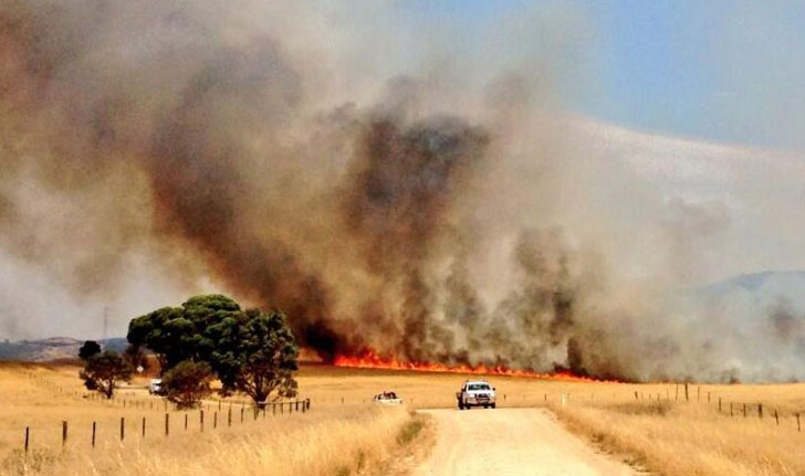
A temporary 44km re-route has taken the Trail around the forest since the devastating January 2014 Bangor Bushfire.

We are currently undertaking re-marking works. Extensive trail signs and infrastructure in the 41km section were damaged or lost. We will publish advice when the trail is re-opened to hikers. In the meantime hikers will need to continue to use the 44km re-route. Re-marking of the original alignment will include removing signs pointing to the temporary re-route.

UPDATE July 2015: The trail through Wirrabara Forest has been restored, with two minor re-routes.

Historic images of Morialta exhibition

2015 will be 100 years since Morialta was declared a National Pleasure Resort on 15 July 1915.

The Friends of Black Hill and Morialta Inc with support from Natural Resources Adelaide and Mount Lofty Ranges are to deliver a number of public events in 2015 to celebrate the centenary of Morialta Conservation Park.

The Friends of the Heysen Trail have sponsored two images. All images are available through an online silent auction, open until November, and any proceeds we receive will go towards our work on the Heysen Trail.

Exhibition Schedule

Coventry Library, Stirling 3 – 13 March 2015
Cleland Wildlife Park 15 – 31 March 2015
The Summit Community Centre, Norton Summit 2 – 30 April 2015
Campbelltown Library 2 – 29 May 2015
Burnside Civic Centre Atrium 3 – 26 June 2015
Gumeracha Library 30 June – 30 July 2015
Tea Tree Gully Library 2 – 28 August 2015
The Long Gallery, St Peters Town Hall Complex 1 – 16 September 2015
The Long Gallery, St Peters Town Hall Complex 22 – 30 September 2015
Cleland Wildlife Park 2 – 31 October 2015
Historic image of Morialta Exhibition 2015

5 Ordinary People hiking the Heysen Trail

5 Ordinary People hiking the Heysen Trail

A family’s 56-day trek

A family of five, including Eli, 12, Emily, 10, and Noah, 9, will skip Term 2 of school in favour of hiking the Heysen Trail.

There’s so much more to life than just maths and English that kids miss out on, if parents don’t invest time in them.

Along with their parents Luke and Erina, they will be a world away from the classroom routine when they undertake a mission to cover 1,151km on foot over 56 days.
Their trek begins at the northern trailhead at Parachilna Gorge, trekking south through the Flinders Ranges and Adelaide Hills to Cape Jervis.

It’s all part of Erina’s plan to give her children an educational experience of a different kind.

“We want to teach our children the life lessons that, when you’re caught up in the nine to five regime, you just don’t have the time to do,” she says. “There’s so much more to life than just maths and English that kids miss out on, if parents don’t invest time in them.”

Follow @5OrdinaryPeople on Facebook.

Heysen Trail article in SA Life magazine

Walking the Talk - SA Life magazine, February 2015

Check out the article in the latest SA Life magazine, Feb 2015. The story looks at walking the entire 1,200km with one of our End-to-End groups.

This year we have seven end-to-end groups walking the trail, all of which are open to new members:

Fire Danger Season Brought Forward 2014/15

Fire Danger Season

The dates for the 2014/2015 Fire Danger Season have been brought forward. The Heysen Trail is closed during these high risk times.

Fire Ban District Start Date End Date
Mount Lofty Ranges 1 December 17 November 2014    30 April 2015
Adelaide Metropolitan    1 December 2014 30 April 2015
Mid North 15 November 1 November 2014 30 April 2015
Flinders 1 November 15 October 2014 15 April 2015

Walkers are reminded to be extra vigilant of fire weather conditions in coming months. Check the Fire Danger Rating before setting out on a hike, monitor changing weather conditions, and always have a back-up plan. Download the CFS smartphone app.

Find which Fire Ban District your planned hike is in on our Interactive Map, by turning on the Fire Ban Districts checkbox layer.

Some short sections of the Heysen Trail remain open year round, principally those sections not on private land. These sections include public roads, Conservation Parks and Reserves (closed on days of Total Fire Ban), Forests (closed on days of Total Fire Ban) and vacant land.

New Heysen Trail Maps for Sale

Heysen Trail new September 2014 map sheets no bgA new series of Heysen Trail maps have been released.

Over the next 12-18 months the Southern and Northern Guidebooks are being gradually replaced with fold-out map sheets.

The first two map sheets are available for purchase now via our online store, for $15 with postage from $1.45.

The maps are double sided and printed on water resistant paper. The maps include elevation profiles with kilometre markers and crossing point names. The new map style allows walkers to gain a “big picture” understanding of where they are on the trail, with a continuous trail line and a constant 3-5km of mapping around the trail.

Remember, you can sign up to receive re-route notifications for your guidebook or map sheet editions. All guidebooks and map sheets published since 2008 are available for notification.

There will be 8 maps in this series:

  • Map 1: Cape Jervis to Kuitpo Forest – available now
  • Map 2: Kuitpo Forest to Tanunda – available now
  • Map 3: Tanunda to Burra – coming soon
  • Map 4: Burra to Spalding – coming soon
  • Map 5: Spalding to Wirrabara Forest – coming soon
  • Map 6: Wirrabara Forest to Dutchmans Stern Conservation Park – coming soon
  • Map 7: Dutchmans Stern Conservation Park to Mernmerna Creek – coming soon
  • Map 8: Mernmerna Creek to Parachilna Gorge – coming soon

Snowfall for End-to-End Minus 1 group

Snow on the summit of Mt Bryan, Saturday 28th June 2014

Snow on the summit of Mt Bryan, Saturday 28th June 2014, End-to-End Minus 1The End-to-End ‘Minus 1’ group experienced snow on the summit of Mt Bryan on Saturday.

pCheck out some of the photos at facebook.com/HeysenTrail (no login required).

At 936 metres Mt Bryan, north of Burra, is the highest peak in the Mt Lofty Ranges and occasionally sees a snow fall. The group is spending five days hiking the trail, starting on Saturday in Hallett, and ending two days south of Burra this Friday. Recent rainfall has flooded paddocks and roads, so their walks between Mt Bryan East and Burra have been postponed to another time. Meanwhile they are continuing their journey southwards.

The photos look more like Tasmania, rather than from where they are in the Mid North of South Australia. Keep warm guys!

Thanks for the photos Robert Alcock and Michael Middleton.