View all news articles below, or select a news category to the right.
Storms damage some sections of the Heysen Trail

The Heysen Trail near Kings Beach – photo by Martin Chapman.
Walkers are advised that some sections of the Heysen Trail have suffered damage during the recent weather events.
As a result
- Tappanappa Campground in Deep Creek Conservation Park (Heysen Trail Southern Guide Book Map 1.3 and Sheet Map 1A) and
- Kaiserstuhl Conservation Park (Southern Guide book Map 4.3 and Sheet Map 2D)
are closed until further notice. Refer to the Parks closures webpage for the latest information.
Walkers need to take care on the trail and particularly near the following locations:
- Kings Beach (near Encounter Bay) – Southern Guide Book Map 1.5 and Sheet Map 1B.
- Giles Conservation Park (near Ashton) – Southern Guide Book Map 3.4 and Sheet Map 2B.
While conditions are generally expected to improve over the next week, it may be sometime before the necessary work can be completed on these sections.
If you find any damage on the trail, please report it to the Friend’s office. To assist our Trail Development volunteers, please advise
- the location and map reference,
- describe the nature of the work required (i.e. marker post has been knocked over) and
- if possible, send a photo.
Adelaide Hills flood damage closes some walking trails.

Flood damage to Montacute Road (picture courtesy of ABC News).
The heavy rains that fell in the Adelaide Hills last week have damaged some popular walking trails and restricted access to several parks.
The lower section of the Waterfall Gully to Mount Lofty trail is closed and may take several months to repair. Alternative access points to the Mount Lofty trail can be found here: Cleland Conservation Park – Waterfall Gully.
While some of the damage has already been repaired, the following parks are also currently affected:
Walkers are advised to check the Park closures listing before setting out to walk in parks in the hills.
Montacute Road at Athelstone and Waterfall Gully Road at Burnside remain closed while repair works continue. Waterfall Gully Road is currently restricted to local traffic only, although it is expected to reopen within a few days.
You can check the current road access at Traffic SA road closures.
Park Closure – The Telowie Gorge Conservation Park and Napperby Block (Mount Remarkable National Park) 23 Sept 2016 to 29 Sept 2016

Telowie Gorge Conservation Park and Napperby Block (Mount Remarkable National Park) will be closed from 6am Friday, 23 September 2016 to 6pm Thursday, 29 September 2016
The purpose of the park closure is to ensure the safety of the public during a pest control program within the parks during the period indicated.
The Heysen Trail passes along the eastern edge of these parks. Hence – Do not divert for the Heysen Trail and attempt to enter these parks at those times.
Especially Relevant – The Go Cart Track Shelter is alongside the HT and within the Telowie Gorge Conservation Park. This shelter may be closed during these times.
The parks are north of Crystal Brook and to the west of the Wirrabara Forest.
For Heysen Trail (HT) users:
Napperby Block is on HT Map Sheet 5B
or on HT Northern Guide Map 2.5
Telowie Gorge CP is on HT Map is Sheet 5B & 6A
or on HT Northern Guide Map 2.6-2.7.
The Go Cart shelter is on HT Map Sheet 6A
or on HT Northern Guide Map 2.7
Please direct any enquiries to Department of Environment, Water and Natural Resources Northern & Yorke. (08) 8841 3400.
Vale Honorary Member Jim Crinion

Jim Crinion
The Friends are saddened to report the death of Honorary Member Jim Crinion. Jim joined the Friends at the initial meeting in June 1986. At that meeting Jim was appointed Chairman of the Steering Committee, tasked with setting up the Friends of the Heysen Trail and Other Walking Trails. Once the Friends were established, Jim continued on as Council member and is well known for leading the original Greening Group which did many years of work, especially with plantings around the Kapunda area. These trees have grown are now enjoyed by todays walkers
An enthusiastic walker in Australia and in many other countries, Jim is also remembered for his popular books of walks – “Adelaide and Country Walks”.
Spring 2016
Issue 141
September 2016
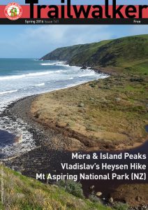 Highlights include:
- Mera & Island Peaks
- Vladislav’s Heysen Hike
- Mt Aspiring National Park (NZ)
Heysen Trail closure in Mt Brown & Dutchmans Stern Conservation Parks from Thursday 1st to Friday 9th September.

The Dutchmans Stern and Mt Brown Conservation Parks will be closed from 6pm on Thursday 1 September 2016 until 6am on Friday 9 September 2016.
The purpose of the closure is to ensure the safety of the public during a pest control program within the parks during the period indicated.
The Heysen Trail passes through these parks, so you are warned not to attempt to enter them at those times.
The Mount Brown Conservation Park is located between Wilmington and Quorn:
- Chapter 3, map 7 of the Northern Guidebook and
- Mapheet 6C, Wirrabara Forest to Dutchmans Stern Conservation Park.
The Dutchmans Stern Conservation Park is just north of Quorn and can be found on the following maps
- Chapter 4, map 2 of the Northern Guidebook and
- Mapheets 6D, Wirrabara Forest to Dutchmans Stern Conservation Park and
7A, Dutchmans Stern Conservation Park to Mernmerna Creek.
Signs will be placed at points where the Heysen Trail enters the parks during the closure.
Please direct any enquiries to Natural Resources, Northern & Yorke.
Walkers be warned – Bees!
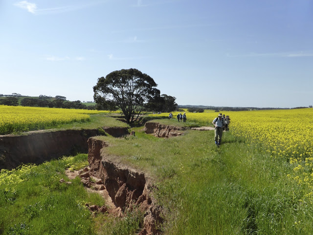
Now is the time you need to take caution when walking near flowering crops. We are now at the highest risk of being attacked by bees.
August to October sees canola crops come into full flower providing picturesque bright yellow fields. The flowers attract bees and the installation of commercial bee hives (clusters of white boxes). Bees don’t take kindly to any interference (intentional or not) and can attack en masse.
What you need to do:
- To reduce the risk, walkers are strongly advised to avoid walking between the bee hives and neighbouring canola crops in flower.
- If your walking trail passes a group of hives, take a wide berth away from them. If possible, stick to made tracks or walk along fencelines. You should avoid walking through crops when off trail.
- If you have experienced reactions to bee stings, you are responsible for carrying appropriate medication. You should also advise your walk leader of any medical condition before you commence your walk.
Stairs and Viewing Platform closed at Waitpinga Beach, July 2016
This is a temporary re-route

Some structural elements of the lower steps no longer reach the sand
The steps and viewing platform at Waitpinga Beach have been closed due to continued sand erosion.
Walkers should find alternative access directly across the sand dunes until the infrastructure has been renewed. DEWNR staff will continue to monitor the sand erosion and structure. We expect alternative arrangements will be put in place, including in the short term a marked route through the sand dunes.
Last August the lower steps were replaced with a dutch sand ladder, but this solution hasn’t worked and has since been removed. The entire structure has now been closed. Prior to approx 2012 there were two separate sets of stair structures, these were removed and replaced with a new single structure, which is the one now affected by erosion.

The viewing platform has been undermined
View all re-routes for the 2014 Southern Guidebook, 6th Edition
Listen to Radio Interview with Ron Kandelaars on 891 ABC Adelaide, 13 July 2016
Friends of the Heysen Trail ambassador, Ron Kandelaars, was interviewed today by Ian Henshke on 891 ABC Adelaide.
He discusses walking South Australia’s 1200 kilometre long Heysen Trail as a great bucket list item, and our organisation’s End-to-End Walking Program. He also interviews Katrina Gillespie who is walking the trail with her two teenage sons and husband together, to set aside their digital devices and walk the Heysen Trail together as a shared experience.
Listen to the interview on SoundCloud.
Trig Campsite to Deep Creek Waterfall, June 2016
View pdf map.

 The Heysen Trail has been re-routed just west of Trig Campsite, through the campsite and down into Deep Creek waterfall. The new trail is a great improvement on the original trail, with a more gentle descent down to the waterfall. The trail crosses Tent Rock Road at the northern entrance to the campsite, with a new car parking area.
Download gpx file.
View all re-routes for the 2014 Southern Guidebook, 6th Edition
Mapsheet 1A: Trig Campsite to Deep Creek Waterfall
View pdf map.
The Trail has been rerouted just west of Trig Campsite, through the campsite and down into Deep Creek waterfall. The Trail crosses Tent Rock Road at the northern entrance to the campsite, with a new car parking area.
Download gpx file.
This re-reoute applies to: Section 2: Cobbler Hill to Tapanappa
View all re-routes for the Mapsheet 1: Cape Jervis to Kuitpo Forest (Sept 2014)
Volunteers Sought for Trail Development
Much of the Heysen Trail infrastructure is now 30 years old.
The Friends Trail Development Committee have plans for many upgrades to both the trail and walker facilities. These plans include –
- Trail remarking and track work – a 3 year project commenced this year.
- Camp site facilities – toilets, water tanks and benches are planned for more sites.
- Hut upgrades to include benches, seats, painting etc.
- New huts are being considered at White Park; Simmons Hill; Cuddlee Creek and a Freemans hut replacement.
- Rebuilding the Waitpinga Beach sand ladder.
You can help
We need help to get these projects moving, both in the field and at our Cobbler Creek shed.
- Waitpinga Beach walkway: We need a team to urgently undertake work on the sand ladder. The existing structure is in a dilapidated condition.
- Cobbler Creek shed, Salisbury East. Urgent work is required to produce items needed for the campsites and huts. We propose to initially open the shed once a month, on a Tuesday from 9 am to 3 pm, for this work.
We would love to hear from anyone with time available and an interest in the trail to HELP us.
Contact us to discuss how you can help.
The trail needs us, please help.
Winter 2016
Issue 140
June 2016
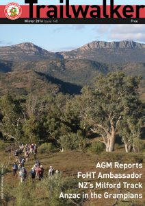 Highlights include:
- AGM Reports
- FoHT Ambassador
- NZ’s Milford Track
- Anzac in the Grampians
Welcome to our new Ambassador: Ron Kandelaars

Ron Kandelaars, ambassador of the Friends of the Heysen Trail
We welcome Ron Kandelaars as our new Friends of the Heysen Trail Ambassador.
At the recent Walk for the Heysen event President Robert welcomed Ron into the role, and presented him with an Ambassador certificate. We all welcome Ron into the Friends family.
Since commencing his media career in the late 1970s, Ron has been involved in many roles, including:
- A permanent two day a week reporter’s role with Channel Seven in Adelaide gathering stories across South Australia
- A regular contributor of “Off The Beaten Track” radio segments on ABC 891 and the corporation’s South Australian regional radio network
- Writer/producer/presenter with Channel Nine’s popular, long running, and multi-award winning travel program ‘Postcards’. In 2011, Ron was awarded South Australian of the Year (Tourism) in the Advantage SA South Australian of the Year Awards; and Outstanding Contribution by an Individual in the South Australian Tourism Awards
- Public relations consultant for a variety of corporate and government clients working on both South Australian and national issues.
Heysen Trail restored to original route through Bundaleer Forest

New toilet constructed at Curnows Hut
The temporary re-route put in place following the January 2013 Bundaleer Forest fire has been removed, and the Heysen Trail is now back on its original alignment. The trail has been re-marked.
In October 2015 Curnows Hut was reopened to walkers. Last week some of our volunteers installed a new toilet at the hut, as the original toilet was destroyed in the fire.
The “new” route returns to that shown on Map 1.4 of the Heysen Trail Northern Guidebook (May 2010 & April 2014 editions) and the Heysen Trail Mapsheet 5 – Spalding to Wirrabara Forest (August 2015).
Re-Route of Heysen Trail near Inman Valley, November 2015
View pdf map.
The Heysen Trail has been re-routed near Inman Valley. The trail now passes through farmland rather than beside the main bitumen road. Although the trail now bypasses the town of Inman Valley, the town and the cafe Inman Valley Country Kitchen are only a short walk from the trail.
Download gpx file.
View all re-routes for the 2014 Southern Guidebook, 6th Edition
Mapsheet 1C: Re-Route of Heysen Trail near Inman Valley
View pdf map.
When walking south-north, the reroute starts at the intersection of Prouse, Hancock and Keens Road following a fence line west behind a telephone tower to enter the Robinson Hill walk-in campsite. Just prior to the tank and platform it turns north west, out of the campsite, down into and through a disused quarry, to cross Hancock Road and enters the Jaggers Forest, over a step-ladder stile. It then follows the forest fence line, initially west, then north, then west again with a final northerly turn to exit the forest onto Roads Lane, over a stile.
Download gpx file.
This re-reoute applies to these 2 sections:
View all re-routes for the Mapsheet 1: Cape Jervis to Kuitpo Forest (Sept 2014)
Re-Route at Mt Remarkable Summit, September 2015
View pdf map.
A new walking trail has been constructed around the western side of the summit to provide views of the north-west of the park and Spencer Gulf. A short walking trail extends from the Heysen Trail to the summit.
A second stage of walking trail will be constructed soon.
As part of these works, the Summit Camp was closed and the hikers’ shelter water tank removed. Melrose and Grays Hut are nearby.
Download gpx file.
View all re-routes for the 2014 Northern Guidebook, 3rd Edition
Walk for the Heysen, inaugural fundraising event, 22nd May 2016 Mt Crawford Forest
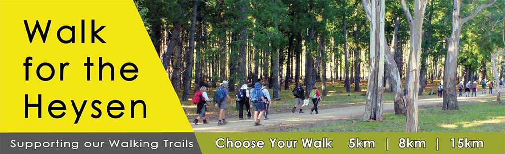
2016 Walk for the Heysen
Sunday 22 May 2016 from 9.30 am
Fromm’s Farm, Mount Road, Mount Crawford
Please join us for the Warren Bonython Heysen Trail Foundation’s inaugural fundraising event.
Proceeds of the Foundation’s fund raising activities are currently used to support greening activities along the Heysen Trail and the restoration of fire damaged sections of the Trail.
There will be three loop walk options of:
- 5 km
- 8 km
- 15 km
All walks depart from and arrive back to the Fromm’s Farm camp-site. Walks are designed to suit all ages and standards of walking fitness.
In keeping with the tradition of the Walk for Warren established by us, the theme for the day will be yellow and a prize consisting of a Heysen Trail merchandise pack to the value of $100 will offered for the best sartorial contribution on the day.
After the walk grab a sausage off the BBQ at the Fromm’s Farm camp-site. Or bring your picnic while enjoying some cool blues with “Deuces Wild”. Fromm’s Farm offers a Large shelter shed and a Picnic area with space to relax.
The cost of registration is $30 for adults, $5 for children and $50 for families.
You may also choose to make a one-off donation to the Foundation through the Foundation’s cause page.
Please note that the Foundation’s application to be registered as an environmental charity is still pending and donations at this point in time are unfortunately not tax deductible.
Download brochure:

Autumn 2016
Issue 139
February 2016
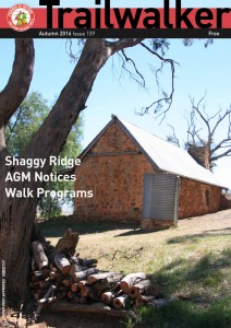 Highlights include:
- Shaggy Ridge
- AGM Notices