Re-route of the Heysen Trail affecting many maps throughout the guidebook, January 2010

The Department for Environment and Water (DEW), publisher of the Heysen Trail guidebooks, have issued printing corrections to this edition.
Download pdf of the corrections.
In addition to this list, there is an error on page 32, the phone number for Heysen’s Rest Bed & Breakfast appears incorrectly, the correct phone number is (08) 8558 6397.

View all re-routes for the 2010 Southern Guidebook, 3rd Edition

Re-route of the Heysen Trail affecting Map 1.2, January 2012

View pdf map showing re-route

The Heysen Trail east of the Deep Creek Waterfall has been re-routed to avoid an eroded, steep section of the trail. Hiking east, the 2.1km re-route begins immediately south of the waterfall. Where the trail used to turn east and head up a steep hill, the trail now continues along the creek, contouring around the hill to rejoin the main trail approximately 1km to the east.

View all re-routes for the 2004 Southern Guidebook, 1st Edition

Re-route of the Heysen Trail affecting Map 1.2, January 2012

View pdf map showing re-route

The Heysen Trail east of the Deep Creek Waterfall has been re-routed to avoid an eroded, steep section of the trail. Hiking east, the 2.1km re-route begins immediately south of the waterfall. Where the trail used to turn east and head up a steep hill, the trail now continues along the creek, contouring around the hill to rejoin the main trail approximately 1km to the east.

View all re-routes for the 2007 Southern Guidebook, 2nd Edition

Re-route of the Heysen Trail affecting Map 1.2, January 2012

View pdf map showing re-route

The Heysen Trail east of the Deep Creek Waterfall has been re-routed to avoid an eroded, steep section of the trail. Hiking east, the 2.1km re-route begins immediately south of the waterfall. Where the trail used to turn east and head up a steep hill, the trail now continues along the creek, contouring around the hill to rejoin the main trail approximately 1km to the east.

View all re-routes for the 2010 Southern Guidebook, 3rd Edition

Trig Campsite to Deep Creek Waterfall, June 2016

View pdf map showing re-route

Re-Route of Heysen Trail near Trig Campsite to Deep Creek Waterfall

Re-Route of Heysen Trail near Trig Campsite to Deep Creek Waterfall (2)The Heysen Trail has been re-routed just west of Trig Campsite, through the campsite and down into Deep Creek waterfall. The new trail is a great improvement on the original trail, with a more gentle descent down to the waterfall. The trail crosses Tent Rock Road at the northern entrance to the campsite, with a new car parking area.

Download gpx file for loading onto your GPS unit.

View all re-routes for the 2014 Southern Guidebook, 6th Edition

Re-route of the Heysen Trail affecting Map 1.3, January 2008

View pdf map showing re-route

The Heysen Trail has been re-routed in the descent to Boat Harbor Beach. The $90,000 upgrade aims to make the badly eroded section of the trail more environmentally sustainable and provide a more spectacular trek for walkers. The trail previously hugged the coastline and led its walkers up steep hills, causing significant erosion. The track was realigned to follow the land contours, rather than going up and down hills.

View all re-routes for the 2004 Southern Guidebook, 1st Edition

Re-route of the Heysen Trail affecting Map 1.3, January 2008

View pdf map showing re-route

The Heysen Trail has been re-routed in the descent to Boat Harbor Beach. The $90,000 upgrade aims to make the badly eroded section of the trail more environmentally sustainable and provide a more spectacular trek for walkers. The trail previously hugged the coastline and led its walkers up steep hills, causing significant erosion. The track was realigned to follow the land contours, rather than going up and down hills.

View all re-routes for the 2007 Southern Guidebook, 2nd Edition

Stairs and Viewing Platform closed at Waitpinga Beach, July 2016

This is a temporary re-route

Steps at Waitpinga Beach following sand erosion

Some structural elements of the lower steps no longer reach the sand

The steps and viewing platform at Waitpinga Beach have been closed due to continued sand erosion.

Walkers should find alternative access directly across the sand dunes until the infrastructure has been renewed. DEWNR staff will continue to monitor the sand erosion and structure. We expect alternative arrangements will be put in place, including in the short term a marked route through the sand dunes.

Last August the lower steps were replaced with a dutch sand ladder, but this solution hasn’t worked and has since been removed. The entire structure has now been closed. Prior to approx 2012 there were two separate sets of stair structures, these were removed and replaced with a new single structure, which is the one now affected by erosion.

The viewing platform has been undermined

The viewing platform has been undermined

View all re-routes for the 2014 Southern Guidebook, 6th Edition

Re-Route of Heysen Trail near Inman Valley, November 2015

View pdf map showing re-route

The Heysen Trail has been re-routed near Inman Valley. The trail now passes through farmland rather than beside the main bitumen road. Although the trail now bypasses the town of Inman Valley, the town and the cafe Inman Valley Country Kitchen are only a short walk from the trail.

Download gpx file for loading onto your GPS unit.

View all re-routes for the 2014 Southern Guidebook, 6th Edition

Re-route of the Heysen Trail affecting Map 2.9, May 2012

This temporary re-route has been restored to the original trail alignment

View pdf map showing re-route

A temporary re-route is in place in Kuitpo Forest, near Christmas Hill, south of the Kuitpo Forest Information Centre. Due to intensive harvesting operations, the trail has been re-routed via Brookman Road (the main bitumen road). Signs are in place at either end of the re-route. The re-route is anticipated to be in place for six weeks, however even after that time you should obey signs on the trail. We will remove this re-route note from our website when we are advised by Forestry SA that the original trail is safe to continue on through the forest.

View all re-routes for the 2004 Southern Guidebook, 1st Edition

Re-route of the Heysen Trail affecting Map 2.9, June 2012

This is a temporary re-route

View pdf map showing re-route

This is an amendment to the temporary re-route which was installed in early May 2012, through in Kuitpo Forest, near Christmas Hill, south of the Kuitpo Forest Information Centre. Due to intensive harvesting operations, the trail has been re-routed via Brookman Road (the main bitumen road). Signs are in place at either end of the re-route. You should obey re-route signs on the trail. We will remove this re-route note from our website when we are advised by Forestry SA that the original trail is safe to continue on through the forest.

View all re-routes for the 2004 Southern Guidebook, 1st Edition

Re-route of the Heysen Trail affecting Map 2.9, May 2012

This temporary re-route has been restored to the original trail alignment

View pdf map showing re-route

A temporary re-route is in place in Kuitpo Forest, near Christmas Hill, south of the Kuitpo Forest Information Centre. Due to intensive harvesting operations, the trail has been re-routed via Brookman Road (the main bitumen road). Signs are in place at either end of the re-route. The re-route is anticipated to be in place for six weeks, however even after that time you should obey signs on the trail. We will remove this re-route note from our website when we are advised by Forestry SA that the original trail is safe to continue on through the forest.

View all re-routes for the 2007 Southern Guidebook, 2nd Edition

Re-route of the Heysen Trail affecting Map 2.9, June 2012

This is a temporary re-route

View pdf map showing re-route

This is an amendment to the temporary re-route which was installed in early May 2012, through in Kuitpo Forest, near Christmas Hill, south of the Kuitpo Forest Information Centre. Due to intensive harvesting operations, the trail has been re-routed via Brookman Road (the main bitumen road). Signs are in place at either end of the re-route. You should obey re-route signs on the trail. We will remove this re-route note from our website when we are advised by Forestry SA that the original trail is safe to continue on through the forest.

View all re-routes for the 2007 Southern Guidebook, 2nd Edition

Re-route of the Heysen Trail affecting Map 2.9, May 2012

This temporary re-route has been restored to the original trail alignment

View pdf map showing re-route

A temporary re-route is in place in Kuitpo Forest, near Christmas Hill, south of the Kuitpo Forest Information Centre. Due to intensive harvesting operations, the trail has been re-routed via Brookman Road (the main bitumen road). Signs are in place at either end of the re-route. The re-route is anticipated to be in place for six weeks, however even after that time you should obey signs on the trail. We will remove this re-route note from our website when we are advised by Forestry SA that the original trail is safe to continue on through the forest.

View all re-routes for the 2010 Southern Guidebook, 3rd Edition

Re-route of the Heysen Trail affecting Map 2.9, June 2012

This is a temporary re-route

View pdf map showing re-route

This is an amendment to the temporary re-route which was installed in early May 2012, through in Kuitpo Forest, near Christmas Hill, south of the Kuitpo Forest Information Centre. Due to intensive harvesting operations, the trail has been re-routed via Brookman Road (the main bitumen road). Signs are in place at either end of the re-route. You should obey re-route signs on the trail. We will remove this re-route note from our website when we are advised by Forestry SA that the original trail is safe to continue on through the forest.

View all re-routes for the 2010 Southern Guidebook, 3rd Edition

Kuitpo Forest, adjoining Mt Bold, Map 3.1, April 2014 (from 2011)

View pdf map showing re-route.

This re-route notification is to publish a re-route that was undertaken by Forestry SA sometime around 2011.

The trail has been routed along the forest rather than through it.

In September 2014 this re-route was returned to the original trail route through the forest as originally published in the guidebook.

View all re-routes for the 2010 Southern Guidebook, 3rd Edition

Re-route of the Heysen Trail in Kuitpo Forest, map 3.1, adjoining Mt Bold, April 2014 (from 2011)

View pdf map showing re-route.

This re-route notification is to publish a re-route that was undertaken by Forestry SA sometime around 2011.

The trail has been routed along the forest rather than through it.

In September 2014 this re-route was returned to the original trail route through the forest as originally published in the guidebook.

High Water Crossing Alternate Route entering Morialta Conservation Park, February 2021

View pdf map showing re-route

When entering Morialta Conservation Park from Norton Summit:

  1. when the creek water level us low, there is a 140m long low water crossing, and
  2. when the creek water levels are high there is a 1.6km long high water crossing alternate route along Colonial Drive and Colonial Track

Download gpx file for loading onto your GPS unit.

View all re-routes for the 2014 Southern Guidebook, 6th Edition

Re-route of the Heysen Trail affecting Map 3.7, August 2013

This is a temporary re-route

View pdf map showing re-route

Foresty SA is conducting logging in the area of Bennett’s forest (Mt Crawford Forest), also known as Simmonds Hill adjacent to Little Parra Road. Logging activities are expected to be ongoing for at least a few months in this area. The short re-route has been marked by Forestry SA.

Reroute of the Heysen Trail near Chain of Ponds where it crosses North East Road, Early 2021

View pdf map showing re-route

This re-route was marked in early 2021 to allow for a roadwork upgrade of the junction of North East Road and South Para Road.
It was expected to be a temporary change until the roadworks were completed in June 2021.

The route shown in purple is the Heysen Trail in Chain of Ponds crossing North East Road.

UPDATE December 2021. Due to land access issues related to SA Water property, the trail has not returned to the original route. Further options are being investigated.

CAUTION: The re-routed trail now crosses North East Rd about 50 metres from the crest of a hill which makes for a dangerous road crossing. This is dangerous as the speed limit on the North East Rd is 100 km/h.
Please be extra cautious when crossing the road.

Download gpx file for loading onto your GPS unit.

View all re-routes for the 2014 Southern Guidebook, 6th Edition

Reroutes in Mt Crawford forest, August 2020

View pdf map showing re-route

The Heysen Trail has been re-routed in Mt Crawford forest in three places:

  1. The main trail (which is the route along the southern then eastern side) has been re-routed off of Chalks Road
  2. The alternative trail (which is the route along the north-western side) has been re-routed via Warren Reservoir to Centennial Drive
  3. When the South Para River water level is high, avoid the main trail crossing (marked #3, upstream to the east) and walk 900m downstream to cross the river on the Mount Rd bridge (marked #4, downstream to the west)

Download gpx file for loading onto your GPS unit.

View all re-routes for the 2014 Southern Guidebook, 6th Edition

Re-route of the Heysen Trail affecting Maps 4.1 and 3.9, July 2012

View pdf map showing re-route

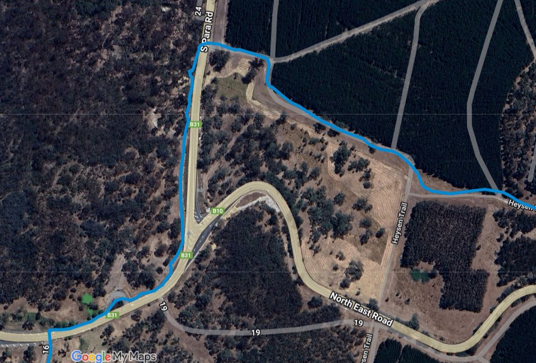
Over time there have been various re-routes affecting maps 3.9 and 4.1, there is now a fifth re-route in the area. Please use this updated map.

1) The alternative route via Wirra Wirra Road, Blockers Road and Towers Road is no longer available. This re-route is no longer marked on the attached map. Please use the main trail route over Wirra Wirra Peaks.

2) Re-route near landing ground.

3) The western option has been closed, this is marked with no entry signs on the attached map.

4) A temporary closure of the trail along Centennial Drive and over Mt Crawford. The closure is due to logging operations and includes the Centennial Drive campground.

5) UPDATE: There is a minor re-route in place near the Old School House. Heading south to north on the trail, the trail exits from the bitumen Springton Road a 300m prior to the original route, before heading to the Old School House.

View all re-routes for the 2004 Southern Guidebook, 1st Edition

Re-route of the Heysen Trail affecting Maps 4.1 and 3.9, July 2012

View pdf map showing re-route

Over time there have been various re-routes affecting maps 3.9 and 4.1, there is now a fourth re-route in the area. Please use this updated map.

1) The alternative route via Wirra Wirra Road, Blockers Road and Towers Road is no longer available. Please use the main trail route over Wirra Wirra Peaks.

2) Re-route near landing ground.

3) A temporary closure of the trail along Centennial Drive and over Mt Crawford. The closure is due to logging operations and includes the Centennial Drive campground.

4) UPDATE: There is a minor re-route in place near the Old School House. Heading south to north on the trail, the trail exits from the bitumen Springton Road a 300m prior to the original route, before heading to the Old School House.

View all re-routes for the 2007 Southern Guidebook, 2nd Edition

Re-Route returning the trail to Tower Hill, avoid closed Freemans Hut, and Re-Route near Mt Crawford Summit, April 2016 (updated May 2018, updated November 2021)

View pdf map showing re-route

  1. Freemans Hut on the Heysen Trail near Mt Crawford has been closed due to a land sale, and the trail re-routed to continue north along the Wirra Wirra Peaks ridge line.

    [update May 2018] The trail has been re-routed away from Tower Road, to the east to follow Wirra Wirra Road to the north to meet Corryton Road.

    [update November 2021] Following successful negotiations with landholders in the area, the Heysen Trail has returned to the route initially adopted in 2016 following the closure of the trail to Freemans Hut.

    After the descent from the Wirra Wirra peaks, the trail again follows Tower Road in a northerly direction for a kilometre. It then crosses a fence into private property. The trail follows the fenceline for another kilometre before reaching the summit of Tower Hill, which affords spectacular views in all directions.

    The trail continues along the fenceline until reaching the Ross Fire Track where it turns in an easterly direction along an unmade road reserve. This section of the trail continues until it leaves the road reserve at the junction of Wirra Wirra, Trial Hill and Corryton Park Roads.

  2. [update May 2018] The Heysen Trail climbs over the summit of Mt Crawford. There is now a river crossing on stepping stones near the base of the summit. When river water levels are high, use the route west over the road bridge.

Download gpx file for loading onto your GPS unit.

View all re-routes for the 2014 Southern Guidebook, 6th Edition

Re-route of the Heysen Trail affecting Maps 4.2, 4.1 and 3.9, July 2012

View pdf map showing re-route

Over time there have been various re-routes affecting maps 3.9, 4.1 and 4.2, there is a fourth re-route in the area. Please use this updated map.

1) The alternative route via Wirra Wirra Road, Blockers Road and Towers Road is no longer available. Please use the main trail route over Wirra Wirra Peaks.

2) The alternative route does NOT extend north along Blockers Road to the Ross Fire Track. The alternative route rejoins the main trail as shown at the intersection of Tower Road and the spot marked ‘F’.

3) A temporary closure of the trail along Centennial Drive and over Mt Crawford. The closure is due to logging operations and includes the Centennial Drive campground.

4) UPDATE: There is a minor re-route in place near the Old School House. Heading south to north on the trail, the trail exits from the bitumen Springton Road a 300m prior to the original route, before heading to the Old School House.

View all re-routes for the 2010 Southern Guidebook, 3rd Edition

Re-route of the Heysen Trail affecting Map 4.5, July 2009

From July 2009 to early 2010 there will be major roadworks associated with the upgrading of the Sturt Highway near Greenock. A new bridge will be constructed along Roennfeldt Road over Greenock Creek. An additional carriageway will be built alongside the existing Sturt Highway which means Roennfeldt Road will be moved south of its current position. Another bridge for the highway will be constructed over Seppeltsfield Road.

Walkers are advised to use caution when walking along the road when machinery is operating. Take care when passing through the area and be sure plant and machinery operators or other workers are aware of your presence. Once the roadworks are complete the Heysen Trail will be rerouted along the Greenock Creek under the new Sturt Highway bridge, then along the northern side of the highway into Greenock.

View all re-routes for the 2004 Southern Guidebook, 1st Edition

Re-route of the Heysen Trail affecting Map 4.5, July 2009

From July 2009 to early 2010 there will be major roadworks associated with the upgrading of the Sturt Highway near Greenock. A new bridge will be constructed along Roennfeldt Road over Greenock Creek. An additional carriageway will be built alongside the existing Sturt Highway which means Roennfeldt Road will be moved south of its current position. Another bridge for the highway will be constructed over Seppeltsfield Road.

Walkers are advised to use caution when walking along the road when machinery is operating. Take care when passing through the area and be sure plant and machinery operators or other workers are aware of your presence. Once the roadworks are complete the Heysen Trail will be rerouted along the Greenock Creek under the new Sturt Highway bridge, then along the northern side of the highway into Greenock.

View all re-routes for the 2007 Southern Guidebook, 2nd Edition

Re-route to Kapunda Square, June 2019

View pdf map showing re-route

The Heysen Trail has been re-routed to take the trail into central Kapunda, to the newly constructed Kapunda Town Square (corner Main St and Crase St), and to be closer to bakeries, coffee shops, the camping ground and caravan park.

In July 2020 the route has been tweaked: heading north, the main trail continues along Cameron St, Branson Crescent and Crase St. An short alternative option is from Cameron St, along Mine St, then Whittaker St turning on to Crase St.

Download gpx file for loading onto your GPS unit.

View all re-routes for the 2014 Southern Guidebook, 6th Edition

Re-route of the Heysen Trail affecting Map 5.11, September 2012

A new camp site is being constructed just north of Worlds End/Burra Gorge. The new hike-in camp site will be completed in October 2012, and we anticipate water will be available for the 2013 hiking season.

The camp site features a shelter with water tank and bench, and a square bench/table.

More info, including photos, will be posted on this page later: http://www.heysentrail.asn.au/forums/viewtopic.php?t=685&accom_id=685&name=Worlds End Hike-in Camp Site

Distances:
Huppatz Hut to Worlds End Hike-in Camp Site – 21.3km
Worlds End Hike-in Camp Site to Burra – 23.0km

View all re-routes for the 2004 Southern Guidebook, 1st Edition

Re-route of the Heysen Trail affecting Map 5.11, September 2012

View pdf map showing re-route

A new camp site is being constructed just north of Worlds End/Burra Gorge. The new hike-in camp site will be completed in October 2012, and we anticipate water will be available for the 2013 hiking season.

The camp site features a shelter with water tank and bench, and a square bench/table.

More info, including photos, will be posted on this page later: http://www.heysentrail.asn.au/forums/viewtopic.php?t=685&accom_id=685&name=Worlds End Hike-in Camp Site

Distances:
Huppatz Hut to Worlds End Hike-in Camp Site – 21.3km
Worlds End Hike-in Camp Site to Burra – 23.0km

View all re-routes for the 2007 Southern Guidebook, 2nd Edition

Re-route of the Heysen Trail affecting Map 5.11, September 2012

View pdf map showing re-route

A new camp site is being constructed just north of Worlds End/Burra Gorge. The new hike-in camp site will be completed in October 2012, and we anticipate water will be available for the 2013 hiking season.

The camp site features a shelter with water tank and bench, and a square bench/table.

More info, including photos, will be posted on this page later: http://www.heysentrail.asn.au/forums/viewtopic.php?t=685&accom_id=685&name=Worlds End Hike-in Camp Site

Distances:
Huppatz Hut to Worlds End Hike-in Camp Site – 21.3km
Worlds End Hike-in Camp Site to Burra – 23.0km

View all re-routes for the 2010 Southern Guidebook, 3rd Edition

Re-route of the Heysen Trail affecting Map 5.11, September 2012

View pdf map showing re-route

A new camp site is being constructed just north of Worlds End/Burra Gorge. The new hike-in camp site will be completed in October 2012, and we anticipate water will be available for the 2013 hiking season.

The camp site features a shelter with water tank and bench, and a square bench/table.

More info, including photos, will be posted on this page later: http://www.heysentrail.asn.au/forums/viewtopic.php?t=685&accom_id=685&name=Worlds End Hike-in Camp Site

Distances:
Huppatz Hut to Worlds End Hike-in Camp Site – 21.3km
Worlds End Hike-in Camp Site to Burra – 23.0km

Re-route of the Heysen Trail affecting Map 5.6, September 2012

View pdf map showing re-route

A new camp site is being constructed on Smith Hill. The new camp site will be completed in October 2012, and we anticipate water will be available for the 2013 hiking season.

The camp site features a shelter with water tank and bench, and a square bench/table.

More info, including photos, will be posted on this page later: http://www.heysentrail.asn.au/forums/viewtopic.php?t=683&accom_id=683&name=Smith Hill Camp Site

Distances:
Maschalls Hut to Marabel – 8.6km
Marabel to Smith Hill Camp Site – 17.3km

View all re-routes for the 2004 Southern Guidebook, 1st Edition

Re-route of the Heysen Trail affecting Map 5.6, September 2012

View pdf map showing re-route

A new camp site is being constructed on Smith Hill. The new camp site will be completed in October 2012, and we anticipate water will be available for the 2013 hiking season.

The camp site features a shelter with water tank and bench, and a square bench/table.

More info, including photos, will be posted on this page later: http://www.heysentrail.asn.au/forums/viewtopic.php?t=683&accom_id=683&name=Smith Hill Camp Site

Distances:
Maschalls Hut to Marabel – 8.6km
Marabel to Smith Hill Camp Site – 17.3km

View all re-routes for the 2007 Southern Guidebook, 2nd Edition

Re-route of the Heysen Trail affecting Map 5.6, September 2012

View pdf map showing re-route

A new camp site is being constructed on Smith Hill. The new camp site will be completed in October 2012, and we anticipate water will be available for the 2013 hiking season.

The camp site features a shelter with water tank and bench, and a square bench/table.

More info, including photos, will be posted on this page later: http://www.heysentrail.asn.au/forums/viewtopic.php?t=683&accom_id=683&name=Smith Hill Camp Site

Distances:
Maschalls Hut to Marabel – 8.6km
Marabel to Smith Hill Camp Site – 17.3km

View all re-routes for the 2010 Southern Guidebook, 3rd Edition

Re-route of the Heysen Trail affecting Map 5.6, September 2012

View pdf map showing re-route

A new camp site is being constructed on Smith Hill. The new camp site will be completed in October 2012, and we anticipate water will be available for the 2013 hiking season.

The camp site features a shelter with water tank and bench, and a square bench/table.

More info, including photos, will be posted on this page later: http://www.heysentrail.asn.au/forums/viewtopic.php?t=683&accom_id=683&name=Smith Hill Camp Site

Distances:
Maschalls Hut to Marabel – 8.6km
Marabel to Smith Hill Camp Site – 17.3km

Re-route of the Heysen Trail affecting Map 5.7, September 2012

View pdf map showing re-route

A new camp site is being constructed at Webb Gap. The new camp site will be completed in October 2012, and we anticipate water will be available for the 2013 hiking season.

The camp site features a shelter with water tank and bench, and a square bench/table.

More info, including photos, will be posted on this page later: http://www.heysentrail.asn.au/forums/viewtopic.php?t=684&accom_id=684&name=Webb Gap Camp Site

Distances:
Smith Hill Camp Site to Webb Gap Camp Site – 13.3km
Webb Gap Camp Site to Huppatz Hut – 16.2km

View all re-routes for the 2004 Southern Guidebook, 1st Edition

Re-route of the Heysen Trail affecting Map 5.7, September 2012

View pdf map showing re-route

A new camp site is being constructed at Webb Gap. The new camp site will be completed in October 2012, and we anticipate water will be available for the 2013 hiking season.

The camp site features a shelter with water tank and bench, and a square bench/table.

More info, including photos, will be posted on this page later: http://www.heysentrail.asn.au/forums/viewtopic.php?t=684&accom_id=684&name=Webb Gap Camp Site

Distances:
Smith Hill Camp Site to Webb Gap Camp Site – 13.3km
Webb Gap Camp Site to Huppatz Hut – 16.2km

View all re-routes for the 2007 Southern Guidebook, 2nd Edition

Re-route of the Heysen Trail affecting Map 5.7, September 2012

View pdf map showing re-route

A new camp site is being constructed at Webb Gap. The new camp site will be completed in October 2012, and we anticipate water will be available for the 2013 hiking season.

The camp site features a shelter with water tank and bench, and a square bench/table.

More info, including photos, will be posted on this page later: http://www.heysentrail.asn.au/forums/viewtopic.php?t=684&accom_id=684&name=Webb Gap Camp Site

Distances:
Smith Hill Camp Site to Webb Gap Camp Site – 13.3km
Webb Gap Camp Site to Huppatz Hut – 16.2km

View all re-routes for the 2010 Southern Guidebook, 3rd Edition

Re-route of the Heysen Trail affecting Map 5.7, September 2012

View pdf map showing re-route

A new camp site is being constructed at Webb Gap. The new camp site will be completed in October 2012, and we anticipate water will be available for the 2013 hiking season.

The camp site features a shelter with water tank and bench, and a square bench/table.

More info, including photos, will be posted on this page later: http://www.heysentrail.asn.au/forums/viewtopic.php?t=684&accom_id=684&name=Webb Gap Camp Site

Distances:
Smith Hill Camp Site to Webb Gap Camp Site – 13.3km
Webb Gap Camp Site to Huppatz Hut – 16.2km

Re-route of the Heysen Trail affecting Maps 5.8 and 5.9, July 2012

View pdf map showing re-route

The 2km re-route is shorter than the former trail section that followed dirt roads. The re-route is on private land and follows a rough but clearly defined vehicular track high on the western slope of the Tothill Ranges. It provides magnificent views over Apoinga Lagoon, the Tothill Ranges and the Waterloo Wind Farm. Travelling north, it begins at the intersection of the Tothill Belt Road and Black Springs Road and rejoins the Heysen Trail where the former trail turned north at the junction with a minor north-south stream. The re-route is marked.

View all re-routes for the 2004 Southern Guidebook, 1st Edition

Re-route of the Heysen Trail affecting Maps 5.8 and 5.9, July 2012

View pdf map showing re-route

The 2km re-route is shorter than the former trail section that followed dirt roads. The re-route is on private land and follows a rough but clearly defined vehicular track high on the western slope of the Tothill Ranges. It provides magnificent views over Apoinga Lagoon, the Tothill Ranges and the Waterloo Wind Farm. Travelling north, it begins at the intersection of the Tothill Belt Road and Black Springs Road and rejoins the Heysen Trail where the former trail turned north at the junction with a minor north-south stream. The re-route is marked.

View all re-routes for the 2007 Southern Guidebook, 2nd Edition

Re-route of the Heysen Trail affecting Maps 5.8 and 5.9, July 2012

View pdf map showing re-route

The 2km re-route is shorter than the former trail section that followed dirt roads. The re-route is on private land and follows a rough but clearly defined vehicular track high on the western slope of the Tothill Ranges. It provides magnificent views over Apoinga Lagoon, the Tothill Ranges and the Waterloo Wind Farm. Travelling north, it begins at the intersection of the Tothill Belt Road and Black Springs Road and rejoins the Heysen Trail where the former trail turned north at the junction with a minor north-south stream. The re-route is marked.

View all re-routes for the 2010 Southern Guidebook, 3rd Edition

Re-route of the Heysen Trail affecting Map 6.12, May 2011

View pdf map showing re-route

The trail has been re-routed through the town of Spalding, leaving the trail at the channel between Railway Dam Road and Borve Hill Road, and rejoining the original trail alignment near Freshwater Creek Weir. Due to SA Water OHS demands there is a minor alteration around Freshwater Creek Weir – the trail no longer passes over the weir wall. The channel has recently been reinstated after many years out of service.

View all re-routes for the 2004 Southern Guidebook, 1st Edition

Re-route of the Heysen Trail affecting Map 6.12, May 2011

View pdf map showing re-route

The trail has been re-routed through the town of Spalding, leaving the trail at the channel between Railway Dam Road and Borve Hill Road, and rejoining the original trail alignment near Freshwater Creek Weir. Due to SA Water OHS demands there is a minor alteration around Freshwater Creek Weir – the trail no longer passes over the weir wall. The channel has recently been reinstated after many years out of service.

View all re-routes for the 2007 Southern Guidebook, 2nd Edition

Re-route of the Heysen Trail affecting Map 6.12, April 2011

The trail markers have now been placed, the trail now follows the route as published in the guidebook.

Due to SA Water OHS demands there is a minor alteration around Freshwater Creek Weir – the trail no longer passes over the weir wall. The channel has recently been reinstated after many years out of service.

From May 2010 until April 2011. With the publication of this edition the trail is shown as being re-routed through the town of Spalding. This re-route has not yet been marked, it is expected to be done prior to the commencement of the 2011 walking season in April, 2011. Until such time, the trail is marked from near the rubbish dump, south of Borve Road, as continuing along the drainage channel to Freshwater Weir.

View all re-routes for the 2010 Southern Guidebook, 3rd Edition

Re-route of the Heysen Trail affecting Map 6.9, October 2012

View pdf map showing re-route

A new camp site has been constructed at a trig between Hallett and Spalding. We anticipate water will be available for the 2013 hiking season.

This campsite replaces the former water source at Willalo Hall. It is 22.5km from Hallett and 26km from Spalding.

The camp site features a shelter with water tank and bench. It is in a windy and exposed location, so may not be suitable for all tents.

More info in the accommodation forum at http://www.heysentrail.asn.au/forums/viewtopic.php?t=697&accom_id=697&name=Whistling%20Trig%20Tank

View all re-routes for the 2004 Southern Guidebook, 1st Edition

Re-route of the Heysen Trail affecting Map 6.9, October 2012

View pdf map showing re-route

A new camp site has been constructed at a trig between Hallett and Spalding. We anticipate water will be available for the 2013 hiking season.

This campsite replaces the former water source at Willalo Hall. It is 22.5km from Hallett and 26km from Spalding.

The camp site features a shelter with water tank and bench. It is in a windy and exposed location, so may not be suitable for all tents.

More info in the accommodation forum at http://www.heysentrail.asn.au/forums/viewtopic.php?t=697&accom_id=697&name=Whistling%20Trig%20Tank

View all re-routes for the 2007 Southern Guidebook, 2nd Edition

Re-route of the Heysen Trail affecting Map 6.9, October 2012

View pdf map showing re-route

A new camp site has been constructed at a trig between Hallett and Spalding. We anticipate water will be available for the 2013 hiking season.

This campsite replaces the former water source at Willalo Hall. It is 22.5km from Hallett and 26km from Spalding.

The camp site features a shelter with water tank and bench. It is in a windy and exposed location, so may not be suitable for all tents.

More info in the accommodation forum at http://www.heysentrail.asn.au/forums/viewtopic.php?t=697&accom_id=697&name=Whistling%20Trig%20Tank

View all re-routes for the 2010 Southern Guidebook, 3rd Edition

Re-route of the Heysen Trail affecting Map 6.9, September 2012

View pdf map showing re-route

A new camp site has been constructed at a trig between Hallett and Spalding. We anticipate water will be available for the 2013 hiking season.

This campsite replaces the former water source at Willalo Hall. It is 22.5km from Hallett and 26km from Spalding.

The camp site features a shelter with water tank and bench. It is in a windy and exposed location, so may not be suitable for all tents.

More info in the accommodation forum at http://www.heysentrail.asn.au/forums/viewtopic.php?t=697&accom_id=697&name=Whistling%20Trig%20Tank