Big bold idea for Heysen Trail Northern Trailhead

The Existing Northern Trailhead

Exciting news about a bold new proposal to enhance the Heysen Trail northern Trailhead!!

Do you remember the feeling as you started or completed the Heysen at the Parachilna Gorge trailhead?   Many have described the climb over that Trailhead stile as “underwhelming” – for such a grand occasion.

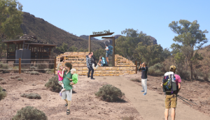
The new design – northbound view

In 2022, The Friends Council supported a proposal to investigate ways to give the 30+ year old Trailhead a makeover.

We envisaged a gateway offering a greater sense of significance and a place of arrival/launching for the 1200km Heysen achievement.

The Friends engaged Landscape Architects to work with The Friends and consult with local landholders, community organisations, and local Adnyamathanha representatives, about a suitable concept – a concept that The Friends Council has now endorsed.

After preliminary discussion with the Department for Environment & Water (DEW), The Friends are optimistic that the go ahead for the concept will be forthcoming.

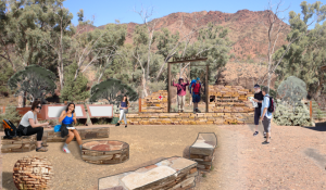
The southbound view

The design concept, shown to the right, looks inspiring and will incorporate planting / landscaping.

A more detailed design package is available by clicking on this link: Heysen Trail Northern Trailhead.

We hope you’ll agree that it’s a worthwhile and very exciting project!

FOHT Website Review – Update

Members would be aware that The Friends Promotion: Membership & Marketing Standing Committee (PMM) has been canvassing views about the need to improve and modernize our website.  Consultation across the Friends Committees and a member survey have informed the assessment that it is time to generate a visually appealing website with simpler navigation.

PMM has now completed a tender process by engaging an experienced design and software team to provide The Friends with future design options.  PMM is aiming for completion in 2024.

Heysen Trail GPX files update for GPS: latest edition includes 9 reroutes

This is a summary of the latest permanent reroutes of the Heysen Trail that have been undertaken by the Trail Development Committee in consultation with the Department of Environment & Water (DEW).

The reroutes have been added to the downloadable GPX file (version 4.4 released 7/8/2023) and the Interactive Map as displayed on Friends of the Heysen Trail website.

You can find instructions for downloading the updated file onto your GPS unit on the Maps & GPS page.

The following re-routes and updates have been added:

  1. Mapsheet 1A – Reroute around Tapanappa Campsite for the Wild South Coast Way
  2. Mapsheet 1A-1B – The Wild South Coast Way spur trail from Kings Beach to Victor Harbor
  3. Mapsheet 1C – Reroute at Robinson Hill/Jaggers Block, September 2022
  4. Mapsheet 1D – Reroute at Kyeema – exit off Woodgate Hill Rd, December 2022
  5. Mapsheet 1D and 2A – Reroute at Chookarloo Campground, Kuitpo Forest, January 2023
  6. Mapsheet 1D and 2A – Alternate Route at Knott Hill Plantation (Kuitpo Forest), April 2023
  7. Mapsheet 2D – Reroute at Old School House, Mt Crawford Forest, July 2023
  8. Mapsheet 4B – Realignment of the trail east of Mt Bryan, September 2022
  9. Mapsheet 8C – Yuluna realignment, Ikara Flinders Ranges National Park, April 2023

Please note the the revised gpx file does not include temporary reroutes such as :

  • Those frequently established around Forestry SA logging operations in the Kuitpo and Mt Crawford Forest reserves (Mapsheets 1D, 2A & 2D)
  • The Maryvale reroute, south of Hamilton (Mapsheet 3B)
  • The Goyder Windfarm reroute, east of Huppatz Hut (Mapsheet 3D

Walkers are advised to check the Heysen Trail Reroutes page before setting out on any walk to make sure you are aware of any recent trail changes.

The reroutes have also had a very minor impact on the Heysen Trail Distances.

Heysen Trail closure north of Cudlee Creek, 19th-21st May 2023

Forestry SA has announced that there will be a closure of  the Heysen Trail in the Bennett’s Planation, north of Cudlee Creek, from Friday May 19th (all day) till Sunday May 21st (all day).

This is to enable Re-Enact SA to conduct simulated battles in Forestry SA’s Bennett Plantation.

The closure will extend from GR 018 445  to GR 041 460, shown on map sheet 2C; Southern Guide Book map 3.7. (part of section 15 of the Heysen Trail).

The closed area extends northward from where the Heysen Trail intersects the North East Road (north of Cudlee Creek) to a point just south of Checker Hill Road (south of Kersbrook)

For further information or in an Emergency call the Safety Officer on 0428 159 669
or the Forestry SA Ranger on 8391 8800 (option 2).

Wild South Coast Way & associated Park closures, 7th-12th May 2023

There will be a cull for purposes of feral animal control organised by PIRSA/DEW on the South Coast of the Fleurieu Peninsula from 4pm Sunday May 7th  until Midday Friday May 12th.

This involves Deep Creek National Park, Talisker CP, Eric Bonython CP and Waitpinga CP.

These parks , the Wild South Coast Way and the Heysen Trail within Deep Creek National Park will be closed for the entire time of the above date span for public safety.

Walkers will not be able to access the  Trail during this time.

Camping will not be allowed in the named parks during this time.

For further information visit

https://www.parks.sa.gov.au/know-before-you-go/closures-and-alerts

Animal control program on the Fleurieu Peninsula, 1-14 May 2023

Map highlighting the ‘no shooting/buffer’ zone

Warning to walkers on the Wild South Coast Way on the Heysen Trail.

There will be an extensive animal control cull of feral deer on the Fleurieu Peninsula by PIRSA and other organisations, between 1 and 14 May 2023.

Walkers may be affected if in the region of  Boat Harbour Beach, Tunkalilla Beach and the trail to Ballaparudda Creek campground.

The cull will use helicopters carrying thermal technology to detect deer, allowing them to be culled even in dense scrub. Flights will be on week days and weekends, mainly around dawn and dusk, when thermal cameras can detect targets most easily.

The Wild South Coast Way will remain open to walkers during the operation

No shoot and low flying buffers will be put in place around the Wild South Coast Way (Heysen Trail) and Bullaparudda campground, as well as public roads and infrastructure.
The buffer zone relating to the Wild South Coast Way is displayed in orange on the map above.

There is no risk to people or livestock, but if you are in affected areas you may hear low flying helicopters and the sound of gun shots in the distance.

You can find out more information about the operation on the Parks Closure and Alerts page.

The Heysen Trail is currently closed due to the Fire Danger Season

Most of the Heysen Trail is currently closed due to the Fire Danger Season, however sections through parks, reserves and road reserves remain open. The Wild South Coast Way on the Heysen Trail between Cape Jervis and Victor Harbor remains open, but is closed on days of Catastrophic fire danger. The rest of the Heysen Trail will reopen at the end of the Fire Danger Season, between 15 and 30 April 2023.

The Fire Ban Season dates for 2022/2023 are:

  • between Cape Jervis and Tanunda in the Barossa Valley: The Fire Danger Season in the Mt Lofty Ranges will commence on 1 December 2022 and end on 30 April 2023. The Wild South Coast Way on the Heysen Trail between Cape Jervis and Victor Harbor remains open, but is closed on days of Catastrophic fire danger.
  • between Tanunda in the Barossa Valley and Wirrabara Forest: The Fire Danger Season in the Mid North will commence on 15 November 2022 and end on April 30th 2023.
  • between Wirrabara Forest and Parachilna in the Flinders Ranges: The Fire Danger Season in the Flinders ends on April 15th 2023.

Fire Danger Season closes some sections of the Heysen Trail north of Tanunda

Fire Danger Season has closed sections of the trail in the Mid North fire danger district

In the 2022/23 Fire Danger Season news item issued earlier, we advised walkers that restrictions would commence in the Flinders fire danger district on Nov 1 and in the Mid North district on Nov 15.
This means that some sections of the Heysen Trail north of Tanunda are now closed.

Over the fire danger season, the Heysen Trail is closed in the sections that traverse private property. However, apart from broadcast fire ban days, you can still access some sections of the trail. Those sections include national parks, conservation parks, forest reserves and public roads.

We recommend that you check more detailed information about those sections on our Fire Danger Season page.


Fire Danger Season closes some Flinders sections of the Heysen Trail

Fire Danger Season has closed sections of the trail in the Flinders fire danger district

In the 2022/23 Fire Danger Season news item issued earlier this week, we advised walkers that fire restrictions have commenced in the Flinders fire danger district.
This includes sections of the Heysen Trail north of Wirrabara.

Over the fire danger season, the Heysen Trail is closed in the sections that traverse private property. However, apart from broadcast fire ban days, you can still access some sections of the trail. Those sections include national parks, conservation parks, forest reserves and public roads.

We recommend that you check more detailed information about those sections on our Fire Danger Season page.

Animal control programs are also planned soon for reserves in the Flinders district

In addition to these closures, we have been advised of a number of feral animal control programs commencing this weekend that may also affect walkers in this district.

The Mount Brown & Dutchman Stern Conservation Parks

During the Fire Danger Season, walkers are still able to walk the Heysen Trail through conservation parks, provided  it is not a broadcast fire ban day.
However, both the Dutchman Stern & Mount Brown Conservation Parks will be closed for pub­lic safe­ty while a pest con­trol pro­gram is car­ried out from 6am on Saturday November 5th to 2pm on Friday November 11th 2022.

Mount Brown Conservation Park is just south of Quorn. You can find it on Heysen Trail Mapsheets 6C and Northern Guidebook Maps 3.7 & 3.8. There is further information about this park closure on the Parks Closure & Alerts page.

Dutchman Stern Conservation Park is just north of Quorn. You can find it on Heysen Trail Mapsheets 6D & 7A and Northern Guidebook Maps 4.1 & 4.2. There is further information about this park closure on the Parks Closure & Alerts page


Buckaringa Sanctuary

Buckaringa Sanctuary will be closed from the evening of Friday November 4th to the morning of Wednesday November 9th 2022.
Australian Wildlife Conservancy, the managers of Buckaringa, will also be conducting feral animal control works.

Buckaringa Sanctuary can be located on Heysen Trail Mapsheets 6D & 7A and Northern Guidebook Maps 4.6 & 4.7.

As Buckaringa is on private property, the Heysen Trail through the sanctuary is closed at this time of the year as a matter of course.  We are providing this notice as an additional warning to walkers.


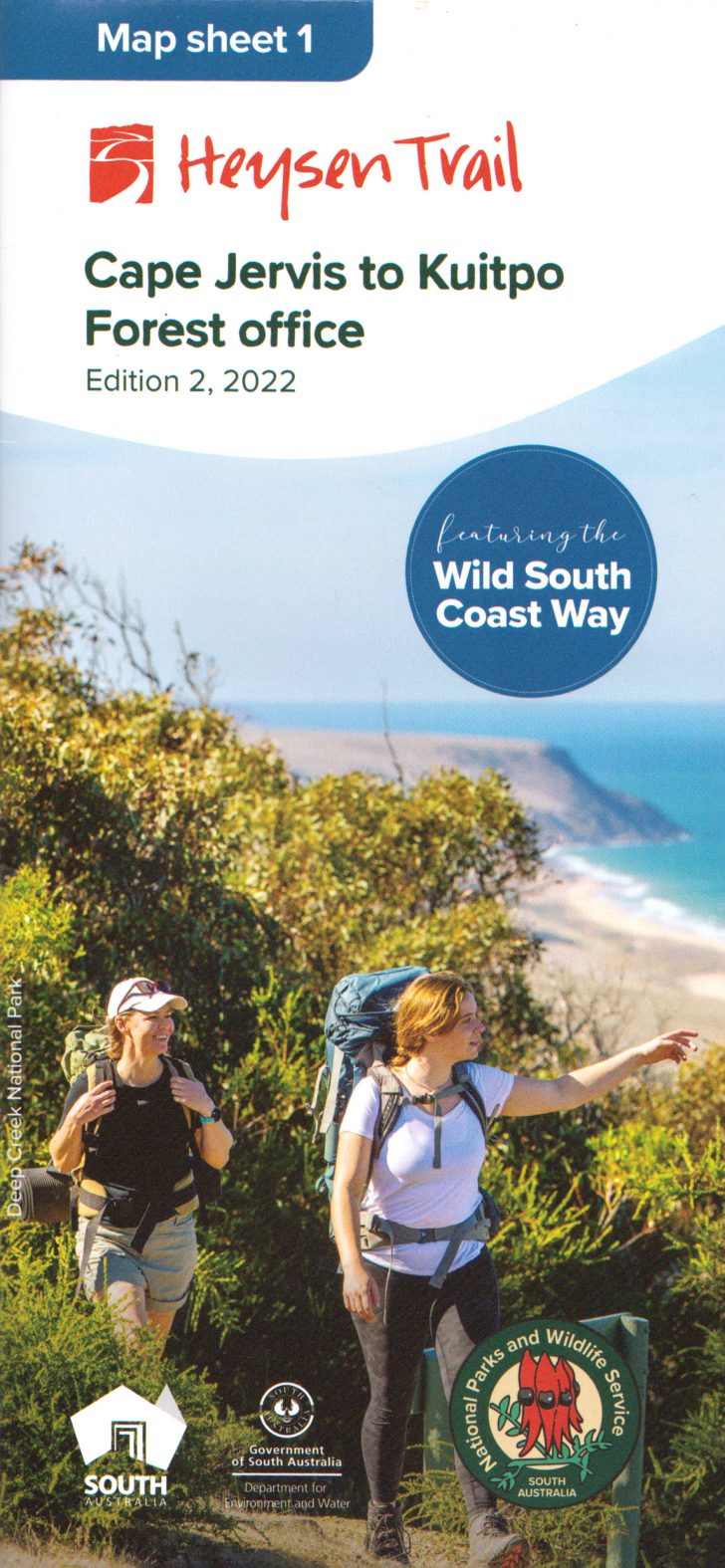
New Heysen Trail Map 1, including the Wild South Coast Way.

Release of the new Heysen Trail Map 1, incorporating the Wild South Coast Way

The Friends have taken delivery of the revised version of the Heysen Trail map sheet 1.  The newly released Edition 2 map covers the Cape Jervis to Kuitpo section of the trail. It incorporates the Wild South Coast Way on the Heysen Trail – the 74 km long series of spectacular walks between Cape Jervis & Victor Harbor.

You can purchase the new map sheet now via our online store, for $15 with postage from $3.70.

The map shows several spur and loop trails associated with the Wild South Coast Way, the new ‘walk-in’ campsites and other facilities erected on the trail. It also has information about when you can walk the Wild South Coast Way – it is open year round except on days of Cat­a­stroph­ic fire danger.

Remember, you can sign up to receive re-route notifications for your map sheet editions. All map sheets published since 2014 are available for notification.

The Friends map and book clearance sale continues

Meanwhile the Friends map and book clearance sale continues. We are running low on stock of most of our ‘to be discontinued lines’.

We’ve sold our last copy of Warren Bonython’s classic, ‘Walking the Flinders Ranges’. However, we have been advised that the Royal Geographical Society have a few remaining copies. If you missed out on reading the story that led to the creation of the Heysen Trail, you can purchase the book from the RGSSA .

Animal control program on the Fleurieu Peninsula, 19-30 September 2022

Map of the Wild South Coast Way, the Heysen Trail along the southern coastline of the Fleurieu Peninsula

Warning to walkers on the Wild South Coast Way on the Heysen Trail.

There will be an extensive aerial cull of feral deer on the Fleurieu Peninsula by PIRSA and other organisations, with the support of local landholders, between 19 and 30 of September 2022.

Walkers may be affected if in the region of  Boat Harbour Beach, Tunkalilla Beach and the trail to Ballaparudda Creek campground.

The cull will use helicopters carrying thermal technology to detect deer, allowing them to be culled even in dense scrub. Flights will be on week days and weekends, mainly around dawn and dusk, when thermal cameras can detect targets most easily.

The Wild South Coast Way will remain open to walkers during the operation

No shoot and low flying buffers will be put in place around the Wild South Coast Way (Heysen Trail) and Bullaparudda campground, as well as public roads and infrastructure.

There is no risk to people or livestock, but if you are in affected areas you may hear low flying helicopters and the sound of gun shots in the distance.

You can find out more information about the operation on the Parks Closure and Alerts page.